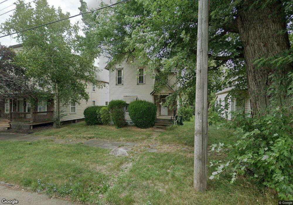
431 Hester Ave Alliance, OH 44601
Estimated Value: $81,664 - $107,000
3
Beds
1
Bath
1,460
Sq Ft
$62/Sq Ft
Est. Value
About This Home
This home is located at 431 Hester Ave, Alliance, OH 44601 and is currently estimated at $90,416, approximately $61 per square foot. 431 Hester Ave is a home located in Stark County with nearby schools including Alliance Early Learning School, Alliance Intermediate School at Northside, and Alliance Middle School.
Ownership History
Date
Name
Owned For
Owner Type
Purchase Details
Closed on
Oct 24, 2024
Sold by
Greater Alliance Development Corporation
Bought by
Watson Herbert E
Current Estimated Value
Purchase Details
Closed on
Apr 6, 2023
Sold by
Stark Cnty Land Reutilization
Bought by
Alliance City and Alliance Land Reutilizati
Purchase Details
Closed on
Feb 3, 2023
Sold by
Anderson William Glenn
Bought by
Stark County Land Reutilization Corporation
Purchase Details
Closed on
Jun 23, 2000
Sold by
Estate Of William R Yoder
Bought by
Anderson William Glenn
Create a Home Valuation Report for This Property
The Home Valuation Report is an in-depth analysis detailing your home's value as well as a comparison with similar homes in the area
Home Values in the Area
Average Home Value in this Area
Purchase History
We collect this data history from publicly available records. To have your information removed, we recommend requesting removal directly through your county’s website.
| Date | Buyer | Sale Price | Title Company |
|---|---|---|---|
| Watson Herbert E | -- | None Listed On Document | |
| Greater Alliance Development Corporation | -- | None Listed On Document | |
| Alliance City | -- | None Listed On Document | |
| Stark County Land Reutilization Corporation | -- | None Listed On Document | |
| Stark County Land Reutilization Corporation | $5,723,120 | None Listed On Document | |
| Anderson William Glenn | -- | -- |
Source: Public Records
Tax History
| Year | Tax Paid | Tax Assessment Tax Assessment Total Assessment is a certain percentage of the fair market value that is determined by local assessors to be the total taxable value of land and additions on the property. | Land | Improvement |
|---|---|---|---|---|
| 2025 | -- | $19,710 | $4,900 | $14,810 |
| 2024 | -- | $19,710 | $4,900 | $14,810 |
| 2023 | $10,685 | $9,700 | $2,490 | $7,210 |
| 2022 | $392 | $9,700 | $2,490 | $7,210 |
| 2021 | $393 | $9,700 | $2,490 | $7,210 |
| 2020 | $296 | $6,830 | $1,790 | $5,040 |
| 2019 | $292 | $6,830 | $1,790 | $5,040 |
| 2018 | $293 | $6,830 | $1,790 | $5,040 |
| 2017 | $6,817 | $5,960 | $1,510 | $4,450 |
| 2016 | $5,776 | $5,960 | $1,510 | $4,450 |
| 2015 | $278 | $5,960 | $1,510 | $4,450 |
| 2014 | $366 | $7,850 | $1,580 | $6,270 |
| 2013 | $183 | $7,850 | $1,580 | $6,270 |
Source: Public Records
Map
Nearby Homes
- 244 N Park Ave
- 105 W Ely St
- 260 W Washington St
- 171 1/2 W Main St
- 717 Garfield Ave
- 847 E Patterson St
- 1033 Walnut Ave
- 421 S Park Ave
- V/L S Freedom Ave
- 427 S Union Ave
- 223 E Oxford St
- 33 S Lincoln Ave
- 442 S Liberty Ave
- 11371 Walnut Ave NE
- 134 W Cambridge St
- 452 E Summit St
- 319 W Oxford St
- 456 W Broadway St
- 15832 Waverly St NE
- 11455 Walnut Ave NE
- 429 Hester Ave
- 447 Hester Ave
- 521 2nd St
- 419 Crawford Ct
- 421 Crawford Ct
- 409 Hester Ave
- 411 Hester Ave
- 505 Hester Ave
- 520 2nd St
- 516 N Freedom Ave
- 513 Hester Ave
- 512 N Freedom Ave
- 527 3rd St
- 517 Hester Ave
- 614 N Freedom Ave
- 0 Mechanic #47-49-51
- 620 N Freedom Ave
- 131 E Harrison St
- 626 N Freedom Ave
- 531 Hester Ave
Your Personal Tour Guide
Ask me questions while you tour the home.