Estimated Value: $295,000 - $324,000
3
Beds
2
Baths
1,708
Sq Ft
$181/Sq Ft
Est. Value
About This Home
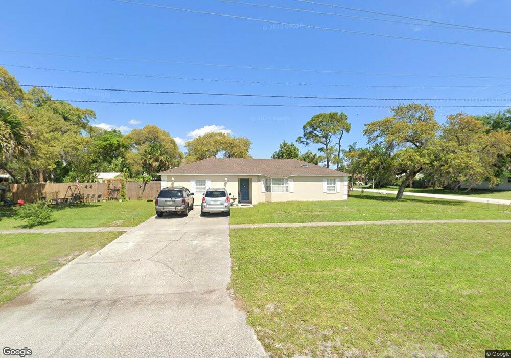
This home is located at 4460 Curtis Blvd, Cocoa, FL 32927 and is currently estimated at $308,969, approximately $180 per square foot. 4460 Curtis Blvd is a home located in Brevard County with nearby schools including Atlantis Elementary School, Space Coast Junior/Senior High School, and East Atlantic Prep of Brevard County.
Ownership History
Date
Name
Owned For
Owner Type
Purchase Details
Closed on
May 3, 2000
Sold by
Singleton Vernell L and Brown Jerolyn L
Bought by
Bryant Richard A and Bryant Tammy A
Current Estimated Value
Home Financials for this Owner
Home Financials are based on the most recent Mortgage that was taken out on this home.
Original Mortgage
$90,453
Outstanding Balance
$31,384
Interest Rate
8.2%
Estimated Equity
$277,585
Purchase Details
Closed on
Jul 28, 1994
Sold by
Singleton Vernell L and Brown Jerolyn L
Bought by
Singleton Vernell L and Brown Jerolyn L
Create a Home Valuation Report for This Property
The Home Valuation Report is an in-depth analysis detailing your home's value as well as a comparison with similar homes in the area
Home Values in the Area
Average Home Value in this Area
Purchase History
We collect this data history from publicly available records. To have your information removed, we recommend requesting removal directly through your county’s website.
| Date | Buyer | Sale Price | Title Company |
|---|---|---|---|
| Bryant Richard A | $90,500 | -- | |
| Singleton Vernell L | -- | -- |
Source: Public Records
Mortgage History
We collect this data history from publicly available records. To have your information removed, we recommend requesting removal directly through your county’s website.
| Date | Status | Borrower | Loan Amount |
|---|---|---|---|
| Open | Bryant Richard A | $90,453 |
Source: Public Records
Tax History
| Year | Tax Paid | Tax Assessment Tax Assessment Total Assessment is a certain percentage of the fair market value that is determined by local assessors to be the total taxable value of land and additions on the property. | Land | Improvement |
|---|---|---|---|---|
| 2025 | $1,239 | $88,550 | -- | -- |
| 2024 | $1,202 | $86,060 | -- | -- |
| 2023 | $1,202 | $83,560 | $0 | $0 |
| 2022 | $1,119 | $81,130 | $0 | $0 |
| 2021 | $1,107 | $78,770 | $0 | $0 |
| 2020 | $1,042 | $77,690 | $0 | $0 |
| 2019 | $975 | $75,950 | $0 | $0 |
| 2018 | $969 | $74,540 | $0 | $0 |
| 2017 | $969 | $73,010 | $0 | $0 |
| 2016 | $978 | $71,510 | $18,000 | $53,510 |
| 2015 | $988 | $71,020 | $15,000 | $56,020 |
| 2014 | $992 | $70,460 | $11,000 | $59,460 |
Source: Public Records
Map
Nearby Homes
- 7065 Bright Ave
- 4575 Curtis Blvd
- 7210 Barbara Rd
- 7250 Carlowe Ave
- 7081 Bayfront Rd
- 4625 Curtis Blvd
- 4515 Flood St
- 6990 Camden Ave
- 6905 Bentley Rd
- 7350 Bartow Ave
- 4765 Curtis Blvd
- 6800 Ackerman Ave
- 4821 Falcon Blvd
- 4770 Ivan St
- 4824 Curtis Blvd
- 7456 Camio Ave
- 00 Kings Hwy
- 7455 Darien Rd
- 4110 Delespine Rd
- 0000 Unknown St
- 7112 Bright Ave
- 7124 Bright Ave
- 7113 Carlowe Ave
- 7125 Carlowe Ave
- 4480 Curtis Blvd
- 4430 Curtis Blvd
- 7125 Bright Ave
- 7136 Bright Ave
- 7137 Carlowe Ave
- None Curtis Blvd
- 7149 Carlowe Ave
- 7031 Carlowe Ave
- 7137 Bright Ave
- 4420 Curtis Blvd
- 7148 Bright Ave
- 7205 Achilles Rd
- 4465 Curtis Blvd
- 7161 Carlowe Ave
- 4475 Curtis Blvd Unit 8
- 4475 Curtis Blvd
Your Personal Tour Guide
Ask me questions while you tour the home.