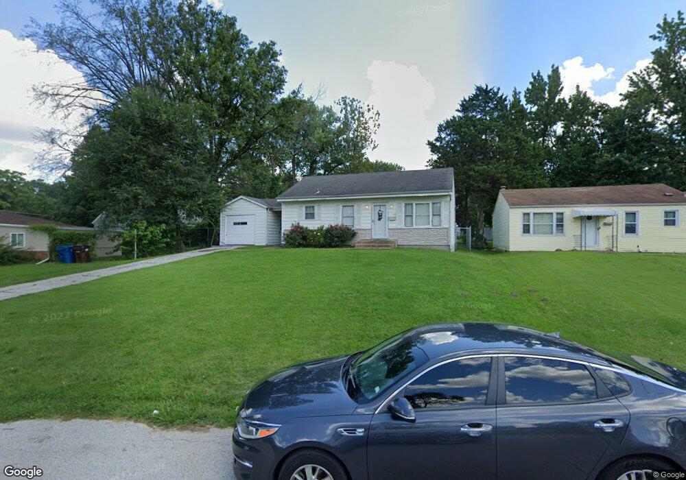
448 Thurston Ave Saint Louis, MO 63134
Estimated Value: $74,000 - $110,000
2
Beds
1
Bath
884
Sq Ft
$105/Sq Ft
Est. Value
About This Home
This home is located at 448 Thurston Ave, Saint Louis, MO 63134 and is currently estimated at $93,089, approximately $105 per square foot. 448 Thurston Ave is a home located in St. Louis County with nearby schools including Ferguson Middle School, Johnson Wabash Elementary School, and McCluer High School.
Ownership History
Date
Name
Owned For
Owner Type
Purchase Details
Closed on
Aug 15, 2025
Sold by
Fleming Roslyn Marie
Bought by
Jefferson Erick T
Current Estimated Value
Purchase Details
Closed on
Jul 23, 2022
Sold by
Buie Jacqueline D
Bought by
Fleming Roslyn Marie
Create a Home Valuation Report for This Property
The Home Valuation Report is an in-depth analysis detailing your home's value as well as a comparison with similar homes in the area
Home Values in the Area
Average Home Value in this Area
Purchase History
We collect this data history from publicly available records. To have your information removed, we recommend requesting removal directly through your county’s website.
| Date | Buyer | Sale Price | Title Company |
|---|---|---|---|
| Jefferson Erick T | -- | None Listed On Document | |
| Fleming Roslyn Marie | -- | None Listed On Document |
Source: Public Records
Tax History
| Year | Tax Paid | Tax Assessment Tax Assessment Total Assessment is a certain percentage of the fair market value that is determined by local assessors to be the total taxable value of land and additions on the property. | Land | Improvement |
|---|---|---|---|---|
| 2025 | $1,080 | $19,040 | $2,090 | $16,950 |
| 2024 | $1,080 | $14,760 | $1,670 | $13,090 |
| 2023 | $1,080 | $14,760 | $1,670 | $13,090 |
| 2022 | $873 | $10,390 | $1,250 | $9,140 |
| 2021 | $845 | $10,390 | $1,250 | $9,140 |
| 2020 | $892 | $9,880 | $1,710 | $8,170 |
| 2019 | $875 | $9,880 | $1,710 | $8,170 |
| 2018 | $852 | $8,570 | $1,410 | $7,160 |
| 2017 | $836 | $8,570 | $1,410 | $7,160 |
| 2016 | $1,018 | $10,340 | $1,790 | $8,550 |
| 2015 | $1,025 | $10,340 | $1,790 | $8,550 |
| 2014 | $1,034 | $10,320 | $2,300 | $8,020 |
Source: Public Records
Map
Nearby Homes
- 321 Henquin Dr
- 324 Henquin Dr
- 6314 Peurifoy Ave
- 238 Newell Dr
- 6232 Witsell Ave
- 6234 Peurifoy Ave
- 1001 Olympia Dr
- 8140 Packard Ave
- 6621 Dunwold Dr
- 6135 Shillington Dr
- 218 N Marguerite Ave
- 415 Warford Ave
- 106 Henquin Dr
- 411 Warford Ave
- 8115 Myrick St
- 129 N Dade Ave
- 605 Abston Ave
- 8146 Rector Dr
- 138 N Marguerite Ave
- 2 Marcel Ct
- 444 Thurston Ave
- 1010 January Ave
- 454 Thurston Ave
- 1006 January Ave
- 436 Thurston Ave
- 928 January Ave
- 430 Thurston Ave
- 439 Thurston Ave
- 435 Thurston Ave
- 431 Thurston Ave
- 920 January Ave
- 420 Thurston Ave
- 8 Plymouth Ct
- 1011 January Ave
- 1007 January Ave
- 7 Plymouth Ct
- 8000 January Ave
- 1019 January Ave
- 1 Caldwell Ct
- 501 Ford Dr
Your Personal Tour Guide
Ask me questions while you tour the home.