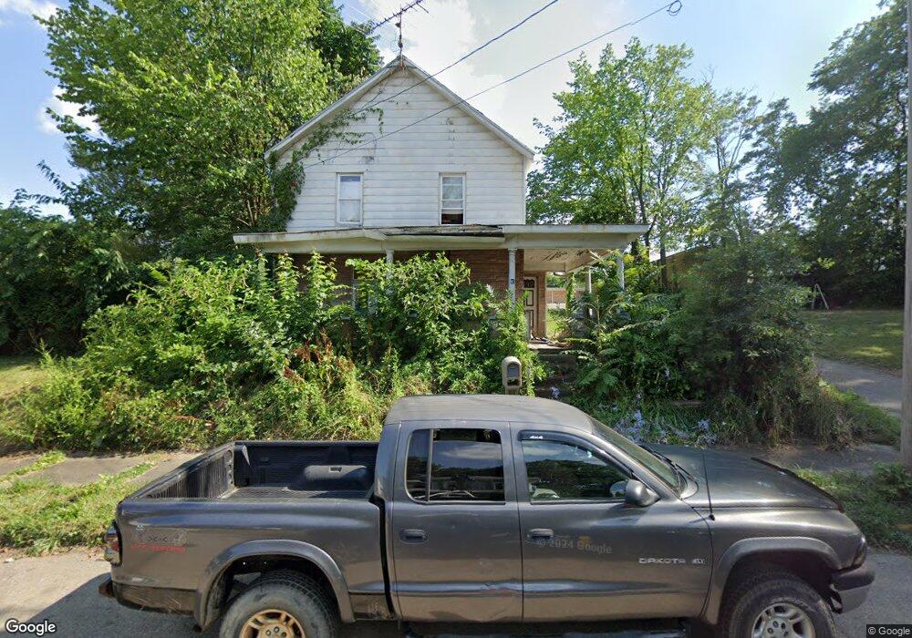
45 E Columbia St Alliance, OH 44601
Estimated Value: $69,000 - $103,000
3
Beds
1
Bath
1,360
Sq Ft
$60/Sq Ft
Est. Value
About This Home
This home is located at 45 E Columbia St, Alliance, OH 44601 and is currently estimated at $81,958, approximately $60 per square foot. 45 E Columbia St is a home located in Stark County with nearby schools including Alliance Intermediate School at Northside, Alliance Elementary School at Rockhill, and Alliance Middle School.
Ownership History
Date
Name
Owned For
Owner Type
Purchase Details
Closed on
Mar 5, 2024
Sold by
Alliance Area Habitat/Humanity
Bought by
Alliance Area Habitat/Humanity
Current Estimated Value
Purchase Details
Closed on
May 15, 2023
Sold by
Glc Enterprises Llc and Csanad George
Bought by
Casanad Adam
Purchase Details
Closed on
Mar 12, 2021
Sold by
Matyi Dwayne and Matyi Dwayna
Bought by
Glc Enterprises Llc
Purchase Details
Closed on
Mar 14, 2017
Sold by
Pederzolli Property Holdings I Llc and Pederzolli Angelo
Bought by
Matyt Dwayne
Purchase Details
Closed on
Jun 9, 2011
Sold by
Pederzolli Joseph M and Dietrich Karen A
Bought by
Pederzolli Property Holdings Llc
Purchase Details
Closed on
Dec 9, 1994
Sold by
Mcfarland Kenneth E
Bought by
Pederzolli Andrew C
Create a Home Valuation Report for This Property
The Home Valuation Report is an in-depth analysis detailing your home's value as well as a comparison with similar homes in the area
Home Values in the Area
Average Home Value in this Area
Purchase History
| Date | Buyer | Sale Price | Title Company |
|---|---|---|---|
| Alliance Area Habitat/Humanity | -- | None Listed On Document | |
| Casanad Adam | $206,320 | None Listed On Document | |
| Glc Enterprises Llc | $3,000 | None Available | |
| Matyt Dwayne | $2,000 | None Available | |
| Pederzolli Property Holdings Llc | -- | Attorney | |
| Pederzolli Andrew C | $10,000 | -- |
Source: Public Records
Tax History
| Year | Tax Paid | Tax Assessment Tax Assessment Total Assessment is a certain percentage of the fair market value that is determined by local assessors to be the total taxable value of land and additions on the property. | Land | Improvement |
|---|---|---|---|---|
| 2025 | $824 | $7,630 | $3,920 | $3,710 |
| 2024 | $243 | $7,630 | $3,920 | $3,710 |
| 2023 | $350 | $4,980 | $2,140 | $2,840 |
| 2022 | $206 | $4,980 | $2,140 | $2,840 |
| 2021 | $207 | $4,980 | $2,140 | $2,840 |
| 2020 | $240 | $5,400 | $1,860 | $3,540 |
| 2019 | $237 | $5,400 | $1,860 | $3,540 |
| 2018 | $238 | $5,400 | $1,860 | $3,540 |
| 2017 | $220 | $4,910 | $1,540 | $3,370 |
| 2016 | $347 | $7,670 | $1,540 | $6,130 |
| 2015 | $350 | $7,670 | $1,540 | $6,130 |
| 2014 | $270 | $5,640 | $1,400 | $4,240 |
| 2013 | $135 | $5,640 | $1,400 | $4,240 |
Source: Public Records
Map
Nearby Homes
- 62 E Market St
- 427 S Union Ave
- 163 W Market St
- 171 1/2 W Main St
- 361 E Main St
- 228 W Oxford St
- V/L S Freedom Ave
- 233 W Cambridge St
- 621 S Haines Ave
- 33 S Lincoln Ave
- 726 S Arch Ave
- 343 W Columbia St
- 319 W Oxford St
- 118 S Mckinley Ave
- 807 S Union Ave
- 452 E Summit St
- 505 N Union Ave
- 710 N Freedom Ave
- 535 S Mckinley Ave
- 46 Rosenberry St
- 33 E Columbia St
- 61 E Columbia St
- 67 E Columbia St
- 219 S Park Ave
- 46 E Broadway St
- 204 S Union Ave
- 62 E Broadway St
- 227 S Park Ave
- 44 E Columbia St
- 54 E Columbia St
- 226 S Union Ave
- 62 E Columbia St
- 42 E Columbia St
- 72 E Broadway St
- 222 S Park Ave
- 101 E Columbia St
- 37 E Broadway St
- 111 E Columbia St
- 111 E Columbia St
- 146 S Park Ave
Your Personal Tour Guide
Ask me questions while you tour the home.