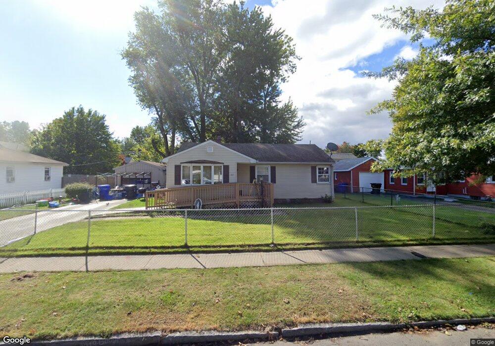
45 Rowland St Springfield, MA 01107
Brightwood NeighborhoodEstimated Value: $265,000 - $286,000
3
Beds
2
Baths
962
Sq Ft
$287/Sq Ft
Est. Value
About This Home
This home is located at 45 Rowland St, Springfield, MA 01107 and is currently estimated at $276,179, approximately $287 per square foot. 45 Rowland St is a home located in Hampden County with nearby schools including High School Of Commerce, Springfield High School of Science and Technology, and Roger L. Putnam Vocational Technical Academy.
Ownership History
Date
Name
Owned For
Owner Type
Purchase Details
Closed on
Mar 24, 2008
Sold by
Burney Ronald W
Bought by
Burney Carmen and Burney Ronald W
Current Estimated Value
Purchase Details
Closed on
Mar 12, 2007
Sold by
Burney Grace
Bought by
Burney Grace and Burney Ronald W
Create a Home Valuation Report for This Property
The Home Valuation Report is an in-depth analysis detailing your home's value as well as a comparison with similar homes in the area
Home Values in the Area
Average Home Value in this Area
Purchase History
| Date | Buyer | Sale Price | Title Company |
|---|---|---|---|
| Burney Carmen | -- | -- | |
| Burney Grace | -- | -- |
Source: Public Records
Tax History
| Year | Tax Paid | Tax Assessment Tax Assessment Total Assessment is a certain percentage of the fair market value that is determined by local assessors to be the total taxable value of land and additions on the property. | Land | Improvement |
|---|---|---|---|---|
| 2025 | $3,506 | $223,600 | $31,900 | $191,700 |
| 2024 | $3,448 | $214,700 | $31,900 | $182,800 |
| 2023 | $3,367 | $197,500 | $29,000 | $168,500 |
| 2022 | $2,729 | $145,000 | $27,100 | $117,900 |
| 2021 | $2,474 | $130,900 | $24,600 | $106,300 |
| 2020 | $2,312 | $118,400 | $24,600 | $93,800 |
| 2019 | $2,098 | $106,600 | $24,600 | $82,000 |
| 2018 | $2,055 | $104,400 | $24,600 | $79,800 |
| 2017 | $1,919 | $97,600 | $18,500 | $79,100 |
| 2016 | $1,703 | $86,600 | $18,500 | $68,100 |
| 2015 | $1,668 | $84,800 | $18,500 | $66,300 |
Source: Public Records
Map
Nearby Homes
- 50-54 Orchard St
- 28 Larone Ave
- 224 Riverdale St
- 62 Washburn St
- 21 Merwin St
- 917 Elm St
- 31 Washburn St
- 20-22 Gay Terrace
- 48-50 Elm Cir
- 49-53 Jefferson Ave
- 334 Elm St
- 2 Windpath E
- 52 Osgood St
- 58 Field St
- 26 Hebron St
- 85 Narragansett St
- 57 Narragansett St
- 113 Lexington St
- 35-37 Narragansett St
- 78 Prospect St
- 37 Rowland St
- 51 Rowland St
- 92 Clayton St
- 59 Rowland St
- 100 Clayton St
- 27 Rowland St
- 50 Rowland St
- 76 Clayton St
- 38 Rowland St Unit 40
- 58 Rowland St
- 108 Clayton St
- 70 Clayton St Unit 72
- 67 Rowland St
- 64 Rowland St
- 66 Clayton St Unit 68
- 24 Rowland St
- 43 Abbe Ave
- 35 Abbe Ave
- 120 Clayton St
- 85 Clayton St
Your Personal Tour Guide
Ask me questions while you tour the home.