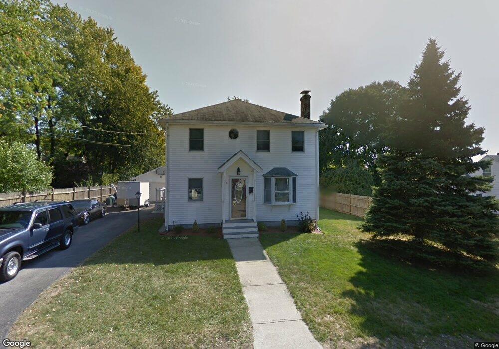
46 Dobson Rd Braintree, MA 02184
East Braintree NeighborhoodEstimated Value: $684,000 - $848,000
4
Beds
3
Baths
2,694
Sq Ft
$283/Sq Ft
Est. Value
About This Home
This home is located at 46 Dobson Rd, Braintree, MA 02184 and is currently estimated at $761,158, approximately $282 per square foot. 46 Dobson Rd is a home located in Norfolk County with nearby schools including Braintree High School, Noble Academy, and Step Ahead Kindergarten.
Ownership History
Date
Name
Owned For
Owner Type
Purchase Details
Closed on
Nov 29, 1996
Sold by
Devincentis Nicholas
Bought by
Willis George J and Willis Lisa
Current Estimated Value
Create a Home Valuation Report for This Property
The Home Valuation Report is an in-depth analysis detailing your home's value as well as a comparison with similar homes in the area
Home Values in the Area
Average Home Value in this Area
Purchase History
| Date | Buyer | Sale Price | Title Company |
|---|---|---|---|
| Willis George J | $157,000 | -- | |
| Willis George J | $157,000 | -- |
Source: Public Records
Mortgage History
| Date | Status | Borrower | Loan Amount |
|---|---|---|---|
| Open | Willis George J | $298,000 | |
| Closed | Willis George J | $275,000 | |
| Closed | Willis George J | $224,000 |
Source: Public Records
Tax History
| Year | Tax Paid | Tax Assessment Tax Assessment Total Assessment is a certain percentage of the fair market value that is determined by local assessors to be the total taxable value of land and additions on the property. | Land | Improvement |
|---|---|---|---|---|
| 2025 | $7,365 | $738,000 | $361,600 | $376,400 |
| 2024 | $6,627 | $699,000 | $339,000 | $360,000 |
| 2023 | $6,236 | $638,900 | $298,300 | $340,600 |
| 2022 | $6,087 | $611,800 | $271,200 | $340,600 |
| 2021 | $5,471 | $549,800 | $228,700 | $321,100 |
| 2020 | $5,421 | $549,800 | $228,700 | $321,100 |
| 2019 | $5,207 | $516,100 | $228,700 | $287,400 |
| 2018 | $5,002 | $474,600 | $198,900 | $275,700 |
| 2017 | $4,777 | $444,800 | $180,800 | $264,000 |
| 2016 | $4,514 | $411,100 | $162,700 | $248,400 |
| 2015 | $4,404 | $397,800 | $159,100 | $238,700 |
| 2014 | $4,198 | $367,600 | $146,400 | $221,200 |
Source: Public Records
Map
Nearby Homes
- 18 Hobart St
- 30 Skyline Dr Unit 6
- 37 Skyline Dr Unit 11
- 300 Commercial St Unit 23
- 82 Cotton Ave
- 25 W Howard St Unit C3
- 54 Edgemont Rd
- 599 Union St
- 15 Bower Rd Unit F9
- 140 Commercial St
- 14 Hillside Rd
- 41 Lantern Ln
- 37 Lantern Ln
- 67 Trefton Dr
- 200 Falls Blvd Unit E101
- 200 Falls Blvd Unit B305
- 21 Spaulding St
- 17 White Rd
- 86 E Howard St Unit 107
- 87 Arborway Dr
Your Personal Tour Guide
Ask me questions while you tour the home.