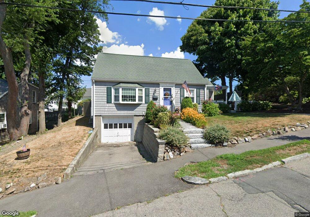
46 Trevore St Quincy, MA 02171
Squantum NeighborhoodEstimated Value: $718,317 - $747,000
3
Beds
2
Baths
1,279
Sq Ft
$573/Sq Ft
Est. Value
About This Home
This home is located at 46 Trevore St, Quincy, MA 02171 and is currently estimated at $732,829, approximately $572 per square foot. 46 Trevore St is a home located in Norfolk County with nearby schools including Squantum Elementary School, Atlantic Middle School, and North Quincy High School.
Ownership History
Date
Name
Owned For
Owner Type
Purchase Details
Closed on
Jan 3, 2024
Sold by
Byrne Kathleen
Bought by
Kathleen Byrne Irt and Gribaudo
Current Estimated Value
Purchase Details
Closed on
Feb 19, 1999
Sold by
Byrne Charles L and Byrne Margaret T
Bought by
Byrne Kathleen
Purchase Details
Closed on
Oct 29, 1993
Sold by
Fnma
Bought by
Byrne Charles L and Byrne Margaret T
Purchase Details
Closed on
Jul 22, 1993
Sold by
Doyle John J
Bought by
Gmac Mtg Corp Of Iowa
Create a Home Valuation Report for This Property
The Home Valuation Report is an in-depth analysis detailing your home's value as well as a comparison with similar homes in the area
Home Values in the Area
Average Home Value in this Area
Purchase History
We collect this data history from publicly available records. To have your information removed, we recommend requesting removal directly through your county’s website.
| Date | Buyer | Sale Price | Title Company |
|---|---|---|---|
| Kathleen Byrne Irt | -- | None Available | |
| Kathleen Byrne Irt | -- | None Available | |
| Byrne Kathleen | $130,000 | -- | |
| Byrne Charles L | $145,000 | -- | |
| Gmac Mtg Corp Of Iowa | $149,613 | -- | |
| Gmac Mtg Corp Of Iowa | $149,613 | -- |
Source: Public Records
Mortgage History
We collect this data history from publicly available records. To have your information removed, we recommend requesting removal directly through your county’s website.
| Date | Status | Borrower | Loan Amount |
|---|---|---|---|
| Previous Owner | Gmac Mtg Corp Of Iowa | $80,000 | |
| Previous Owner | Gmac Mtg Corp Of Iowa | $215,500 |
Source: Public Records
Tax History
| Year | Tax Paid | Tax Assessment Tax Assessment Total Assessment is a certain percentage of the fair market value that is determined by local assessors to be the total taxable value of land and additions on the property. | Land | Improvement |
|---|---|---|---|---|
| 2025 | $7,699 | $667,700 | $397,000 | $270,700 |
| 2024 | $7,285 | $646,400 | $378,100 | $268,300 |
| 2023 | $6,574 | $590,700 | $360,100 | $230,600 |
| 2022 | $6,215 | $518,800 | $300,100 | $218,700 |
| 2021 | $6,195 | $510,300 | $300,100 | $210,200 |
| 2020 | $5,877 | $472,800 | $272,800 | $200,000 |
| 2019 | $5,632 | $448,800 | $272,800 | $176,000 |
| 2018 | $5,715 | $428,400 | $259,800 | $168,600 |
| 2017 | $5,217 | $368,200 | $225,900 | $142,300 |
| 2016 | $4,858 | $338,300 | $205,400 | $132,900 |
| 2015 | $4,850 | $332,200 | $205,400 | $126,800 |
| 2014 | $4,693 | $315,800 | $205,400 | $110,400 |
Source: Public Records
Map
Nearby Homes
- 151 Dorchester St
- 130 Parke Ave (Lot 2)
- 7 Dorchester St Unit 3
- 1 Parke Ave
- 865 E Squantum St
- 62 Bay St
- 63 Crabtree Rd
- 63 Crabtree Rd (Lot B)
- 63 Crabtree Rd (Lot A)
- 10 Sloop Ln Unit 87
- 7 Cutter Ln
- 7 Whaler Ln
- 156 Crabtree Rd
- 1001 Marina Dr Unit 705
- 1001 Marina Dr Unit 708
- 1001 Marina Dr Unit 301
- 2001 Marina Dr Unit 506W
- 2001 Marina Dr Unit 211
- 2001 Marina Dr Unit 605
- 52 Tilden Commons Dr Unit 52
- 34 Trevore St
- 34 Trevore St Unit 2
- 40 Trevore St
- 26 Trevore St
- 15 Bellevue Rd
- 21 Bellevue Rd
- 2 Mayflower Rd
- 9 Bellevue Rd
- 1 Mayflower Rd
- 27 Bellevue Rd
- 6 Mayflower Rd
- 22 Trevore St
- 105 Dorchester St Unit 1
- 43 Trevore St
- 5 Mayflower Rd
- 16 Trevore St
- 10 Mayflower Rd
- 107 Dorchester St
- 111 Dorchester St Unit 111
- 111 Dorchester St
Your Personal Tour Guide
Ask me questions while you tour the home.