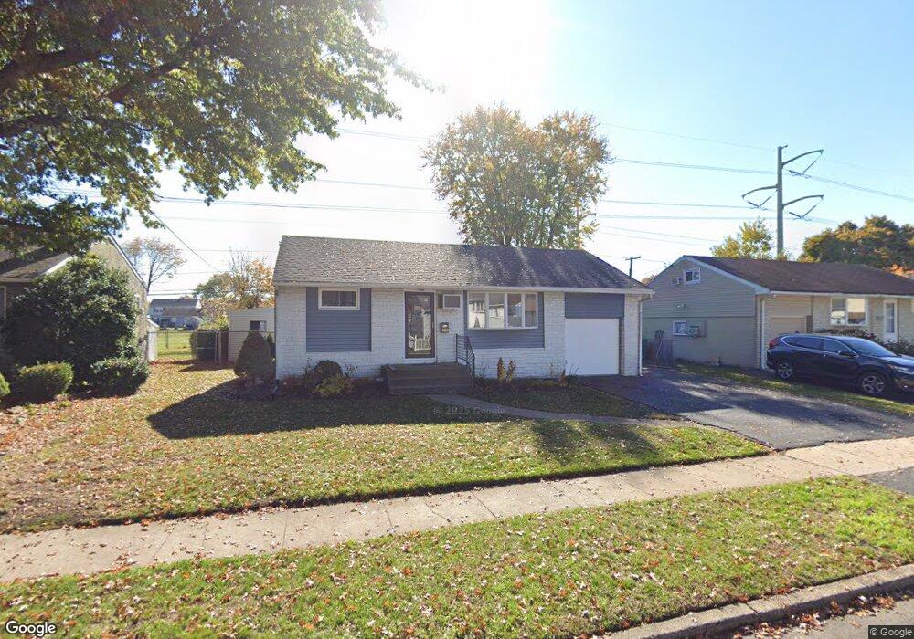
4612 Brookside Ave Bristol, PA 19007
Estimated Value: $230,000 - $350,000
About This Home
This home is located at 4612 Brookside Ave, Bristol, PA 19007 and is currently estimated at $300,478, approximately $362 per square foot. 4612 Brookside Ave is a home located in Bucks County with nearby schools including Truman Senior High School, First Presbyterian Church School, and Isabet Academy.
Ownership History
We collect this data history from publicly available records. To have your information removed, we recommend requesting removal directly through your county’s website.
Purchase Details
Home Financials for this Owner
Home Financials are based on the most recent Mortgage that was taken out on this home.Purchase Details
Home Values in the Area
Average Home Value in this Area
Purchase History
We collect this data history from publicly available records. To have your information removed, we recommend requesting removal directly through your county’s website.
| Date | Buyer | Sale Price | Title Company |
|---|---|---|---|
| $125,000 | First American Title Ins Co | ||
| $10,600 | -- |
Mortgage History
We collect this data history from publicly available records. To have your information removed, we recommend requesting removal directly through your county’s website.
| Date | Status | Borrower | Loan Amount |
|---|---|---|---|
| Open | $121,250 |
Tax History
We collect this data history from publicly available records. To have your information removed, we recommend requesting removal directly through your county’s website.
| Year | Tax Paid | Tax Assessment Tax Assessment Total Assessment is a certain percentage of the fair market value that is determined by local assessors to be the total taxable value of land and additions on the property. | Land | Improvement |
|---|---|---|---|---|
| 2026 | $3,925 | $14,400 | $4,320 | $10,080 |
| 2025 | $3,911 | $14,400 | $4,320 | $10,080 |
| 2024 | $3,911 | $14,400 | $4,320 | $10,080 |
| 2023 | $3,882 | $14,400 | $4,320 | $10,080 |
| 2022 | $3,882 | $14,400 | $4,320 | $10,080 |
| 2021 | $3,882 | $14,400 | $4,320 | $10,080 |
| 2020 | $3,882 | $14,400 | $4,320 | $10,080 |
| 2019 | $3,867 | $14,400 | $4,320 | $10,080 |
| 2018 | $3,805 | $14,400 | $4,320 | $10,080 |
| 2017 | $3,747 | $14,400 | $4,320 | $10,080 |
| 2016 | $3,747 | $14,400 | $4,320 | $10,080 |
| 2015 | $2,632 | $14,400 | $4,320 | $10,080 |
| 2014 | $2,632 | $14,400 | $4,320 | $10,080 |
Map
- 4627 Gary Dr
- 52 Natalie Ct Unit 303
- 216 Jennifer Ct Unit 1210
- 7 Misty Pine Rd
- 68 Butternut Rd
- 55 Balsam Rd
- 162 Commerce Cir
- 160 Commerce Cir
- 158 Commerce Cir
- 156 Commerce Cir
- 154 Commerce Cir
- 27 Bittersweet Rd
- 152 Commerce Cir
- 150 Delhaas Cir
- 148 Delhaas Cir
- 146 Delhaas Cir
- 31 Micahill Rd
- 142 Delhaas Cir
- 144 Delhaas Cir
- 140 Delhaas Cir
- 4611 Brookside Ave
- 4613 Brookside Ave
- 4609 Brookside Ave
- 4615 Brookside Ave
- 2505 Winton Dr
- 4614 Brookside Ave
- 2500 Green Ave
- 4616 Brookside Ave
- 4610 Brookside Ave
- 2502 Green Ave
- 2507 Winton Dr
- 4618 Brookside Ave
- 2503 Winton Dr
- 4608 Brookside Ave
- 2501 Winton Dr
- 2504 Green Ave
- 4606 Brookside Ave
- 4620 Brookside Ave
- 2506 Green Ave
- 2500 Winton Dr
Ask me questions while you tour the home.