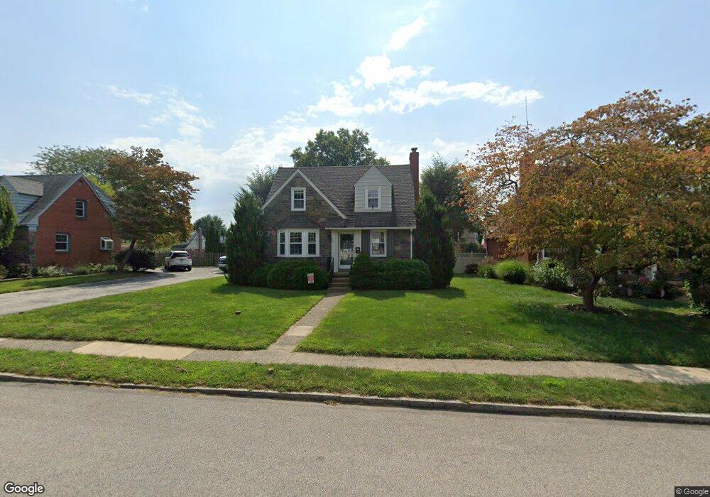
463 Thatcher Rd Springfield, PA 19064
Estimated Value: $429,000 - $454,000
3
Beds
2
Baths
1,438
Sq Ft
$309/Sq Ft
Est. Value
About This Home
This home is located at 463 Thatcher Rd, Springfield, PA 19064 and is currently estimated at $444,493, approximately $309 per square foot. 463 Thatcher Rd is a home located in Delaware County with nearby schools including Springfield High School and St Francis Of Assisi School.
Ownership History
Date
Name
Owned For
Owner Type
Purchase Details
Closed on
Nov 24, 2020
Sold by
Thompson Bernard F and Estate Of H Irvin Morris
Bought by
Nilan Joseph S
Current Estimated Value
Home Financials for this Owner
Home Financials are based on the most recent Mortgage that was taken out on this home.
Original Mortgage
$291,000
Interest Rate
2.6%
Mortgage Type
New Conventional
Purchase Details
Closed on
Jul 13, 1954
Bought by
Morris Morris H and Morris Evelyn
Create a Home Valuation Report for This Property
The Home Valuation Report is an in-depth analysis detailing your home's value as well as a comparison with similar homes in the area
Home Values in the Area
Average Home Value in this Area
Purchase History
| Date | Buyer | Sale Price | Title Company |
|---|---|---|---|
| Nilan Joseph S | $300,000 | City Abstract | |
| Morris Morris H | -- | -- |
Source: Public Records
Mortgage History
| Date | Status | Borrower | Loan Amount |
|---|---|---|---|
| Previous Owner | Nilan Joseph S | $291,000 |
Source: Public Records
Tax History
| Year | Tax Paid | Tax Assessment Tax Assessment Total Assessment is a certain percentage of the fair market value that is determined by local assessors to be the total taxable value of land and additions on the property. | Land | Improvement |
|---|---|---|---|---|
| 2025 | $7,542 | $268,330 | $95,740 | $172,590 |
| 2024 | $7,542 | $268,330 | $95,740 | $172,590 |
| 2023 | $7,262 | $268,330 | $95,740 | $172,590 |
| 2022 | $7,105 | $268,330 | $95,740 | $172,590 |
| 2021 | $11,003 | $268,330 | $95,740 | $172,590 |
| 2020 | $6,781 | $149,650 | $46,030 | $103,620 |
| 2019 | $6,622 | $149,650 | $46,030 | $103,620 |
| 2018 | $6,527 | $149,650 | $0 | $0 |
| 2017 | $6,376 | $149,650 | $0 | $0 |
| 2016 | $821 | $149,650 | $0 | $0 |
| 2015 | $838 | $149,650 | $0 | $0 |
| 2014 | $821 | $149,650 | $0 | $0 |
Source: Public Records
Map
Nearby Homes
- 493 Wheatsheaf Rd
- 231 E Woodland Ave
- 364 S Rolling Rd
- 264 Pancoast Ave
- 720 Evans Rd
- 658 E Leamy Ave
- 249 Gleaves Rd
- 933 Greenbriar Ln
- 253 Saxer Ave
- 1363 Palmer Dr Unit O122
- 334 Parham Rd
- 1291 Country Club Dr Unit Q137
- 114 Providence Rd
- 341 Harwicke Rd
- 359 Spring Valley Rd
- 225 Lynbrooke Rd
- 238 Alliston Rd
- 525 N Swarthmore Ave
- 436 Kerr Ln
- 507 School St
- 457 Thatcher Rd
- 469 Thatcher Rd
- 460 Barker Rd
- 473 Thatcher Rd
- 454 Barker Rd
- 453 Thatcher Rd
- 466 Barker Rd
- 450 Barker Rd
- 462 Thatcher Rd
- 466 Thatcher Rd
- 477 Thatcher Rd
- 400 Barker Rd
- 472 Barker Rd
- 449 Thatcher Rd
- 456 Thatcher Rd
- 472 Thatcher Rd
- 444 Barker Rd
- 452 Thatcher Rd
- 478 Barker Rd
- 483 Thatcher Rd
Your Personal Tour Guide
Ask me questions while you tour the home.