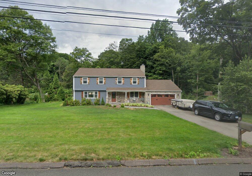
464 Brownstone Ridge Meriden, CT 06451
Estimated Value: $466,000 - $554,000
5
Beds
3
Baths
2,332
Sq Ft
$216/Sq Ft
Est. Value
About This Home
This home is located at 464 Brownstone Ridge, Meriden, CT 06451 and is currently estimated at $504,206, approximately $216 per square foot. 464 Brownstone Ridge is a home located in New Haven County with nearby schools including Hanover School, Lincoln Middle School, and Orville H. Platt High School.
Ownership History
Date
Name
Owned For
Owner Type
Purchase Details
Closed on
May 31, 2018
Sold by
Carter Steven J
Bought by
Carter Ret 2018
Current Estimated Value
Purchase Details
Closed on
Nov 24, 2009
Sold by
Carter Cheryl L
Bought by
Carter Steven J
Purchase Details
Closed on
Jun 13, 1997
Sold by
Burbank Donald and Burbank Anni L
Bought by
Carter Steven J and Carter Cheryl L
Home Financials for this Owner
Home Financials are based on the most recent Mortgage that was taken out on this home.
Original Mortgage
$148,000
Interest Rate
7.97%
Mortgage Type
Unknown
Create a Home Valuation Report for This Property
The Home Valuation Report is an in-depth analysis detailing your home's value as well as a comparison with similar homes in the area
Home Values in the Area
Average Home Value in this Area
Purchase History
| Date | Buyer | Sale Price | Title Company |
|---|---|---|---|
| Carter Ret 2018 | -- | -- | |
| Carter Steven J | -- | -- | |
| Carter Steven J | $185,000 | -- |
Source: Public Records
Mortgage History
| Date | Status | Borrower | Loan Amount |
|---|---|---|---|
| Previous Owner | Carter Steven J | $150,000 | |
| Previous Owner | Carter Steven J | $148,000 | |
| Previous Owner | Carter Steven J | $148,000 |
Source: Public Records
Tax History
| Year | Tax Paid | Tax Assessment Tax Assessment Total Assessment is a certain percentage of the fair market value that is determined by local assessors to be the total taxable value of land and additions on the property. | Land | Improvement |
|---|---|---|---|---|
| 2025 | $9,827 | $245,070 | $59,010 | $186,060 |
| 2024 | $8,898 | $245,070 | $59,010 | $186,060 |
| 2023 | $8,526 | $245,070 | $59,010 | $186,060 |
| 2022 | $8,085 | $245,070 | $59,010 | $186,060 |
| 2021 | $8,420 | $206,080 | $66,710 | $139,370 |
| 2020 | $8,420 | $206,080 | $66,710 | $139,370 |
| 2019 | $8,420 | $206,080 | $66,710 | $139,370 |
| 2018 | $8,458 | $206,080 | $66,710 | $139,370 |
| 2017 | $8,227 | $206,080 | $66,710 | $139,370 |
| 2016 | $7,931 | $216,510 | $59,640 | $156,870 |
| 2015 | $7,931 | $216,510 | $59,640 | $156,870 |
| 2014 | $7,738 | $216,510 | $59,640 | $156,870 |
Source: Public Records
Map
Nearby Homes
- 448 Brownstone Ridge
- 478 Brownstone Ridge
- 300 Brownstone Ridge
- 496 Brownstone Ridge
- 428 Brownstone Ridge
- 280 Brownstone Ridge
- 461 Brownstone Ridge
- 477 Brownstone Ridge
- 449 Brownstone Ridge
- 491 Brownstone Ridge
- 340 Brownstone Ridge
- 510 Brownstone Ridge
- 406 Brownstone Ridge
- 256 Brownstone Ridge
- 507 Brownstone Ridge
- 435 Brownstone Ridge
- 350 Brownstone Ridge
- 309 Brownstone Ridge
- 333 Brownstone Ridge
- 524 Brownstone Ridge
Your Personal Tour Guide
Ask me questions while you tour the home.