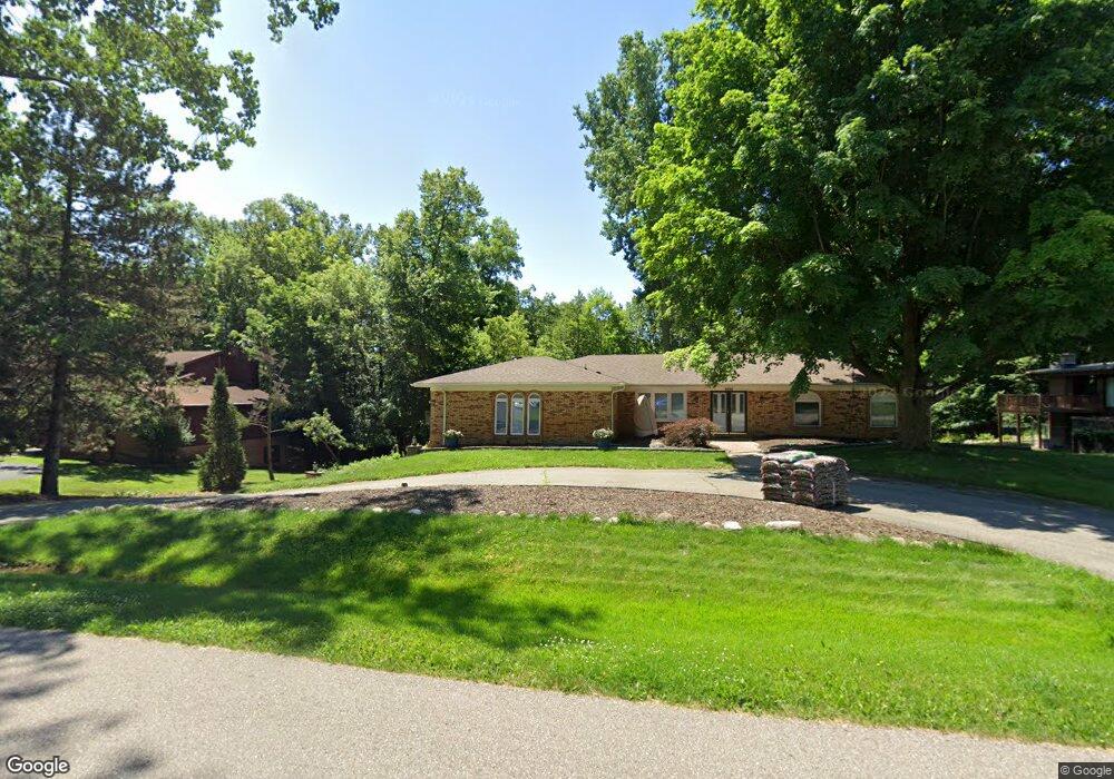
4645 Patrick Rd West Bloomfield, MI 48322
West Bloomfield Township NeighborhoodEstimated Value: $405,000 - $542,000
About This Home
This home is located at 4645 Patrick Rd, West Bloomfield, MI 48322 and is currently estimated at $481,550, approximately $200 per square foot. 4645 Patrick Rd is a home located in Oakland County with nearby schools including Sheiko Elementary School, Brookfield Academy - West Bloomfield, and The Susan And Rabbi Harold Loss Ecc.
Ownership History
We collect this data history from publicly available records. To have your information removed, we recommend requesting removal directly through your county’s website.
Purchase Details
Purchase Details
Purchase Details
Home Financials for this Owner
Home Financials are based on the most recent Mortgage that was taken out on this home.Purchase Details
Home Values in the Area
Average Home Value in this Area
Purchase History
We collect this data history from publicly available records. To have your information removed, we recommend requesting removal directly through your county’s website.
| Date | Buyer | Sale Price | Title Company |
|---|---|---|---|
| $273,850 | None Available | ||
| -- | None Available | ||
| $225,000 | -- | ||
| -- | -- |
Mortgage History
We collect this data history from publicly available records. To have your information removed, we recommend requesting removal directly through your county’s website.
| Date | Status | Borrower | Loan Amount |
|---|---|---|---|
| Previous Owner | $180,000 |
Tax History
We collect this data history from publicly available records. To have your information removed, we recommend requesting removal directly through your county’s website.
| Year | Tax Paid | Tax Assessment Tax Assessment Total Assessment is a certain percentage of the fair market value that is determined by local assessors to be the total taxable value of land and additions on the property. | Land | Improvement |
|---|---|---|---|---|
| 2025 | $3,217 | $228,260 | $47,620 | $180,640 |
| 2024 | $3,144 | $211,070 | $0 | $0 |
| 2022 | $3,010 | $180,880 | $41,410 | $139,470 |
| 2021 | $4,560 | $165,610 | $0 | $0 |
| 2020 | $2,940 | $169,560 | $41,410 | $128,150 |
| 2018 | $4,378 | $164,820 | $40,780 | $124,040 |
| 2015 | -- | $128,960 | $0 | $0 |
| 2014 | -- | $115,110 | $0 | $0 |
| 2011 | -- | $120,920 | $0 | $0 |
Map
- 4550 Patrick Rd
- 4876 Justin Ln
- 5731 Farmington Rd
- 4771 Mada Ct
- 6153 Pickwood Dr
- 5890 Pinecroft Dr
- 6394 Rose Blvd
- 5651 Warrenshire Dr
- 5748 Cherry Crest Dr
- 6452 Aspen Ridge Blvd
- 5791 Beauchamp Place Dr
- 4201 Breckenridge Dr Unit 74
- 4243 Breckenridge Dr
- 5375 Pembrooke Crossing Ct Unit 42
- 5549 Perrytown Dr
- 5484 Kingsfield Dr
- 5256 Wright Way E Unit 64
- 4592 Forestview Dr Unit 55
- 5394 Pond Bluff Dr
- 5608 Pembrooke Crossing
- 4667 Patrick Rd
- 6020 Dunmore Dr
- 4652 Patrick Rd
- 5990 Charles Dr
- 4689 Patrick Rd
- 4626 Patrick Rd
- 6000 Charles Dr
- 5991 Shaun Rd
- 6034 Dunmore Dr Unit Bldg-Unit
- 6034 Dunmore Dr
- 4549 Patrick Rd
- 6010 Charles Dr
- 4731 Patrick Rd
- 5960 Dunmore Dr
- 5973 Shaun Rd
- 6041 Dunmore Dr
- 6048 Dunmore Dr
- 6022 Charles Dr
- 4521 Patrick Rd
- 4763 Patrick Rd
Ask me questions while you tour the home.