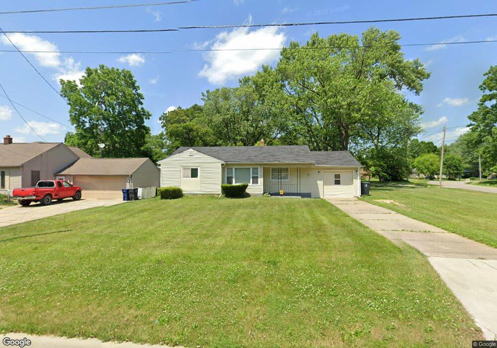
465 E Atherton Rd Flint, MI 48507
Circle Neighborhood NeighborhoodEstimated Value: $83,000 - $100,948
3
Beds
1
Bath
1,046
Sq Ft
$88/Sq Ft
Est. Value
About This Home
This home is located at 465 E Atherton Rd, Flint, MI 48507 and is currently estimated at $92,237, approximately $88 per square foot. 465 E Atherton Rd is a home located in Genesee County with nearby schools including Freeman Elementary School, Flint Southwestern Classical Academy, and Burton Glen Charter Academy.
Ownership History
Date
Name
Owned For
Owner Type
Purchase Details
Closed on
Oct 13, 2022
Sold by
Massey Morris A
Bought by
Morrmax Llc
Current Estimated Value
Purchase Details
Closed on
Aug 20, 2020
Sold by
Merrmax T Llc
Bought by
Massey Morris A and Massey Maxine M
Purchase Details
Closed on
Mar 21, 2011
Sold by
Massey Morris A and Massey Maxine M
Bought by
Morrmax T Llc
Purchase Details
Closed on
Mar 2, 2006
Sold by
Yow Jess and Yow Lilian
Bought by
Massey Morris A and Massey Maxine M
Create a Home Valuation Report for This Property
The Home Valuation Report is an in-depth analysis detailing your home's value as well as a comparison with similar homes in the area
Home Values in the Area
Average Home Value in this Area
Purchase History
| Date | Buyer | Sale Price | Title Company |
|---|---|---|---|
| Morrmax Llc | -- | -- | |
| Massey Morris A | -- | None Available | |
| Morrmax T Llc | -- | None Available | |
| Massey Morris A | $39,000 | None Available |
Source: Public Records
Tax History
| Year | Tax Paid | Tax Assessment Tax Assessment Total Assessment is a certain percentage of the fair market value that is determined by local assessors to be the total taxable value of land and additions on the property. | Land | Improvement |
|---|---|---|---|---|
| 2025 | $2,268 | $46,200 | $0 | $0 |
| 2024 | $2,075 | $41,400 | $0 | $0 |
| 2023 | $2,008 | $32,700 | $0 | $0 |
| 2022 | $0 | $27,700 | $0 | $0 |
| 2021 | $2,048 | $24,600 | $0 | $0 |
| 2020 | $1,280 | $20,500 | $0 | $0 |
| 2019 | $1,244 | $16,300 | $0 | $0 |
| 2018 | $1,254 | $17,300 | $0 | $0 |
| 2017 | $1,220 | $0 | $0 | $0 |
| 2016 | $1,211 | $0 | $0 | $0 |
| 2015 | -- | $0 | $0 | $0 |
| 2014 | -- | $0 | $0 | $0 |
| 2012 | -- | $19,400 | $0 | $0 |
Source: Public Records
Map
Nearby Homes
- 420 Burroughs Ave
- 366 E Atherton Rd
- 352 Buckingham Ave
- 4127 Custer Ave
- 326 Burroughs Ave
- 4126 Circle Dr
- 621 Burroughs Ave
- 630 Buckingham Ave
- 3914 Red Arrow Rd
- 720 Algonquin Ave
- 617 McKeighan Ave
- 530 McKeighan Ave
- 3505 Comanche Ave
- 4526 Milton Dr
- 3218 Collingwood Pkwy
- 213 E Lakeview Ave
- 4424 Cheyenne Ave
- 1030 McKeighan Ave
- 2910 Shawnee Ave
- 3110 Menominee Ave
- 459 E Atherton Rd
- 3732 Circle Dr
- 501 E Atherton Rd
- 3802 Circle Dr
- 3726 Circle Dr
- 505 E Atherton Rd
- 454 E Atherton Rd
- 502 E Atherton Rd
- 3721 Circle Dr Unit Bldg-Unit
- 3721 Circle Dr
- 507 E Atherton Rd
- 3814 Circle Dr
- 440 E Atherton Rd
- 510 E Atherton Rd
- 3720 Circle Dr
- 509 E Atherton Rd
- 443 Buckingham Ave
- 3813 Circle Dr
- 3818 Circle Dr
- 439 Buckingham Ave
Your Personal Tour Guide
Ask me questions while you tour the home.