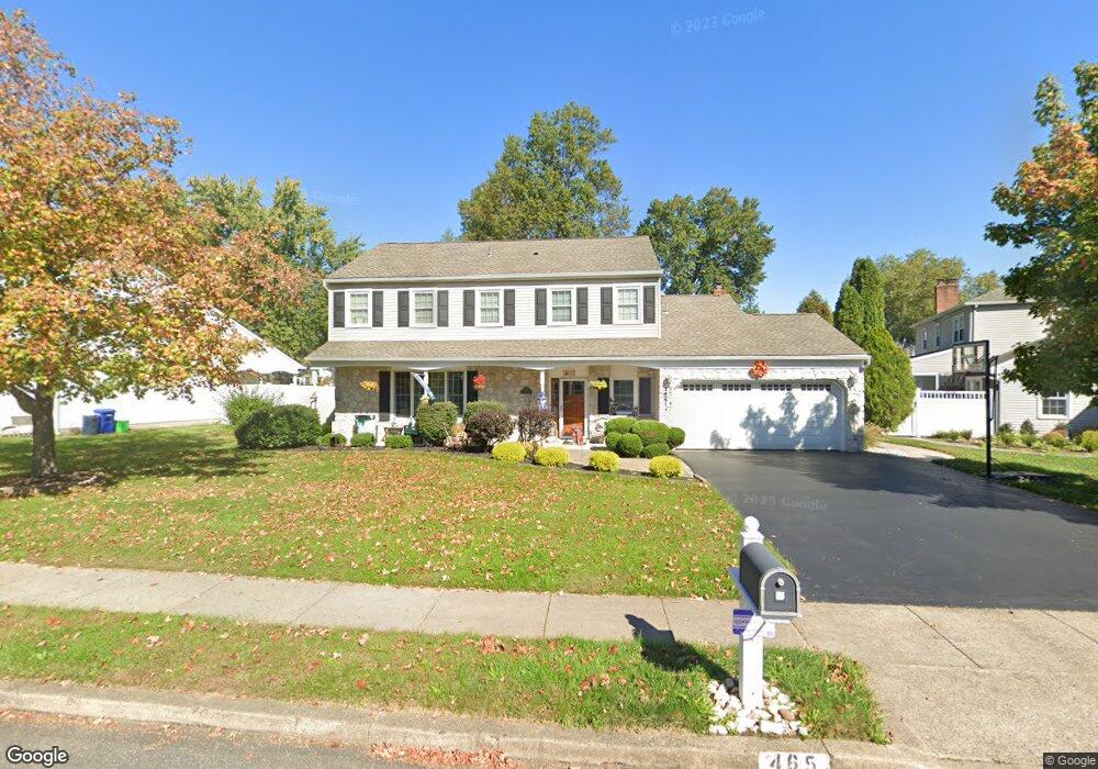
465 Maple Point Dr Langhorne, PA 19047
Estimated Value: $707,046 - $780,000
4
Beds
3
Baths
2,348
Sq Ft
$318/Sq Ft
Est. Value
About This Home
This home is located at 465 Maple Point Dr, Langhorne, PA 19047 and is currently estimated at $746,262, approximately $317 per square foot. 465 Maple Point Dr is a home located in Bucks County with nearby schools including Pearl S. Buck Elementary School, Maple Point Middle School, and Neshaminy High School.
Ownership History
Date
Name
Owned For
Owner Type
Purchase Details
Closed on
Mar 17, 2006
Sold by
Mix Dean G and Mix Meghan S
Bought by
Kindness George Scott and Kindness Jeannine S
Current Estimated Value
Home Financials for this Owner
Home Financials are based on the most recent Mortgage that was taken out on this home.
Original Mortgage
$280,000
Interest Rate
6.48%
Mortgage Type
Purchase Money Mortgage
Create a Home Valuation Report for This Property
The Home Valuation Report is an in-depth analysis detailing your home's value as well as a comparison with similar homes in the area
Home Values in the Area
Average Home Value in this Area
Purchase History
We collect this data history from publicly available records. To have your information removed, we recommend requesting removal directly through your county’s website.
| Date | Buyer | Sale Price | Title Company |
|---|---|---|---|
| Kindness George Scott | $469,900 | None Available |
Source: Public Records
Mortgage History
We collect this data history from publicly available records. To have your information removed, we recommend requesting removal directly through your county’s website.
| Date | Status | Borrower | Loan Amount |
|---|---|---|---|
| Previous Owner | Kindness George Scott | $280,000 |
Source: Public Records
Tax History
| Year | Tax Paid | Tax Assessment Tax Assessment Total Assessment is a certain percentage of the fair market value that is determined by local assessors to be the total taxable value of land and additions on the property. | Land | Improvement |
|---|---|---|---|---|
| 2026 | $9,491 | $41,600 | $6,760 | $34,840 |
| 2025 | $9,057 | $41,600 | $6,760 | $34,840 |
| 2024 | $9,057 | $41,600 | $6,760 | $34,840 |
| 2023 | $8,913 | $41,600 | $6,760 | $34,840 |
| 2022 | $8,679 | $41,600 | $6,760 | $34,840 |
| 2021 | $8,679 | $41,600 | $6,760 | $34,840 |
| 2020 | $8,575 | $41,600 | $6,760 | $34,840 |
| 2019 | $8,383 | $41,600 | $6,760 | $34,840 |
| 2018 | $8,229 | $41,600 | $6,760 | $34,840 |
| 2017 | $8,019 | $41,600 | $6,760 | $34,840 |
| 2016 | $8,019 | $41,600 | $6,760 | $34,840 |
| 2015 | $8,209 | $41,600 | $6,760 | $34,840 |
| 2014 | $8,209 | $41,600 | $6,760 | $34,840 |
Source: Public Records
Map
Nearby Homes
- 14304 Cornerstone Dr Unit 169
- 1004 Waterford Rd
- 302 Mallard Ln
- 444 Briggs Rd
- 476 Gladstone Rd
- 2607 Lynbrooke Dr
- 559 Palmer Farm Dr
- 2402 Waterford Rd Unit 94
- 8504 Spruce Mill Dr Unit 707
- 2203 Waterford Rd Unit 86
- 415 Chestnut Ct
- 475 Franklin Cir
- 9408 Sheffield Dr Unit 575
- 548 Palmer Farm Dr
- 7403 Spruce Mill Dr Unit 582
- 2104 Brookhaven Dr Unit 290
- 183 Fillmore Way
- 1921 Kirkbride Cir
- 4202 Waltham Ct Unit 270
- 1693 Pierce Way
- 590 Atkinson Ln
- 570 Atkinson Ln
- 600 Atkinson Ln
- 495 Maple Point Dr
- 610 Atkinson Ln
- 571 Atkinson Ln
- 591 Atkinson Ln
- 601 Atkinson Ln
- 581 Atkinson Ln
- 505 Maple Point Dr
- 611 Atkinson Ln
- 620 Atkinson Ln
- 621 Atkinson Ln
- 484 Maple Point Dr
- 515 Maple Point Dr
- 633 Croasdale Dr
- 476 Trappe Ln
- 486 Trappe Ln
- 466 Trappe Ln
- 455 Maple Point Dr
Your Personal Tour Guide
Ask me questions while you tour the home.