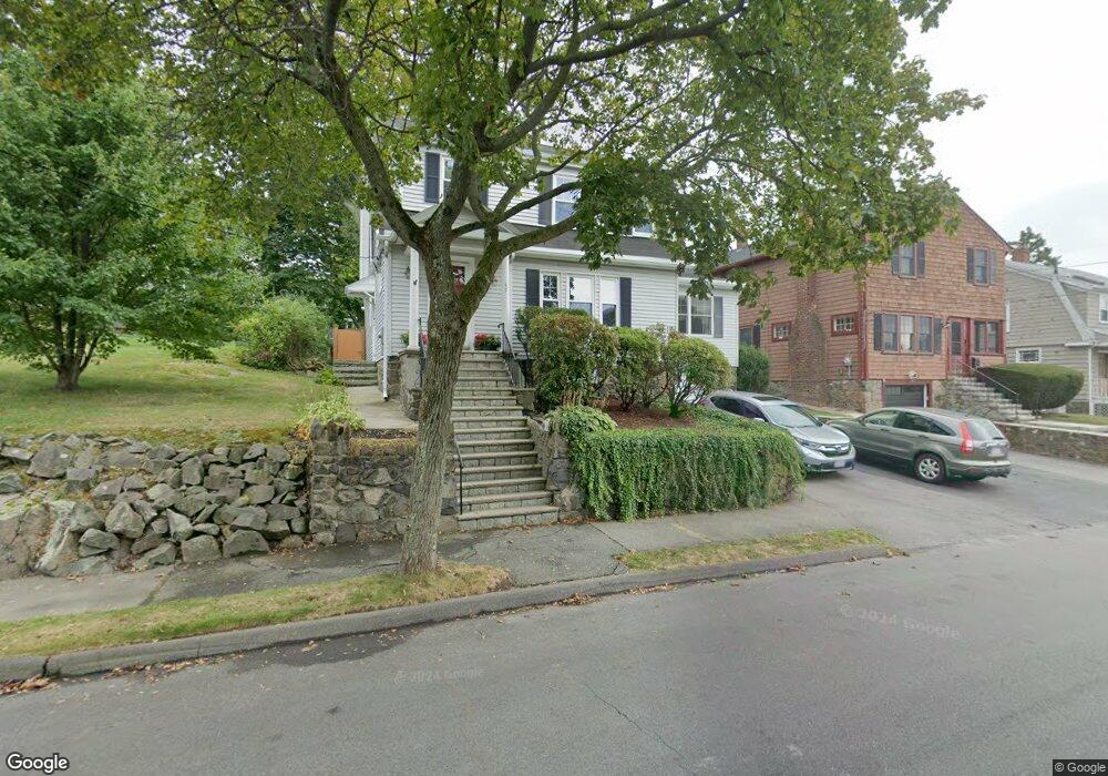
47 Barnstable St Swampscott, MA 01907
Estimated Value: $779,000 - $832,349
About This Home
This home is located at 47 Barnstable St, Swampscott, MA 01907 and is currently estimated at $805,587, approximately $367 per square foot. 47 Barnstable St is a home located in Essex County with nearby schools including Swampscott Middle School and Swampscott High School.
Ownership History
We collect this data history from publicly available records. To have your information removed, we recommend requesting removal directly through your county’s website.
Purchase Details
Purchase Details
Purchase Details
Purchase Details
Home Values in the Area
Average Home Value in this Area
Purchase History
We collect this data history from publicly available records. To have your information removed, we recommend requesting removal directly through your county’s website.
| Date | Buyer | Sale Price | Title Company |
|---|---|---|---|
| -- | -- | ||
| $275,000 | -- | ||
| $228,500 | -- | ||
| $225,000 | -- |
Mortgage History
We collect this data history from publicly available records. To have your information removed, we recommend requesting removal directly through your county’s website.
| Date | Status | Borrower | Loan Amount |
|---|---|---|---|
| Closed | $25,000 | ||
| Closed | $170,000 | ||
| Closed | $197,000 | ||
| Closed | $197,000 | ||
| Closed | $25,000 | ||
| Closed | $200,000 | ||
| Closed | $170,900 | ||
| Closed | $156,000 |
Tax History
We collect this data history from publicly available records. To have your information removed, we recommend requesting removal directly through your county’s website.
| Year | Tax Paid | Tax Assessment Tax Assessment Total Assessment is a certain percentage of the fair market value that is determined by local assessors to be the total taxable value of land and additions on the property. | Land | Improvement |
|---|---|---|---|---|
| 2025 | $7,583 | $661,100 | $288,700 | $372,400 |
| 2024 | $7,416 | $645,400 | $276,300 | $369,100 |
| 2023 | $7,105 | $605,200 | $263,900 | $341,300 |
| 2022 | $6,767 | $527,400 | $230,900 | $296,500 |
| 2021 | $6,959 | $504,300 | $214,400 | $289,900 |
| 2020 | $6,737 | $471,100 | $185,600 | $285,500 |
| 2019 | $6,471 | $425,700 | $140,200 | $285,500 |
| 2018 | $6,326 | $395,400 | $132,000 | $263,400 |
| 2017 | $6,369 | $365,000 | $123,700 | $241,300 |
| 2016 | $6,325 | $365,000 | $123,700 | $241,300 |
| 2015 | $6,119 | $356,800 | $115,500 | $241,300 |
| 2014 | $6,448 | $344,800 | $132,000 | $212,800 |
Map
- 10-12 Fairview Ave
- 29 Ellis Rd
- 246 Burrill St
- 5 Lexington Park
- 2 Ellis Terrace
- 21 Capstan Way Unit 37
- 6 Elmwood Rd
- 161 Burrill St
- 3 Gooseneck Ln Unit 127
- 143 Burrill St Unit 301
- 143 Burrill St Unit 102
- 9 Sheridan Rd
- 404 Paradise Rd Unit 1D
- 404 Paradise Rd Unit 1C
- 404 Paradise Rd Unit 1P
- 22 Beach Ave
- 4 Clark St
- 67 Beach Ave
- 402 Paradise Rd Unit U: 3Q
- 8 Essex St
- 43 Barnstable St
- 39 Barnstable St
- 44 Barnstable St
- 40 Barnstable St
- 4 Plymouth Ave
- 10 Hampshire St
- 12 Plymouth Ave
- 36 Barnstable St
- 14 Hampshire St
- 48 Barnstable St
- 32 Barnstable St
- 14 Plymouth Ave
- 20 Hampshire St
- 111 Stetson Ave Unit 111A
- 7 Plymouth Ave
- 107 Stetson Ave
- 3 Plymouth Ave
- 113 Stetson Ave Unit 115
- 28 Barnstable St
- 103 Stetson Ave
Ask me questions while you tour the home.