47 Chapman Ave Westbrook, CT 06498
Estimated Value: $958,000 - $1,821,000
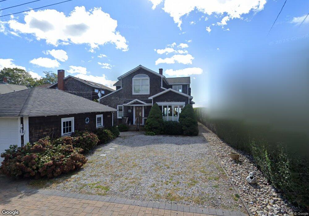
About This Home
This home is located at 47 Chapman Ave, Westbrook, CT 06498 and is currently estimated at $1,457,566, approximately $506 per square foot. 47 Chapman Ave is a home located in Middlesex County with nearby schools including Daisy Ingraham School, Westbrook Middle School, and Westbrook High School.
Ownership History
We collect this data history from publicly available records. To have your information removed, we recommend requesting removal directly through your county’s website.
Purchase Details
Purchase Details
Home Financials for this Owner
Home Financials are based on the most recent Mortgage that was taken out on this home.Home Values in the Area
Average Home Value in this Area
Purchase History
We collect this data history from publicly available records. To have your information removed, we recommend requesting removal directly through your county’s website.
| Date | Buyer | Sale Price | Title Company |
|---|---|---|---|
| -- | -- | ||
| -- | -- | ||
| $275,000 | -- |
Mortgage History
We collect this data history from publicly available records. To have your information removed, we recommend requesting removal directly through your county’s website.
| Date | Status | Borrower | Loan Amount |
|---|---|---|---|
| Previous Owner | $175,000 | ||
| Previous Owner | $175,000 |
Tax History
We collect this data history from publicly available records. To have your information removed, we recommend requesting removal directly through your county’s website.
| Year | Tax Paid | Tax Assessment Tax Assessment Total Assessment is a certain percentage of the fair market value that is determined by local assessors to be the total taxable value of land and additions on the property. | Land | Improvement |
|---|---|---|---|---|
| 2025 | $17,220 | $765,320 | $558,300 | $207,020 |
| 2024 | $16,607 | $765,320 | $558,300 | $207,020 |
| 2023 | $16,317 | $765,320 | $558,300 | $207,020 |
| 2022 | $15,888 | $765,320 | $558,300 | $207,020 |
| 2021 | $16,810 | $672,390 | $477,120 | $195,270 |
| 2020 | $16,810 | $672,390 | $477,120 | $195,270 |
| 2019 | $16,588 | $672,390 | $477,120 | $195,270 |
| 2018 | $16,386 | $672,390 | $477,120 | $195,270 |
| 2017 | $16,386 | $672,390 | $477,120 | $195,270 |
| 2016 | $17,474 | $755,160 | $551,340 | $203,820 |
| 2015 | $16,999 | $755,160 | $551,340 | $203,820 |
| 2014 | $16,455 | $755,160 | $551,340 | $203,820 |
Map
- 9 2nd Ave
- 118 Sandy Point Rd
- 256 Hidden Cove Rd
- 4 Beach Rd
- 5 Cook Terrace
- 96 Chalker Beach Rd
- 13 Green Acres Park Dr
- 52 Chalker Beach Rd
- 100 2nd Ave
- 19 Old Forge Rd
- 23 Meadowood Ln
- 1445 Boston Post Rd
- 8 Owaneco Trail
- 1405-1445 Boston Post Rd
- 1333 Boston Post Rd Unit 1
- 95 Middletown Ave
- 224 Salt Island Rd
- 39 Middletown Ave
- 2 Captains Ln
- 25 River Ave
Ask me questions while you tour the home.