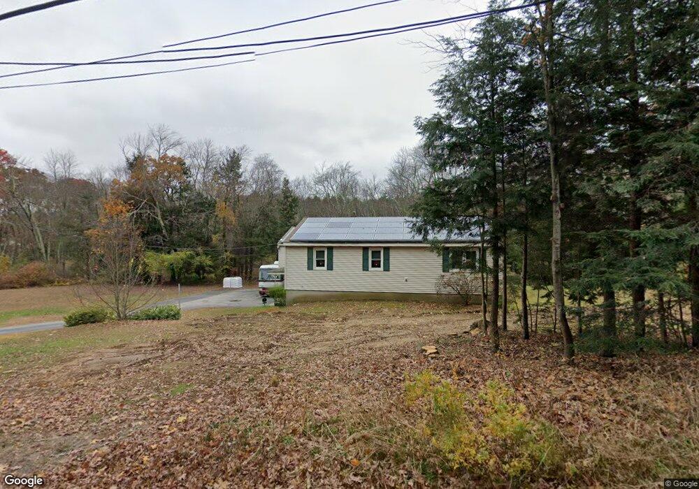
470 Hartford Ave E Uxbridge, MA 01569
Estimated Value: $647,315 - $685,000
3
Beds
2
Baths
2,920
Sq Ft
$227/Sq Ft
Est. Value
About This Home
This home is located at 470 Hartford Ave E, Uxbridge, MA 01569 and is currently estimated at $663,579, approximately $227 per square foot. 470 Hartford Ave E is a home located in Worcester County with nearby schools including Uxbridge High School, Our Lady of the Valley Regional School, and Whitinsville Christian School.
Ownership History
Date
Name
Owned For
Owner Type
Purchase Details
Closed on
May 28, 2009
Sold by
Bartlett Bette J
Bought by
Bartlett Joseph and Bartlett Bette J
Current Estimated Value
Home Financials for this Owner
Home Financials are based on the most recent Mortgage that was taken out on this home.
Original Mortgage
$332,200
Outstanding Balance
$211,018
Interest Rate
4.87%
Mortgage Type
Purchase Money Mortgage
Estimated Equity
$452,561
Create a Home Valuation Report for This Property
The Home Valuation Report is an in-depth analysis detailing your home's value as well as a comparison with similar homes in the area
Home Values in the Area
Average Home Value in this Area
Purchase History
We collect this data history from publicly available records. To have your information removed, we recommend requesting removal directly through your county’s website.
| Date | Buyer | Sale Price | Title Company |
|---|---|---|---|
| Bartlett Joseph | -- | -- |
Source: Public Records
Mortgage History
We collect this data history from publicly available records. To have your information removed, we recommend requesting removal directly through your county’s website.
| Date | Status | Borrower | Loan Amount |
|---|---|---|---|
| Open | Bartlett Joseph | $332,200 |
Source: Public Records
Tax History
| Year | Tax Paid | Tax Assessment Tax Assessment Total Assessment is a certain percentage of the fair market value that is determined by local assessors to be the total taxable value of land and additions on the property. | Land | Improvement |
|---|---|---|---|---|
| 2025 | $6,391 | $487,500 | $128,100 | $359,400 |
| 2024 | $6,162 | $476,900 | $117,500 | $359,400 |
| 2023 | $5,968 | $427,800 | $106,700 | $321,100 |
| 2022 | $5,711 | $376,700 | $96,800 | $279,900 |
| 2021 | $5,891 | $372,400 | $92,500 | $279,900 |
| 2020 | $5,260 | $314,200 | $96,100 | $218,100 |
| 2019 | $5,261 | $303,200 | $89,000 | $214,200 |
| 2018 | $4,928 | $287,000 | $89,000 | $198,000 |
| 2017 | $5,168 | $304,700 | $84,000 | $220,700 |
| 2016 | $5,187 | $295,200 | $86,300 | $208,900 |
| 2015 | $5,023 | $288,700 | $86,300 | $202,400 |
Source: Public Records
Map
Nearby Homes
- 12 Pinecrest Rd Unit B
- 123 Carrington Ln Unit 123
- 72 Arthur Dr Unit 72
- 298 Providence Rd
- 41 Church St
- 3 Strathmore Shire Unit E
- 29 Thornton St
- 3 Moon Hill Rd
- 11 Boston St
- 30 Glendale Ave
- 223 Heritage Dr
- 17 Park St
- 9 Jewell Crossing
- 13 Valerie Run
- 138 Elm St
- 11 Marion St
- 179 South St
- 173 Rolling Ridge Dr Unit 99
- 117 Saint Andre Dr
- 48 Crestwood Cir Unit 26
- 473 Hartford Ave E
- 465 Hartford Ave E
- 480 Hartford Ave E
- 450 E Hartford Ave
- 488 E Hartford Ave
- 10 Serenity Dr
- 86 My Way
- 499 E Hartford Ave
- 442 Hartford Ave E
- 11 Serenity Dr
- 445 E Hartford Ave
- 20 Serenity Dr
- 76 My Way
- 89 My Way
- 505 E Hartford Ave
- 66 My Way
- 2 Donna Dr Unit 2
- 500 E Hartford Ave
- 432 E Hartford Ave
- 15 Wendy Way
Your Personal Tour Guide
Ask me questions while you tour the home.