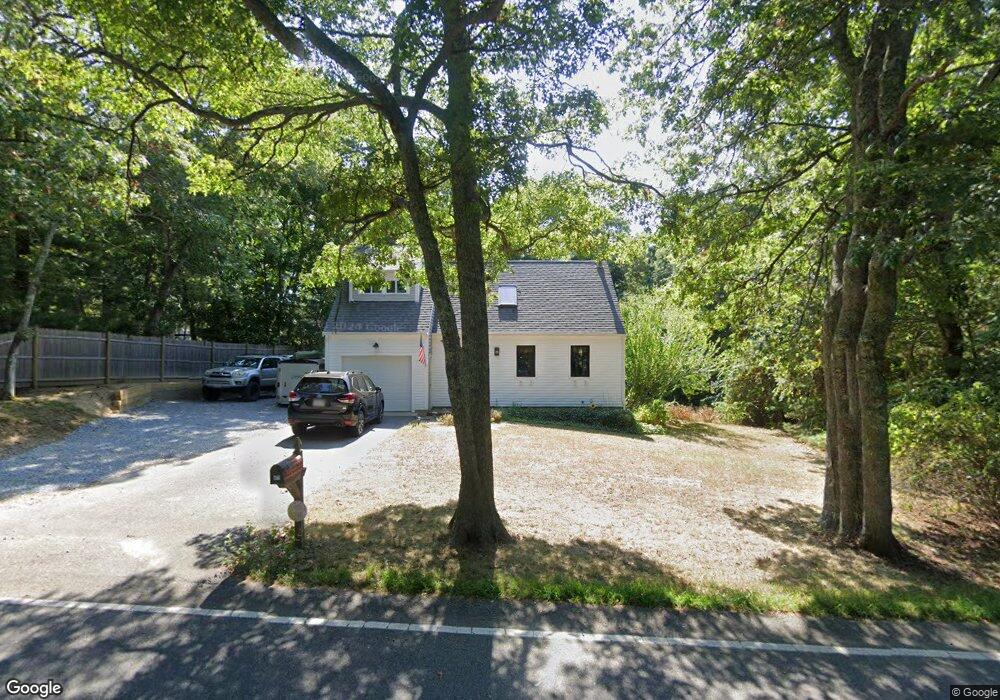
471 Flint St Marstons Mills, MA 02648
Marstons Mills NeighborhoodEstimated Value: $546,000 - $622,000
3
Beds
2
Baths
936
Sq Ft
$636/Sq Ft
Est. Value
About This Home
This home is located at 471 Flint St, Marstons Mills, MA 02648 and is currently estimated at $595,464, approximately $636 per square foot. 471 Flint St is a home located in Barnstable County with nearby schools including West Villages Elementary School, Barnstable United Elementary School, and Barnstable Intermediate School.
Ownership History
Date
Name
Owned For
Owner Type
Purchase Details
Closed on
Dec 28, 2011
Sold by
Dixon Matthew and Dixon Rachel A
Bought by
Dwyer Margaret
Current Estimated Value
Home Financials for this Owner
Home Financials are based on the most recent Mortgage that was taken out on this home.
Original Mortgage
$209,000
Outstanding Balance
$161,628
Interest Rate
4%
Mortgage Type
Purchase Money Mortgage
Estimated Equity
$433,836
Purchase Details
Closed on
Aug 27, 2001
Sold by
Packard Michael and Packard Deborah C
Bought by
Dixon Matthew and Dixon Rachel A
Home Financials for this Owner
Home Financials are based on the most recent Mortgage that was taken out on this home.
Original Mortgage
$169,322
Interest Rate
7.21%
Mortgage Type
Purchase Money Mortgage
Purchase Details
Closed on
Sep 17, 1993
Sold by
Secty Veterans Affairs
Bought by
Packard Michael and Packard Deborah C
Purchase Details
Closed on
Nov 18, 1992
Sold by
Griffin James
Bought by
Resolution Trust Corp
Purchase Details
Closed on
Aug 25, 1989
Sold by
Gilbert Jean
Bought by
Griffin James
Create a Home Valuation Report for This Property
The Home Valuation Report is an in-depth analysis detailing your home's value as well as a comparison with similar homes in the area
Home Values in the Area
Average Home Value in this Area
Purchase History
We collect this data history from publicly available records. To have your information removed, we recommend requesting removal directly through your county’s website.
| Date | Buyer | Sale Price | Title Company |
|---|---|---|---|
| Dwyer Margaret | $205,000 | -- | |
| Dwyer Margaret | $205,000 | -- | |
| Dixon Matthew | $173,000 | -- | |
| Packard Michael | $88,500 | -- | |
| Resolution Trust Corp | $73,920 | -- | |
| Griffin James | $116,650 | -- |
Source: Public Records
Mortgage History
We collect this data history from publicly available records. To have your information removed, we recommend requesting removal directly through your county’s website.
| Date | Status | Borrower | Loan Amount |
|---|---|---|---|
| Open | Dwyer Margaret | $209,000 | |
| Closed | Griffin James | $209,000 | |
| Previous Owner | Griffin James | $170,000 | |
| Previous Owner | Griffin James | $169,322 |
Source: Public Records
Tax History
| Year | Tax Paid | Tax Assessment Tax Assessment Total Assessment is a certain percentage of the fair market value that is determined by local assessors to be the total taxable value of land and additions on the property. | Land | Improvement |
|---|---|---|---|---|
| 2025 | $3,971 | $490,900 | $155,900 | $335,000 |
| 2024 | $3,664 | $469,200 | $155,900 | $313,300 |
| 2023 | $3,499 | $419,600 | $141,700 | $277,900 |
| 2022 | $3,289 | $341,200 | $105,000 | $236,200 |
| 2021 | $3,041 | $309,000 | $105,000 | $204,000 |
| 2020 | $3,291 | $300,300 | $105,000 | $195,300 |
| 2019 | $2,647 | $234,700 | $105,000 | $129,700 |
| 2018 | $2,689 | $223,500 | $110,500 | $113,000 |
| 2017 | $2,641 | $218,600 | $110,500 | $108,100 |
| 2016 | $2,394 | $219,600 | $111,500 | $108,100 |
| 2015 | $2,314 | $213,300 | $109,000 | $104,300 |
Source: Public Records
Map
Nearby Homes
- 50 Samoset Rd
- 50 Samoset Rd
- 5 Raspberry Ln
- 251 Lakeside Dr
- 192 Sandy Valley Rd
- 9 Mansfield Ave
- 24 Starlight Dr
- 105 Nelson Ln
- 51 Rhody Cir
- 817 Race Ln
- 23 Captain Baker Rd
- 57 Fairhaven Ln
- 8 Brigantine Ave
- 47 May Ln
- 988 Old Falmouth Rd
- 55 Seth Goodspeed Way
- 53 Hadrada Ln
- 1020 Old Falmouth Rd
- 169 Cedric Rd
- 303 Turtleback Rd
Your Personal Tour Guide
Ask me questions while you tour the home.