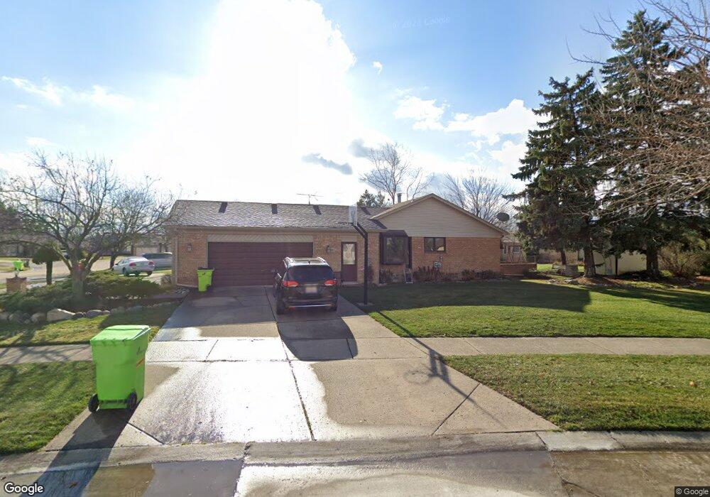
47355 Nola Dr Macomb, MI 48044
Estimated Value: $376,301 - $415,000
4
Beds
3
Baths
2,411
Sq Ft
$164/Sq Ft
Est. Value
About This Home
This home is located at 47355 Nola Dr, Macomb, MI 48044 and is currently estimated at $395,325, approximately $163 per square foot. 47355 Nola Dr is a home located in Macomb County with nearby schools including Mohawk Elementary School, Iroquois Middle School, and Dakota High School.
Ownership History
Date
Name
Owned For
Owner Type
Purchase Details
Closed on
Sep 19, 2017
Sold by
Golitko Larry J and Golitko Janice M
Bought by
Golitko Larry J and Golitko Janice M
Current Estimated Value
Purchase Details
Closed on
Jan 2, 2001
Sold by
Biundo Salvatore A
Bought by
Pampu Emilian
Home Financials for this Owner
Home Financials are based on the most recent Mortgage that was taken out on this home.
Original Mortgage
$159,101
Interest Rate
7.03%
Mortgage Type
Purchase Money Mortgage
Purchase Details
Closed on
Oct 1, 1999
Sold by
Golitko Larry J
Bought by
Biundo Salvatore A
Create a Home Valuation Report for This Property
The Home Valuation Report is an in-depth analysis detailing your home's value as well as a comparison with similar homes in the area
Home Values in the Area
Average Home Value in this Area
Purchase History
We collect this data history from publicly available records. To have your information removed, we recommend requesting removal directly through your county’s website.
| Date | Buyer | Sale Price | Title Company |
|---|---|---|---|
| Golitko Larry J | -- | None Available | |
| Pampu Emilian | $202,000 | -- | |
| Biundo Salvatore A | $51,000 | -- |
Source: Public Records
Mortgage History
We collect this data history from publicly available records. To have your information removed, we recommend requesting removal directly through your county’s website.
| Date | Status | Borrower | Loan Amount |
|---|---|---|---|
| Previous Owner | Pampu Emilian | $159,101 |
Source: Public Records
Tax History
| Year | Tax Paid | Tax Assessment Tax Assessment Total Assessment is a certain percentage of the fair market value that is determined by local assessors to be the total taxable value of land and additions on the property. | Land | Improvement |
|---|---|---|---|---|
| 2025 | $2,710 | $180,900 | $0 | $0 |
| 2024 | $26 | $174,400 | $0 | $0 |
| 2023 | $2,499 | $164,900 | $0 | $0 |
| 2022 | $3,104 | $149,800 | $0 | $0 |
| 2021 | $3,008 | $138,800 | $0 | $0 |
| 2020 | $2,283 | $130,400 | $0 | $0 |
| 2019 | $2,782 | $120,100 | $0 | $0 |
| 2018 | $2,711 | $118,700 | $0 | $0 |
| 2017 | $2,668 | $114,240 | $29,500 | $84,740 |
| 2016 | $2,531 | $114,240 | $0 | $0 |
| 2015 | $2,497 | $104,650 | $0 | $0 |
| 2014 | $2,497 | $86,820 | $20,500 | $66,320 |
| 2013 | $1,846 | $86,820 | $0 | $0 |
Source: Public Records
Map
Nearby Homes
- 47038 Sarnus Dr
- 47726 Lexington Dr
- 46980 Country Ln Unit 8
- 46972 Mckenna Dr
- 17115 Scarborough Dr Unit 562
- 18169 Riverhill Dr
- 47651 Chrys Rd
- 17128 Scarborough Dr
- 46721 Peach Grove Ave
- 47701 Concord Rd
- 17385 Hillcrest Dr
- 48037 Lafayette Dr
- 46561 Plum Grove Dr
- 48199 Lafayette Dr
- 46101 Allenton Dr
- 15995 Quail Ct
- 16832 Glenmoor Blvd
- 48528 Lafayette Dr
- 46519 Donahue Ave
- 46700 Tilch Rd
Your Personal Tour Guide
Ask me questions while you tour the home.