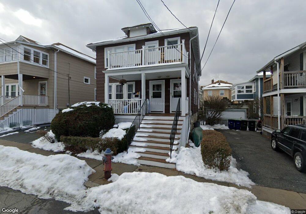
48 Chetwynd Rd Somerville, MA 02144
West Somerville NeighborhoodEstimated Value: $1,012,000 - $1,296,516
4
Beds
2
Baths
2,300
Sq Ft
$518/Sq Ft
Est. Value
About This Home
This home is located at 48 Chetwynd Rd, Somerville, MA 02144 and is currently estimated at $1,190,379, approximately $517 per square foot. 48 Chetwynd Rd is a home located in Middlesex County with nearby schools including Somerville High School, St. Clement Elementary School, and International School of Boston.
Ownership History
Date
Name
Owned For
Owner Type
Purchase Details
Closed on
Jun 17, 2020
Sold by
Murphy Philip F and Murphy Darlene M
Bought by
Chetwynd Road T
Current Estimated Value
Purchase Details
Closed on
Jul 1, 1983
Bought by
Murphy Philip F and Murphy Darlene M
Create a Home Valuation Report for This Property
The Home Valuation Report is an in-depth analysis detailing your home's value as well as a comparison with similar homes in the area
Home Values in the Area
Average Home Value in this Area
Purchase History
| Date | Buyer | Sale Price | Title Company |
|---|---|---|---|
| Chetwynd Road T | -- | None Available | |
| Murphy Philip F | $90,000 | -- |
Source: Public Records
Mortgage History
| Date | Status | Borrower | Loan Amount |
|---|---|---|---|
| Previous Owner | Murphy Philip F | $80,000 |
Source: Public Records
Tax History
| Year | Tax Paid | Tax Assessment Tax Assessment Total Assessment is a certain percentage of the fair market value that is determined by local assessors to be the total taxable value of land and additions on the property. | Land | Improvement |
|---|---|---|---|---|
| 2025 | $10,507 | $963,100 | $540,100 | $423,000 |
| 2024 | $9,897 | $940,800 | $540,100 | $400,700 |
| 2023 | $9,659 | $934,100 | $540,100 | $394,000 |
| 2022 | $8,908 | $875,000 | $514,400 | $360,600 |
| 2021 | $8,674 | $851,200 | $510,600 | $340,600 |
| 2020 | $8,524 | $844,800 | $510,900 | $333,900 |
| 2019 | $7,999 | $743,400 | $465,100 | $278,300 |
| 2018 | $7,746 | $684,900 | $422,800 | $262,100 |
| 2017 | $7,452 | $638,600 | $398,900 | $239,700 |
| 2016 | $7,636 | $609,400 | $356,300 | $253,100 |
| 2015 | $7,284 | $577,600 | $329,000 | $248,600 |
Source: Public Records
Map
Nearby Homes
- 183 Powder House Blvd
- 12 Upland Rd
- 25 Upland Rd
- 123 W Adams St Unit 1
- 83 Conwell Ave Unit 1
- 202 Powder House Blvd Unit 1
- 202 Powder House Blvd Unit 2
- 233 Powder House Blvd
- 34 Belknap St
- 138 North St
- 6 Hamilton Rd Unit 6
- 150 North St Unit 150
- 106 Electric Ave Unit 3
- 55 Packard Ave Unit 1
- 42 Packard Ave Unit 42
- 1252 Broadway Unit 4
- 1188 Broadway Unit 403
- 14 Farragut Ave Unit 1
- 59A High St Unit A
- 325A Alewife Brook Pkwy Unit A
- 48 Chetwynd Rd Unit 1
- 46 Chetwynd Rd
- 126 Hillsdale Rd
- 130 Hillsdale Rd
- 130 Hillsdale Rd Unit 2
- 128 Hillsdale Rd
- 124/126 Hillsdale Rd Unit 1
- 124/126 Hillsdale Rd
- 124 Hillsdale Rd
- 44 Chetwynd Rd
- 44 Chetwynd Rd Unit 2
- 44 Chetwynd Rd Unit 1
- 47 Curtis Ave
- 49 Curtis Ave
- 49 Curtis Ave Unit 2
- 51 Curtis Ave
- 43 Curtis Ave
- 41 Curtis Ave Unit 41
- 41 Curtis Ave
- 41 Curtis Ave Unit 1
Your Personal Tour Guide
Ask me questions while you tour the home.