
Landlord's Agent in 2026
Brian Van Hoven
AGS Browning Realty
(703) 906-6832
5 in this area
37 Total Sales


Estimated Value: $533,000 - $720,364
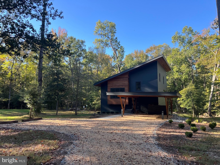
Look no further this brand new contemporary home is ready for immediate move in. This home sits on two acres surrounded by trees and is adjoining a 1,000 acre State Park. Home features 3 finished levels, 4 bedrooms, 4 full bathrooms, carport, large composite deck 12x18 off kitchen/dining area and covered storage area. Upper level has a multipurpose room with separate full bath and large walk-in storage room. This room could be an additonal bedroom with addition of a closet. There is an enlarged stair landing area beteween main and upper level that has a built in desk for a personal office use. Main level with an open concept. Lots of natural light from the living room and kitchen. Living room has exposed beams. Kitchen has plenty of countertop space and cabinets with a large island. Just off the kitchen in a walk-in pantry with an addtional sink and dishwasher. There is a large deck off the kitchen that with great views and would be prefect for get-togethers. Primary bedroom with additional dressing area, walk-in & second closet and attached bathroom with walk-in shower. Lower level recreation room with small kitchen, 3 bedrooms, 2 full baths, laundry room with front loading washer, dryer and sink and countertop to fold laundry. Main and upper level have solid wood floors and the lower level has stained concrete flooring. Additonal features; laundry shoot, energy star heating/cooling heat pump systems with continuous fresh air, engineered and solid wood siding, locally grown wood flooring. The home is super insulated with continuous 3" exterior rigid insulation. House was blower door tested prior to installation of cavity wall insulation and this have very few air leaks, this will keep your heating and cooling cost down. Each floor has individual heat pump mechanical systems. The entire house had an energy recovery ventilation system to provide continuouis fresh air ventilation. No HOA!
Last Agent to Rent the Property
(540) 659-1617 bvanhovenrealtor@gmail.com AGS Browning Realty Brokerage Phone: 5406591617 License #0225079627 Listed on: 10/22/2025
Last Renter's Agent
(540) 659-1617 bvanhovenrealtor@gmail.com AGS Browning Realty Brokerage Phone: 5406591617 License #0225079627 Listed on: 10/22/2025
We collect this data history from publicly available records. To have your information removed, we recommend requesting removal directly through your county’s website.
| Date | Buyer | Sale Price | Title Company |
|---|---|---|---|
| Rust Family Trust | -- | None Listed On Document | |
| Rust John W | $105,000 | Kensington Vanguard | |
| Hott Austin R | $180,000 | -- |
We collect this data history from publicly available records. To have your information removed, we recommend requesting removal directly through your county’s website.
| Date | Status | Borrower | Loan Amount |
|---|---|---|---|
| Previous Owner | Hott Austin R | $144,000 |
| Date | Event | Price | List to Sale | Price per Sq Ft |
|---|---|---|---|---|
| 05/01/2026 05/01/26 | Rented | $3,500 | 0.0% | -- |
| 03/31/2026 03/31/26 | Under Contract | -- | -- | -- |
| 03/12/2026 03/12/26 | Price Changed | $3,500 | -22.2% | $1 / Sq Ft |
| 10/22/2025 10/22/25 | For Rent | $4,500 | -- | -- |
| Year | Tax Paid | Tax Assessment Tax Assessment Total Assessment is a certain percentage of the fair market value that is determined by local assessors to be the total taxable value of land and additions on the property. | Land | Improvement |
|---|---|---|---|---|
| 2025 | $1,087 | $388,200 | $195,000 | $193,200 |
| 2024 | $1,087 | $320,000 | $195,000 | $125,000 |
| 2023 | $1,087 | $115,000 | $115,000 | $0 |
| 2022 | $978 | $115,000 | $115,000 | $0 |
| 2021 | $1,116 | $115,000 | $115,000 | $0 |
| 2020 | $1,116 | $115,000 | $115,000 | $0 |
| 2019 | $1,162 | $115,000 | $115,000 | $0 |
| 2018 | $1,139 | $115,000 | $115,000 | $0 |
| 2017 | $1,139 | $115,000 | $115,000 | $0 |
| 2016 | $1,139 | $115,000 | $115,000 | $0 |
| 2015 | -- | $115,000 | $115,000 | $0 |
| 2014 | -- | $115,000 | $115,000 | $0 |
Landlord's Agent in 2026
Brian Van Hoven
AGS Browning Realty
(703) 906-6832
5 in this area
37 Total Sales
Source: Bright MLS
MLS Number: VAST2043606
APN: 32A-2-5
Disclaimer: Certain information contained herein is derived from information provided by parties other than Homes.com. All information provided is deemed reliable, but is not guaranteed to be accurate and should be independently verified.
![]() The data relating to real estate for sale on this website appears in part through the BRIGHT Internet Data Exchange program, a voluntary cooperative exchange of property listing data between licensed real estate brokerage firms, and is provided by BRIGHT through a licensing agreement.
The data relating to real estate for sale on this website appears in part through the BRIGHT Internet Data Exchange program, a voluntary cooperative exchange of property listing data between licensed real estate brokerage firms, and is provided by BRIGHT through a licensing agreement.
Listing information is from various brokers who participate in the Bright MLS IDX program and not all listings may be visible on the site.
The property information being provided on or through the website is for the personal, non-commercial use of consumers and such information may not be used for any purpose other than to identify prospective properties consumers may be interested in purchasing.
Some properties which appear for sale on the website may no longer be available because they are for instance, under contract, sold or are no longer being offered for sale.
Property information displayed is deemed reliable but is not guaranteed.
Copyright 2026 Bright MLS, Inc.
Ask me questions while you tour the home.