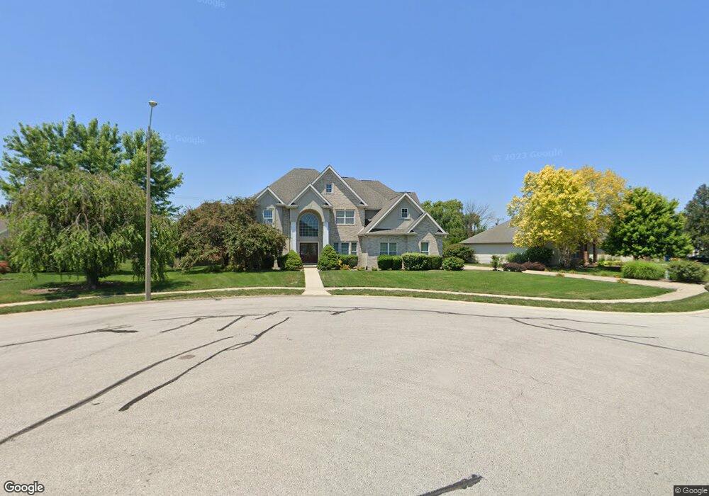
4809 Bears Paw Springfield, IL 62711
Estimated Value: $514,674 - $889,000
5
Beds
6
Baths
5,403
Sq Ft
$127/Sq Ft
Est. Value
About This Home
This home is located at 4809 Bears Paw, Springfield, IL 62711 and is currently estimated at $688,225, approximately $127 per square foot. 4809 Bears Paw is a home located in Sangamon County with nearby schools including Chatham Elementary School, Glenwood Middle School, and Glenwood Intermediate School.
Ownership History
Date
Name
Owned For
Owner Type
Purchase Details
Closed on
Feb 19, 2021
Sold by
Ghanta Koteswara Rao and Ghanta Bhavani
Bought by
Ghanta Venkata R
Current Estimated Value
Home Financials for this Owner
Home Financials are based on the most recent Mortgage that was taken out on this home.
Original Mortgage
$383,200
Outstanding Balance
$342,434
Interest Rate
2.65%
Mortgage Type
New Conventional
Estimated Equity
$345,791
Purchase Details
Closed on
Feb 9, 2001
Create a Home Valuation Report for This Property
The Home Valuation Report is an in-depth analysis detailing your home's value as well as a comparison with similar homes in the area
Purchase History
| Date | Buyer | Sale Price | Title Company |
|---|---|---|---|
| Ghanta Venkata R | $479,000 | Prairie Land Title | |
| -- | $44,500 | -- |
Source: Public Records
Mortgage History
| Date | Status | Borrower | Loan Amount |
|---|---|---|---|
| Open | Ghanta Venkata R | $383,200 |
Source: Public Records
Tax History
| Year | Tax Paid | Tax Assessment Tax Assessment Total Assessment is a certain percentage of the fair market value that is determined by local assessors to be the total taxable value of land and additions on the property. | Land | Improvement |
|---|---|---|---|---|
| 2024 | $12,144 | $173,543 | $31,186 | $142,357 |
| 2023 | $10,943 | $151,003 | $28,487 | $122,516 |
| 2022 | $11,971 | $161,820 | $27,022 | $134,798 |
| 2021 | $11,233 | $155,761 | $26,010 | $129,751 |
| 2020 | $11,184 | $155,995 | $26,049 | $129,946 |
| 2019 | $10,998 | $155,451 | $25,958 | $129,493 |
| 2018 | $11,362 | $162,636 | $25,831 | $136,805 |
| 2017 | $11,122 | $160,533 | $25,497 | $135,036 |
| 2016 | $10,927 | $158,192 | $25,125 | $133,067 |
| 2015 | $10,883 | $156,301 | $24,825 | $131,476 |
| 2014 | $10,369 | $155,292 | $24,665 | $130,627 |
| 2013 | $10,289 | $149,071 | $24,664 | $124,407 |
Source: Public Records
Map
Nearby Homes
- 5101 Foxhall Ln
- 5000 Foxhall Ln
- 5001 Foxhall Ln
- 5000 Benton Point
- 5004 Foxhall Ln
- 3505 Benton Point
- 3501 Benton Point
- 3508 Englewood Trail
- 3505 Blue Heron Ct
- 3509 Blue Heron Ct
- 5002 Eagle Ridge
- 5016 Wildcat Run
- 3908 Vanderbilt Cir
- 3801 Sugar Loaf Dr
- 3104 Ironhill Dr
- 5401 Irongate Dr
- 5409 Irongate Dr
- 3108 Ironlake Cir
- 3100 Ironlake Cir
- 4351 Conestoga Dr
- 4805 Bears Paw
- 4813 Bears Paw
- 4812 Foxhall Ln
- 4900 Foxhall Ln
- 4808 Foxhall Ln
- 4812 Bears Paw
- 4801 Bears Paw
- 4808 Bears Paw
- 4901 Bears Paw
- 4816 Bears Paw
- 4816 Bear's Paw
- 4904 Foxhall Ln
- 4804 Bears Paw
- 4804 Foxhall Ln
- 4900 Bears Paw
- 4717 Bears Paw
- 4905 Bears Paw
- 4908 Foxhall Ln
- 4800 Foxhall Ln
- 4800 Bears Paw
Your Personal Tour Guide
Ask me questions while you tour the home.