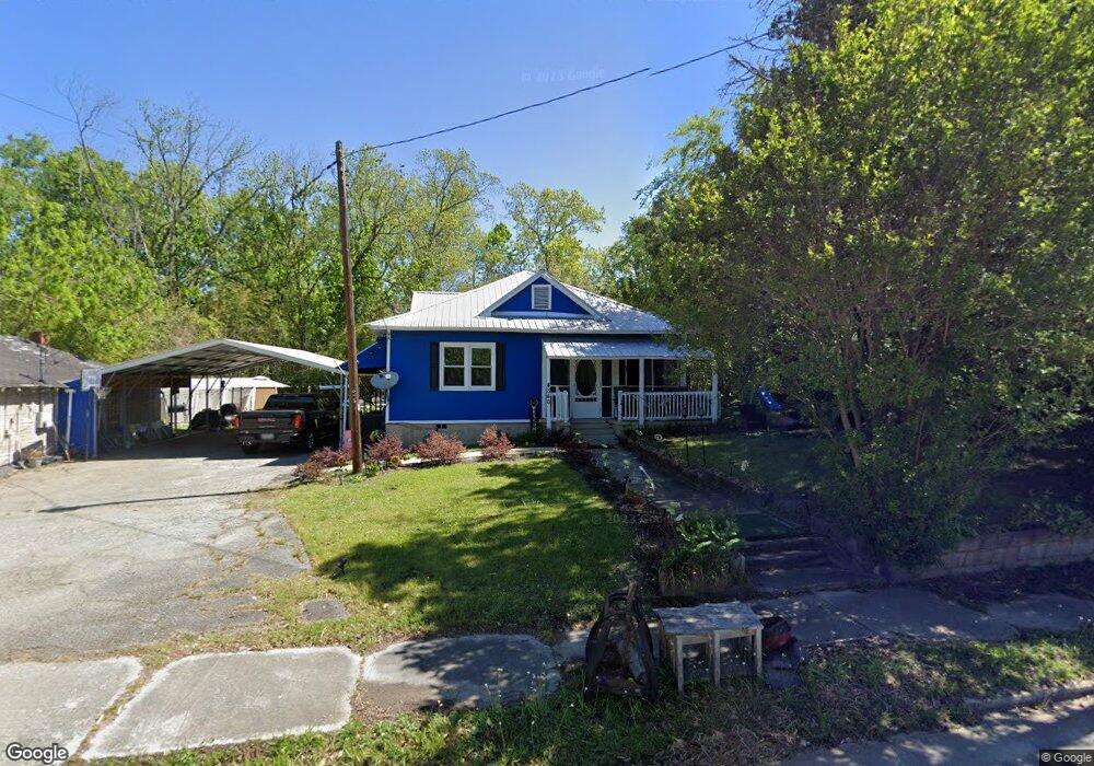
4840 Lamb Ave Union Point, GA 30669
Estimated Value: $118,123 - $147,000
3
Beds
1
Bath
712
Sq Ft
$184/Sq Ft
Est. Value
About This Home
This home is located at 4840 Lamb Ave, Union Point, GA 30669 and is currently estimated at $131,281, approximately $184 per square foot. 4840 Lamb Ave is a home with nearby schools including Greene County High School.
Ownership History
Date
Name
Owned For
Owner Type
Purchase Details
Closed on
Dec 28, 2020
Sold by
Thornton Tony
Bought by
Thornton Tony and Thornton Gail
Current Estimated Value
Purchase Details
Closed on
Aug 31, 2017
Bought by
Thornton Tony
Purchase Details
Closed on
Dec 5, 2013
Sold by
Butler Earl L
Bought by
Martin Mary B
Purchase Details
Closed on
Jan 1, 1958
Bought by
Partridge Mary E B Mrs
Create a Home Valuation Report for This Property
The Home Valuation Report is an in-depth analysis detailing your home's value as well as a comparison with similar homes in the area
Purchase History
| Date | Buyer | Sale Price | Title Company |
|---|---|---|---|
| Thornton Tony | -- | -- | |
| Thornton Tony | $60,000 | -- | |
| Martin Mary B | -- | -- | |
| Partridge Mary E B Mrs | -- | -- |
Source: Public Records
Tax History
| Year | Tax Paid | Tax Assessment Tax Assessment Total Assessment is a certain percentage of the fair market value that is determined by local assessors to be the total taxable value of land and additions on the property. | Land | Improvement |
|---|---|---|---|---|
| 2025 | $673 | $33,400 | $4,560 | $28,840 |
| 2024 | $629 | $31,000 | $4,560 | $26,440 |
| 2023 | $587 | $30,560 | $4,560 | $26,000 |
| 2022 | $349 | $27,480 | $4,560 | $22,920 |
| 2021 | $352 | $25,880 | $4,560 | $21,320 |
| 2020 | $360 | $11,640 | $2,680 | $8,960 |
| 2019 | $368 | $11,640 | $2,680 | $8,960 |
| 2018 | $271 | $11,640 | $2,680 | $8,960 |
| 2017 | $368 | $11,698 | $2,700 | $8,998 |
| 2016 | $372 | $11,698 | $2,700 | $8,998 |
| 2015 | $342 | $11,698 | $2,700 | $8,998 |
| 2014 | $341 | $11,358 | $2,700 | $8,658 |
Source: Public Records
Map
Nearby Homes
- 509 Carlton Ave
- 202 Veazey St
- 93 Carlton Ave
- 405 Crawfordville Rd
- 1241 Old Siloam Rd
- 324 N Rhodes St
- 0 Woodland Ct Unit 10543600
- 215 Hunter St
- 1071 Alexander St
- 000 Washington Hwy
- 0 Washington Hwy Unit 10686255
- 1581 Highway 77 S
- 5401 Union Point Hwy
- 1201 Buffalo Lick Rd
- 0 Buffalo Lick Rd Unit 10551234
- 0 Buffalo Lick Rd Unit 10551325
- 1251 Adams Rd
- 1251 Brick House Rd
- 1251 Brickhouse Rd
- 1681 Sibley School Rd
- 4804 & 503 Lamb Ave
- 00 Lamb Ave
- 4541 Lamb Ave
- 4811 Lamb Ave
- 203 Comfort St
- 4800 Lamb Ave
- 1041 Moody St
- 205 Comfort St
- 206 Comfort St
- 0 Sibley Ave Unit .4 AC 9026524
- 1031 Moody St
- N Lamb Ave
- 205 Binns St
- 208 Comfort St
- 207 Comfort St
- 612 Sibley Ave Unit A & B
- 612 Sibley Ave
- 207 Binns St
- 614 Sibley Ave
- 6.3 acres Georgia 77 Unit 12
Your Personal Tour Guide
Ask me questions while you tour the home.