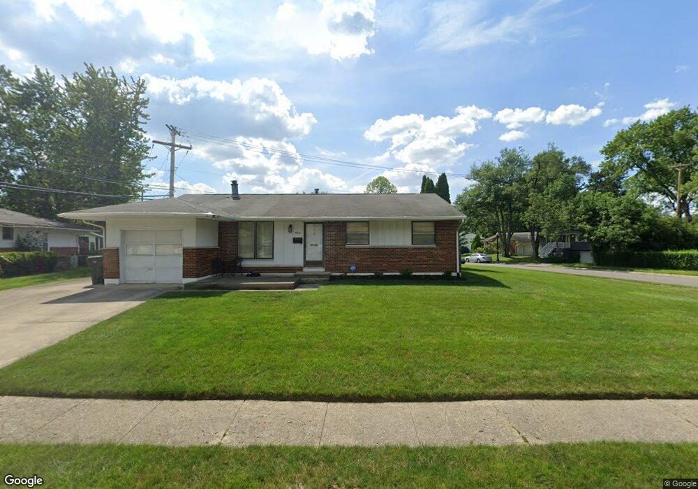
4861 Colonel Perry Dr Columbus, OH 43229
Woodward Park NeighborhoodEstimated Value: $246,708 - $266,000
3
Beds
2
Baths
1,176
Sq Ft
$221/Sq Ft
Est. Value
About This Home
This home is located at 4861 Colonel Perry Dr, Columbus, OH 43229 and is currently estimated at $259,427, approximately $220 per square foot. 4861 Colonel Perry Dr is a home located in Franklin County with nearby schools including Valley Forge Elementary School, Woodward Park Middle School, and Northland High School.
Ownership History
Date
Name
Owned For
Owner Type
Purchase Details
Closed on
Sep 28, 2001
Sold by
Anderson Michael D and Lazaroff Leslie A
Bought by
Tacobucci Clara M
Current Estimated Value
Home Financials for this Owner
Home Financials are based on the most recent Mortgage that was taken out on this home.
Original Mortgage
$91,000
Outstanding Balance
$34,284
Interest Rate
6.99%
Mortgage Type
Purchase Money Mortgage
Estimated Equity
$225,143
Purchase Details
Closed on
Mar 15, 1995
Sold by
Est Sandra Lee Hoover
Bought by
Lazaroff Michael D Anderson and Lazaroff Leslie A
Home Financials for this Owner
Home Financials are based on the most recent Mortgage that was taken out on this home.
Original Mortgage
$73,150
Interest Rate
8.97%
Mortgage Type
New Conventional
Purchase Details
Closed on
Dec 1, 1985
Purchase Details
Closed on
Dec 1, 1977
Create a Home Valuation Report for This Property
The Home Valuation Report is an in-depth analysis detailing your home's value as well as a comparison with similar homes in the area
Home Values in the Area
Average Home Value in this Area
Purchase History
| Date | Buyer | Sale Price | Title Company |
|---|---|---|---|
| Tacobucci Clara M | $103,500 | Chicago Title West | |
| Lazaroff Michael D Anderson | $77,000 | -- | |
| -- | $55,500 | -- | |
| -- | $37,500 | -- |
Source: Public Records
Mortgage History
| Date | Status | Borrower | Loan Amount |
|---|---|---|---|
| Open | Tacobucci Clara M | $91,000 | |
| Previous Owner | Lazaroff Michael D Anderson | $73,150 |
Source: Public Records
Tax History
| Year | Tax Paid | Tax Assessment Tax Assessment Total Assessment is a certain percentage of the fair market value that is determined by local assessors to be the total taxable value of land and additions on the property. | Land | Improvement |
|---|---|---|---|---|
| 2025 | $3,245 | $72,310 | $21,420 | $50,890 |
| 2024 | $3,245 | $72,310 | $21,420 | $50,890 |
| 2023 | $3,204 | $72,310 | $21,420 | $50,890 |
| 2022 | $2,469 | $47,610 | $16,420 | $31,190 |
| 2021 | $2,474 | $47,610 | $16,420 | $31,190 |
| 2020 | $2,477 | $47,610 | $16,420 | $31,190 |
| 2019 | $2,313 | $38,120 | $13,130 | $24,990 |
| 2018 | $2,124 | $38,120 | $13,130 | $24,990 |
| 2017 | $2,311 | $38,120 | $13,130 | $24,990 |
| 2016 | $2,138 | $32,280 | $9,140 | $23,140 |
| 2015 | $1,941 | $32,280 | $9,140 | $23,140 |
| 2014 | $1,946 | $32,280 | $9,140 | $23,140 |
| 2013 | $1,011 | $33,985 | $9,625 | $24,360 |
Source: Public Records
Map
Nearby Homes
- 4818 Colonel Perry Dr
- 4909-4911 Karl Rd
- 4923 Karl Rd Unit 4925
- 1485 Norma Rd
- 5004 Julie Place
- 4852 Snowbird Cir Unit 13B
- 1294 Maize Ct
- 1680 Pin Oak Dr
- 4737 Maize Rd
- 5092 Riverbirch Dr N
- 5352 Hazelwood Rd
- 1638 Arrowood Loop N
- 1167 Reed Circle Dr
- 2064 Waymont Rd
- 1116 Marland Dr N
- 5294 Eisenhower Rd
- 1172 Matthias Dr
- 4141 Karl Rd Unit 310
- 4143 Karl Rd Unit 215
- 4143 Karl Rd Unit 314
- 1491 Urban Dr
- 4851 Colonel Perry Dr
- 1506 Urban Dr
- 1483 Urban Dr
- 4843 Colonel Perry Dr
- 4860 Colonel Perry Dr
- 4868 Colonel Perry Dr
- 1492 Urban Dr
- 4874 Colonel Perry Dr
- 4891 Colonel Perry Dr
- 4856 Bourke Rd
- 4868 Bourke Rd
- 1484 Urban Dr
- 4844 Colonel Perry Dr
- 4835 Colonel Perry Dr
- 4882 Colonel Perry Dr
- 1476 Urban Dr
- 4848 Bourke Rd
- 4901 Colonel Perry Dr
- 4836 Colonel Perry Dr
Your Personal Tour Guide
Ask me questions while you tour the home.