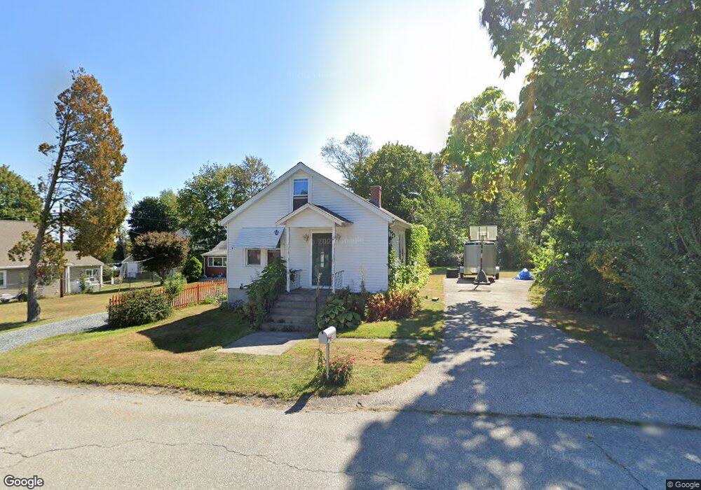
49 Harris Ave Warren, RI 02885
South Warren NeighborhoodEstimated Value: $381,265 - $502,000
2
Beds
1
Bath
968
Sq Ft
$452/Sq Ft
Est. Value
About This Home
This home is located at 49 Harris Ave, Warren, RI 02885 and is currently estimated at $437,066, approximately $451 per square foot. 49 Harris Ave is a home located in Bristol County with nearby schools including Mt. Hope High School, Highlander Charter Middle and High School, and East Bay Career Academy.
Ownership History
Date
Name
Owned For
Owner Type
Purchase Details
Closed on
Feb 24, 2014
Sold by
Tevyaw Lalanya M
Bought by
Wells Mark R
Current Estimated Value
Purchase Details
Closed on
Jan 20, 2009
Sold by
Wells Yvonne
Bought by
Wells Mark R and Tevyan Lalanya M
Home Financials for this Owner
Home Financials are based on the most recent Mortgage that was taken out on this home.
Original Mortgage
$222,323
Interest Rate
5.52%
Mortgage Type
Purchase Money Mortgage
Create a Home Valuation Report for This Property
The Home Valuation Report is an in-depth analysis detailing your home's value as well as a comparison with similar homes in the area
Home Values in the Area
Average Home Value in this Area
Purchase History
We collect this data history from publicly available records. To have your information removed, we recommend requesting removal directly through your county’s website.
| Date | Buyer | Sale Price | Title Company |
|---|---|---|---|
| Wells Mark R | -- | -- | |
| Wells Mark R | $230,000 | -- |
Source: Public Records
Mortgage History
We collect this data history from publicly available records. To have your information removed, we recommend requesting removal directly through your county’s website.
| Date | Status | Borrower | Loan Amount |
|---|---|---|---|
| Previous Owner | Wells Mark R | $211,620 | |
| Previous Owner | Wells Mark R | $222,323 | |
| Previous Owner | Wells Mark R | $195,000 |
Source: Public Records
Tax History
| Year | Tax Paid | Tax Assessment Tax Assessment Total Assessment is a certain percentage of the fair market value that is determined by local assessors to be the total taxable value of land and additions on the property. | Land | Improvement |
|---|---|---|---|---|
| 2025 | $4,457 | $299,300 | $160,400 | $138,900 |
| 2024 | $4,322 | $299,300 | $160,400 | $138,900 |
| 2023 | $4,088 | $299,300 | $160,400 | $138,900 |
| 2022 | $4,357 | $241,900 | $138,400 | $103,500 |
| 2021 | $4,286 | $241,900 | $138,400 | $103,500 |
| 2020 | $4,199 | $241,900 | $138,400 | $103,500 |
| 2019 | $3,877 | $202,900 | $110,400 | $92,500 |
| 2018 | $3,827 | $202,900 | $110,400 | $92,500 |
| 2017 | $3,817 | $202,900 | $110,400 | $92,500 |
| 2016 | $3,653 | $182,900 | $90,400 | $92,500 |
| 2015 | $3,653 | $182,900 | $90,400 | $92,500 |
| 2014 | $3,671 | $182,900 | $90,400 | $92,500 |
Source: Public Records
Map
Nearby Homes
- 0 Overhill Lot 1 Rd Unit 1405163
- 36 Munro Ave
- 1 Saint Anna Ave
- 48 Fatima Dr
- 10 Read Ave
- 5 Saint Theresa Ave
- 770 Metacom Ave
- 596 Metacom Ave
- 5 Casey Dr
- 24 Sandy Ln
- 6 Englewood Ct
- 8 Birchwood Dr
- 5 Village Rd
- 11 Terrace Dr
- 21 Smith St
- 23 Smith St
- 0 Barton Ave
- 511 Child St Unit 205
- 367 Child St
- 5 Pokanoket Trail
Your Personal Tour Guide
Ask me questions while you tour the home.