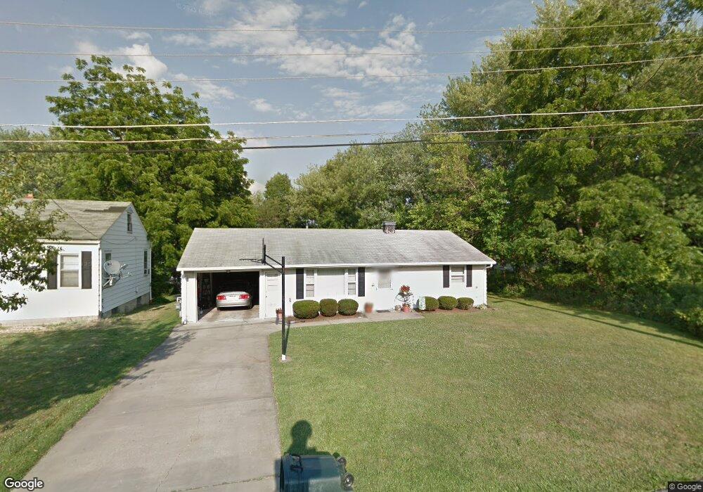
490 11th St Struthers, OH 44471
Estimated Value: $91,000 - $127,000
2
Beds
1
Bath
936
Sq Ft
$115/Sq Ft
Est. Value
About This Home
This home is located at 490 11th St, Struthers, OH 44471 and is currently estimated at $107,726, approximately $115 per square foot. 490 11th St is a home located in Mahoning County with nearby schools including Struthers Elementary School, Struthers Middle School, and Struthers High School.
Ownership History
Date
Name
Owned For
Owner Type
Purchase Details
Closed on
Jun 6, 2023
Sold by
Sevi Teresa and Sevi Teresa Lynn
Bought by
Sevi John Ulisse
Current Estimated Value
Purchase Details
Closed on
Dec 31, 2002
Sold by
Elchuck John F and Elchuck Betty J
Bought by
Sevi Teresa
Purchase Details
Closed on
Nov 1, 1995
Sold by
Klacik Michael J
Bought by
Elchuck John F and Elchuck Betty J
Home Financials for this Owner
Home Financials are based on the most recent Mortgage that was taken out on this home.
Original Mortgage
$27,700
Interest Rate
7.61%
Mortgage Type
New Conventional
Purchase Details
Closed on
Sep 25, 1992
Bought by
Dollar Sav & Tr Co Tr
Create a Home Valuation Report for This Property
The Home Valuation Report is an in-depth analysis detailing your home's value as well as a comparison with similar homes in the area
Home Values in the Area
Average Home Value in this Area
Purchase History
| Date | Buyer | Sale Price | Title Company |
|---|---|---|---|
| Sevi John Ulisse | -- | -- | |
| Sevi Teresa | -- | -- | |
| Elchuck John F | $42,700 | -- | |
| Dollar Sav & Tr Co Tr | -- | -- |
Source: Public Records
Mortgage History
| Date | Status | Borrower | Loan Amount |
|---|---|---|---|
| Previous Owner | Elchuck John F | $27,700 |
Source: Public Records
Tax History
| Year | Tax Paid | Tax Assessment Tax Assessment Total Assessment is a certain percentage of the fair market value that is determined by local assessors to be the total taxable value of land and additions on the property. | Land | Improvement |
|---|---|---|---|---|
| 2025 | $666 | $26,100 | $3,990 | $22,110 |
| 2024 | $680 | $26,100 | $3,990 | $22,110 |
| 2023 | $695 | $26,100 | $3,990 | $22,110 |
| 2022 | $445 | $16,940 | $4,070 | $12,870 |
| 2021 | $441 | $16,940 | $4,070 | $12,870 |
| 2020 | $443 | $16,940 | $4,070 | $12,870 |
| 2019 | $359 | $14,730 | $3,540 | $11,190 |
| 2018 | $856 | $14,730 | $3,540 | $11,190 |
| 2017 | $874 | $14,730 | $3,540 | $11,190 |
| 2016 | $896 | $15,840 | $4,430 | $11,410 |
| 2015 | $876 | $15,840 | $4,430 | $11,410 |
| 2014 | $879 | $15,840 | $4,430 | $11,410 |
| 2013 | $819 | $15,840 | $4,430 | $11,410 |
Source: Public Records
Map
Nearby Homes
- 541 Lincoln St
- 610 Elm St
- 414 10th St
- 0 Crescent Dr Unit 5124984
- 417 9th St
- 612 Maplewood Ave
- 447 8th St
- 464 Elm St
- 457 Sexton St
- 2003 E Midlothian Blvd
- 1970 Weston Ave
- 3524 Champlain Ave
- 1962 Bancroft Ave
- 2025 Pointview Ave
- 1925 Weston Ave
- 3516 Champlain Ave
- 2016 Pointview Ave
- 0 Weston Ave
- 3629 Irma St
- 611 W Wilson St
- 486 11th St
- 495 10th St
- 588 Lincoln Ave Unit 590
- 491 10th St
- 584 Lincoln Ave Unit 586
- 513 10th St
- 487 11th St
- 489 11th St
- 580 Lincoln Ave Unit 582
- 485 11th St
- 20 Anna Cir Unit 20
- 574 Lincoln Ave
- 483 11th St
- 570 Lincoln Ave Unit 572
- 481 11th St
- 521 10th St
- 595 Lincoln Ave
- 511 Lincoln Ave
- 601 Lincoln Ave
- 571 Lincoln Ave
Your Personal Tour Guide
Ask me questions while you tour the home.