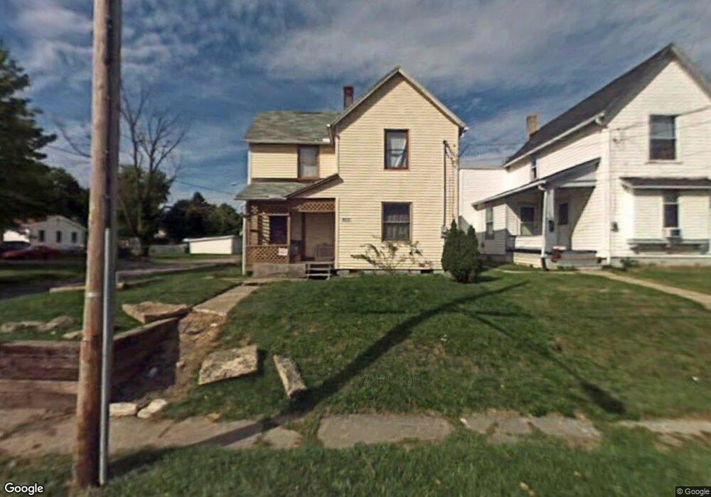
493 Johns Ave Mansfield, OH 44903
Estimated Value: $51,000 - $78,000
3
Beds
1
Bath
1,364
Sq Ft
$49/Sq Ft
Est. Value
About This Home
This home is located at 493 Johns Ave, Mansfield, OH 44903 and is currently estimated at $66,496, approximately $48 per square foot. 493 Johns Ave is a home located in Richland County with nearby schools including Goal Digital Academy, St. Peter's Elementary/Montessori School, and St. Peter's Junior High / High School.
Ownership History
Date
Name
Owned For
Owner Type
Purchase Details
Closed on
Sep 28, 2016
Sold by
Scott Randy M
Bought by
Value Housing Llc
Current Estimated Value
Purchase Details
Closed on
Apr 15, 2005
Sold by
Kauffman Harold Dean and Kauffman Ellen G
Bought by
Scott Randy M and Seiter Teresa G
Home Financials for this Owner
Home Financials are based on the most recent Mortgage that was taken out on this home.
Original Mortgage
$11,950
Interest Rate
5.88%
Mortgage Type
Seller Take Back
Purchase Details
Closed on
May 28, 1997
Sold by
Eckert Harold E
Bought by
Canankamp Lola J and Canankamp James M
Purchase Details
Closed on
Feb 26, 1997
Sold by
Eckert Harold E
Bought by
Canankamp James M and Canankamp Lola J
Create a Home Valuation Report for This Property
The Home Valuation Report is an in-depth analysis detailing your home's value as well as a comparison with similar homes in the area
Home Values in the Area
Average Home Value in this Area
Purchase History
| Date | Buyer | Sale Price | Title Company |
|---|---|---|---|
| Value Housing Llc | $3,000 | Chicago Title Agency Of Nort | |
| Scott Randy M | $12,000 | -- | |
| Canankamp Lola J | $7,000 | -- | |
| Canankamp James M | $7,000 | -- |
Source: Public Records
Mortgage History
| Date | Status | Borrower | Loan Amount |
|---|---|---|---|
| Previous Owner | Scott Randy M | $11,950 |
Source: Public Records
Tax History
| Year | Tax Paid | Tax Assessment Tax Assessment Total Assessment is a certain percentage of the fair market value that is determined by local assessors to be the total taxable value of land and additions on the property. | Land | Improvement |
|---|---|---|---|---|
| 2025 | $60 | $1,260 | $790 | $470 |
| 2024 | $60 | $1,260 | $790 | $470 |
| 2023 | $60 | $1,260 | $790 | $470 |
| 2022 | $61 | $1,070 | $720 | $350 |
| 2021 | $62 | $1,070 | $720 | $350 |
| 2020 | $63 | $1,070 | $720 | $350 |
| 2019 | $70 | $1,070 | $720 | $350 |
| 2018 | $69 | $1,070 | $720 | $350 |
| 2017 | $865 | $13,810 | $1,560 | $12,250 |
| 2016 | $765 | $1,050 | $740 | $310 |
| 2015 | $731 | $11,850 | $2,470 | $9,380 |
| 2014 | $721 | $11,850 | $2,470 | $9,380 |
| 2012 | $553 | $11,850 | $2,600 | $9,250 |
Source: Public Records
Map
Nearby Homes
- 524 Lida St
- 0 Voegele Ave Unit Lot 6048, 6049, 6
- 701 Springmill St
- 0 Grant Rd Unit 5190994
- 580 N Mulberry St
- 118 Raymond Ave
- 516 Burns St
- 0 Highway 30
- 368 W 6th St
- 447 Spayer Ln
- 572 France St
- 344 W 5th St
- 224 Atcheson Ave
- 219 W 5th St
- 0 State Route 314 Unit 9069650
- 688 Mcpherson St
- 245 W 4th St
- 0 Lemley Ave Unit 9070540
- 10 Gray Ct
- 458 W West Dickson Ave
Your Personal Tour Guide
Ask me questions while you tour the home.