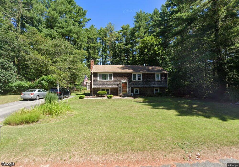
5 Jason Dr Carver, MA 02330
Estimated Value: $428,000 - $485,000
3
Beds
1
Bath
1,008
Sq Ft
$460/Sq Ft
Est. Value
About This Home
This home is located at 5 Jason Dr, Carver, MA 02330 and is currently estimated at $463,810, approximately $460 per square foot. 5 Jason Dr is a home located in Plymouth County with nearby schools including Carver Elementary School and Carver Middle/High School.
Ownership History
Date
Name
Owned For
Owner Type
Purchase Details
Closed on
Apr 2, 2021
Sold by
Buck Paul G and Buck Alexandra D
Bought by
Blackburn-Buck Andrew and Buck Kaitlyn V
Current Estimated Value
Home Financials for this Owner
Home Financials are based on the most recent Mortgage that was taken out on this home.
Original Mortgage
$299,250
Outstanding Balance
$269,310
Interest Rate
2.8%
Mortgage Type
Purchase Money Mortgage
Estimated Equity
$194,500
Purchase Details
Closed on
Mar 1, 1983
Bought by
Buck Paul G and Buck Alexandra D
Create a Home Valuation Report for This Property
The Home Valuation Report is an in-depth analysis detailing your home's value as well as a comparison with similar homes in the area
Home Values in the Area
Average Home Value in this Area
Purchase History
| Date | Buyer | Sale Price | Title Company |
|---|---|---|---|
| Blackburn-Buck Andrew | $315,000 | None Available | |
| Buck Paul G | -- | -- |
Source: Public Records
Mortgage History
| Date | Status | Borrower | Loan Amount |
|---|---|---|---|
| Open | Blackburn-Buck Andrew | $299,250 | |
| Previous Owner | Buck Paul G | $170,340 | |
| Previous Owner | Buck Paul G | $190,000 | |
| Previous Owner | Buck Paul G | $80,000 |
Source: Public Records
Tax History
| Year | Tax Paid | Tax Assessment Tax Assessment Total Assessment is a certain percentage of the fair market value that is determined by local assessors to be the total taxable value of land and additions on the property. | Land | Improvement |
|---|---|---|---|---|
| 2025 | $5,832 | $420,500 | $147,700 | $272,800 |
| 2024 | $5,862 | $413,700 | $152,000 | $261,700 |
| 2023 | $5,674 | $388,900 | $152,000 | $236,900 |
| 2022 | $5,342 | $334,300 | $130,000 | $204,300 |
| 2021 | $5,262 | $310,600 | $116,100 | $194,500 |
| 2020 | $5,004 | $291,100 | $108,500 | $182,600 |
| 2019 | $4,861 | $285,100 | $105,300 | $179,800 |
| 2018 | $4,884 | $264,100 | $105,300 | $158,800 |
| 2017 | $4,543 | $256,800 | $101,300 | $155,500 |
| 2016 | $4,051 | $237,900 | $96,500 | $141,400 |
| 2015 | $3,975 | $233,700 | $96,500 | $137,200 |
| 2014 | $4,008 | $235,600 | $122,000 | $113,600 |
Source: Public Records
Map
Nearby Homes
- 16 S Main St
- 116 Meadow St
- 5 Ohana Way
- 715 County Rd
- 3 Balmy Ln Unit 3
- 5 Marks Way
- 29 Presidents Way
- 36 Cheryl Ln
- 27 Ridge Dr Unit 27
- 4 Justines Way
- 1 Crystal Lake Dr
- 500 Wareham St
- 235 Main St
- 28 Wareham St
- 2232 Cranberry Hwy Unit B
- 2230 Cranberry Hwy Unit A
- 2230 Cranberry Hwy
- 21 Myles Standish Dr
- 37 Rocky Gutter St
- 480 Wareham St
Your Personal Tour Guide
Ask me questions while you tour the home.