N
Seller's Agent in 2025
Nancy Leonard
William Raveis Real Estate
(203) 494-3660
1 in this area
12 Total Sales
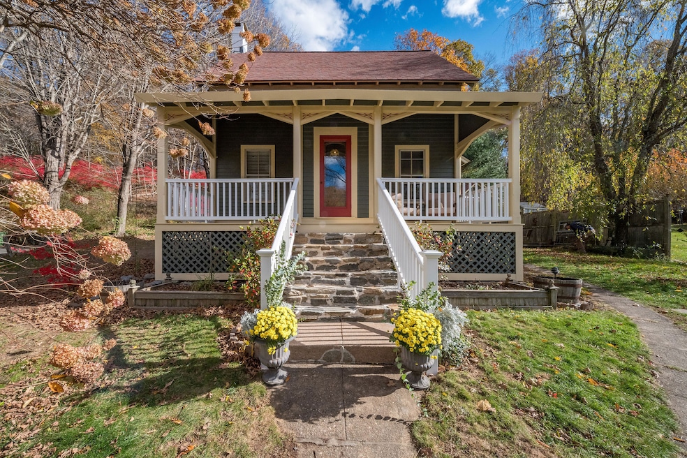
With front porch charm, blooming perennial gardens, and that unmistakable storybook feeling, this home instantly captures your heart. Lovingly cared for over the years, it offers the perfect balance of comfort and character. The updated kitchen opens to a sunlit dining and family area, creating a welcoming space for gatherings. A cozy reading nook and an inviting office and half bath makes the first floor both functional and full of personality. Upstairs, two tranquil bedrooms and a full bath offer a peaceful retreat, all enhanced by hardwood floors. Thoughtful updates include fresh exterior paint, a repointed and repainted chimney, new front porch railings, and refreshed interior walls. A walk-up attic adds generous storage, and all mechanical systems have been diligently maintained. Best of all, you're just a short walk from the town center and the picturesque Town Landing on the Connecticut River - where neighbors gather, boats launch, and sunsets are best enjoyed from the gazebo.
Last Agent to Sell the Property
William Raveis Real Estate Brokerage Phone: (203) 494-3660 License #RES.0397846 Listed on: 11/12/2025

| Date | Type | Sale Price | Title Company |
|---|---|---|---|
| Deed | $133,500 | -- |
| Date | Status | Loan Amount | Loan Type |
|---|---|---|---|
| Open | $57,000 | No Value Available | |
| Closed | $130,000 | No Value Available | |
| Closed | $101,000 | No Value Available | |
| Closed | $106,800 | Purchase Money Mortgage |
| Date | Event | Price | List to Sale | Price per Sq Ft |
|---|---|---|---|---|
| 12/29/2025 12/29/25 | Sold | $366,000 | +14.4% | $339 / Sq Ft |
| 11/20/2025 11/20/25 | Pending | -- | -- | -- |
| 11/18/2025 11/18/25 | For Sale | $319,900 | -12.6% | $296 / Sq Ft |
| 11/18/2025 11/18/25 | Off Market | $366,000 | -- | -- |
| 11/16/2025 11/16/25 | For Sale | $319,900 | -- | $296 / Sq Ft |
| Year | Tax Paid | Tax Assessment Tax Assessment Total Assessment is a certain percentage of the fair market value that is determined by local assessors to be the total taxable value of land and additions on the property. | Land | Improvement |
|---|---|---|---|---|
| 2025 | $5,082 | $158,900 | $43,470 | $115,430 |
| 2024 | $4,986 | $158,900 | $43,470 | $115,430 |
| 2023 | $4,748 | $158,900 | $43,470 | $115,430 |
| 2022 | $4,605 | $158,900 | $43,470 | $115,430 |
| 2021 | $4,700 | $158,900 | $43,470 | $115,430 |
| 2020 | $4,469 | $149,030 | $44,240 | $104,790 |
| 2019 | $4,384 | $149,030 | $44,240 | $104,790 |
| 2018 | $4,384 | $149,030 | $44,240 | $104,790 |
| 2017 | $4,310 | $149,030 | $44,240 | $104,790 |
| 2016 | $4,103 | $149,030 | $44,240 | $104,790 |
| 2015 | $3,948 | $150,220 | $49,140 | $101,080 |
| 2014 | $3,888 | $150,220 | $49,140 | $101,080 |
N
Seller's Agent in 2025
Nancy Leonard
William Raveis Real Estate
(203) 494-3660
1 in this area
12 Total Sales
Buyer's Agent in 2025
Maureen Evans
William Raveis Real Estate
(860) 391-3747
3 in this area
12 Total Sales
Source: SmartMLS
MLS Number: 24139126
APN: DEEP-000055-000000-000025A
Disclaimer: Certain information contained herein is derived from information provided by parties other than Homes.com. All information provided is deemed reliable, but is not guaranteed to be accurate and should be independently verified.
![]() IDX information is provided exclusively for personal, non-commercial use, and may not be used for any purpose other than to identify prospective properties consumers may be interested in purchasing. Information is deemed reliable but not guaranteed.
IDX information is provided exclusively for personal, non-commercial use, and may not be used for any purpose other than to identify prospective properties consumers may be interested in purchasing. Information is deemed reliable but not guaranteed.
Ask me questions while you tour the home.