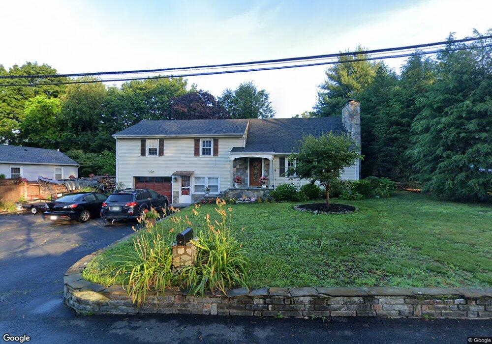
5 Moore St Darien, CT 06820
Estimated Value: $815,000 - $2,320,000
3
Beds
3
Baths
2,090
Sq Ft
$660/Sq Ft
Est. Value
About This Home
This home is located at 5 Moore St, Darien, CT 06820 and is currently estimated at $1,378,580, approximately $659 per square foot. 5 Moore St is a home located in Fairfield County with nearby schools including Holmes Elementary School, Middlesex Middle School, and Darien High School.
Ownership History
Date
Name
Owned For
Owner Type
Purchase Details
Closed on
Dec 30, 2020
Sold by
Berisha Tom and Berisha Anton
Bought by
Berisha Anton and Berisha Violeta
Current Estimated Value
Purchase Details
Closed on
Oct 18, 1999
Sold by
Coutermash Madeline and Coutermash Edward A
Bought by
Berisha Tom and Berisha Anton
Home Financials for this Owner
Home Financials are based on the most recent Mortgage that was taken out on this home.
Original Mortgage
$210,000
Interest Rate
7.8%
Create a Home Valuation Report for This Property
The Home Valuation Report is an in-depth analysis detailing your home's value as well as a comparison with similar homes in the area
Home Values in the Area
Average Home Value in this Area
Purchase History
| Date | Buyer | Sale Price | Title Company |
|---|---|---|---|
| Berisha Anton | -- | None Available | |
| Berisha Tom | $360,000 | -- |
Source: Public Records
Mortgage History
| Date | Status | Borrower | Loan Amount |
|---|---|---|---|
| Previous Owner | Berisha Tom | $210,000 |
Source: Public Records
Tax History
| Year | Tax Paid | Tax Assessment Tax Assessment Total Assessment is a certain percentage of the fair market value that is determined by local assessors to be the total taxable value of land and additions on the property. | Land | Improvement |
|---|---|---|---|---|
| 2025 | $8,440 | $545,230 | $336,280 | $208,950 |
| 2024 | $8,009 | $545,230 | $336,280 | $208,950 |
| 2023 | $8,421 | $478,170 | $320,320 | $157,850 |
| 2022 | $8,239 | $478,170 | $320,320 | $157,850 |
| 2021 | $8,052 | $478,170 | $320,320 | $157,850 |
| 2020 | $7,823 | $478,170 | $320,320 | $157,850 |
| 2019 | $13,633 | $478,170 | $320,320 | $157,850 |
| 2018 | $6,283 | $390,740 | $264,460 | $126,280 |
| 2017 | $6,314 | $390,740 | $264,460 | $126,280 |
| 2016 | $6,162 | $390,740 | $264,460 | $126,280 |
| 2015 | $5,998 | $390,740 | $264,460 | $126,280 |
| 2014 | $5,865 | $390,740 | $264,460 | $126,280 |
Source: Public Records
Map
Nearby Homes
- 15 Charles St
- 11 Patton Dr
- 167 Hollow Tree Ridge Rd
- 166 Hollow Tree Ridge Rd
- 22 Radio Place Unit 10
- 88 Maple Tree Ave Unit G
- 12 Walmsley Rd
- 25 Devon Rd
- 86 Middlesex Rd
- 29 Walmsley Rd
- 3 Abbey Rd
- 66 Stanton Rd
- 24 King St
- 25 Hillside Ave
- 3 Hickory Ln
- 15 Tremont Ave
- 5 Middlesex Rd
- 32 Relihan Rd
- 151 Courtland Ave Unit 6
- 135 Courtland Ave Unit 13
Your Personal Tour Guide
Ask me questions while you tour the home.