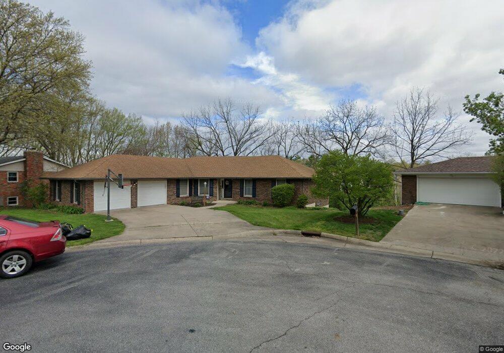
5 Mumford Dr Columbia, MO 65203
Estimated Value: $354,000 - $382,000
4
Beds
3
Baths
2,850
Sq Ft
$130/Sq Ft
Est. Value
About This Home
This home is located at 5 Mumford Dr, Columbia, MO 65203 and is currently estimated at $370,278, approximately $129 per square foot. 5 Mumford Dr is a home located in Boone County with nearby schools including Fairview Elementary School, Smithton Middle School, and David H. Hickman High School.
Ownership History
Date
Name
Owned For
Owner Type
Purchase Details
Closed on
May 26, 2010
Sold by
Hays Daniel F and Hays Carol D
Bought by
Kimmons Janet E
Current Estimated Value
Home Financials for this Owner
Home Financials are based on the most recent Mortgage that was taken out on this home.
Original Mortgage
$97,200
Outstanding Balance
$65,239
Interest Rate
5%
Mortgage Type
New Conventional
Estimated Equity
$305,039
Purchase Details
Closed on
Jun 24, 2009
Sold by
Klocko Timothy E and Klocko Beverly J
Bought by
Hays Daniel F and Hays Carole D
Home Financials for this Owner
Home Financials are based on the most recent Mortgage that was taken out on this home.
Original Mortgage
$162,000
Interest Rate
4.83%
Mortgage Type
Future Advance Clause Open End Mortgage
Create a Home Valuation Report for This Property
The Home Valuation Report is an in-depth analysis detailing your home's value as well as a comparison with similar homes in the area
Purchase History
| Date | Buyer | Sale Price | Title Company |
|---|---|---|---|
| Kimmons Janet E | -- | None Available | |
| Hays Daniel F | -- | None Available |
Source: Public Records
Mortgage History
| Date | Status | Borrower | Loan Amount |
|---|---|---|---|
| Open | Kimmons Janet E | $97,200 | |
| Previous Owner | Hays Daniel F | $162,000 |
Source: Public Records
Tax History
| Year | Tax Paid | Tax Assessment Tax Assessment Total Assessment is a certain percentage of the fair market value that is determined by local assessors to be the total taxable value of land and additions on the property. | Land | Improvement |
|---|---|---|---|---|
| 2025 | $2,675 | $40,850 | $4,370 | $36,480 |
| 2024 | $2,407 | $35,682 | $4,370 | $31,312 |
| 2023 | $2,387 | $35,682 | $4,370 | $31,312 |
| 2022 | $2,208 | $33,041 | $4,370 | $28,671 |
| 2021 | $2,212 | $33,041 | $4,370 | $28,671 |
| 2020 | $2,180 | $30,595 | $4,370 | $26,225 |
| 2019 | $2,180 | $30,595 | $4,370 | $26,225 |
| 2018 | $2,033 | $0 | $0 | $0 |
| 2017 | $2,008 | $28,329 | $4,370 | $23,959 |
| 2016 | $2,005 | $28,329 | $4,370 | $23,959 |
| 2015 | $1,841 | $28,329 | $4,370 | $23,959 |
| 2014 | -- | $28,329 | $4,370 | $23,959 |
Source: Public Records
Map
Nearby Homes
- 108 Defoe Ct
- 4004 Day Flower Ct
- 205 Cornerstone Ct
- 3801 W Rollins Rd
- 120 Reedsport Ridge
- 210 Blue Sky Ct
- 4002 W Worley St Unit 4 St
- 4100 W Worley St Unit 106
- 4002 W Worley St Unit 3
- 4411 Maxwell Ln
- 4100 Hartfield Dr
- 706 Park de Ville Place
- 2201 Park de Ville Place
- 2308 Park de Ville Place
- 3920 Tolarian Dr
- 2801 W Broadway Unit P-1
- 2801 W Broadway
- 2801 W Broadway Unit 4
- 2705 Park de Ville Place
- 2723 Braemore Rd
Your Personal Tour Guide
Ask me questions while you tour the home.