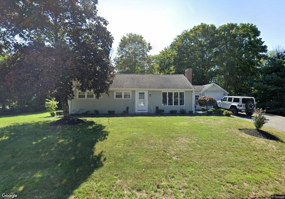
5 Redbird Rd Wrentham, MA 02093
Estimated Value: $515,000 - $697,000
3
Beds
1
Bath
924
Sq Ft
$615/Sq Ft
Est. Value
About This Home
This home is located at 5 Redbird Rd, Wrentham, MA 02093 and is currently estimated at $568,033, approximately $614 per square foot. 5 Redbird Rd is a home located in Norfolk County with nearby schools including Delaney Elementary School, Charles E Roderick, and Discovery Daycare Center.
Ownership History
Date
Name
Owned For
Owner Type
Purchase Details
Closed on
Aug 20, 2003
Sold by
Marland Stephen L and Marland Miriam B
Bought by
Kablin Jimmy and Barcomb Mary
Current Estimated Value
Home Financials for this Owner
Home Financials are based on the most recent Mortgage that was taken out on this home.
Original Mortgage
$273,600
Outstanding Balance
$119,605
Interest Rate
5.52%
Mortgage Type
Purchase Money Mortgage
Estimated Equity
$448,428
Create a Home Valuation Report for This Property
The Home Valuation Report is an in-depth analysis detailing your home's value as well as a comparison with similar homes in the area
Purchase History
| Date | Buyer | Sale Price | Title Company |
|---|---|---|---|
| Kablin Jimmy | $288,000 | -- |
Source: Public Records
Mortgage History
| Date | Status | Borrower | Loan Amount |
|---|---|---|---|
| Open | Kablin Jimmy | $273,600 | |
| Previous Owner | Kablin Jimmy | $91,000 |
Source: Public Records
Tax History
| Year | Tax Paid | Tax Assessment Tax Assessment Total Assessment is a certain percentage of the fair market value that is determined by local assessors to be the total taxable value of land and additions on the property. | Land | Improvement |
|---|---|---|---|---|
| 2025 | $4,969 | $428,700 | $234,300 | $194,400 |
| 2024 | $4,552 | $379,300 | $234,300 | $145,000 |
| 2023 | $4,262 | $337,700 | $213,000 | $124,700 |
| 2022 | $4,213 | $308,200 | $191,800 | $116,400 |
| 2021 | $3,969 | $282,100 | $171,300 | $110,800 |
| 2020 | $3,768 | $264,400 | $156,400 | $108,000 |
| 2019 | $3,707 | $262,500 | $156,400 | $106,100 |
| 2018 | $3,878 | $272,300 | $156,400 | $115,900 |
| 2017 | $3,662 | $257,000 | $153,400 | $103,600 |
| 2016 | $3,579 | $250,600 | $149,000 | $101,600 |
| 2015 | $3,445 | $230,000 | $143,200 | $86,800 |
| 2014 | $3,387 | $221,200 | $137,700 | $83,500 |
Source: Public Records
Map
Nearby Homes
- 15 Tilting Rock Rd
- 10 Nature View Dr
- 15 Nature View Dr
- 3 Earle Stewart Ln
- 2 Earle Stewart Ln
- 10 Earle Stewart Ln Unit Lot 5
- 12 Earle Stewart Ln
- 135 Creek St Unit 2
- 151 Dedham St
- 282 Thurston St
- 500 Franklin St
- 483 Thurston St
- 55 Walnut Rd
- 576 Dedham St
- 165 Wampum St
- 10 Sycamore Rd
- 1 Weber Farm Rd Unit 1
- 4 Weber Farm Rd Unit 4
- 11 Weber Farm Rd Unit 11
- 6 Weber Farm Rd Unit 6
- 6 Redbird Rd
- 197 Taunton St
- 220 Taunton St
- 13 Redbird Rd
- 209 Taunton St
- 14 Redbird Rd
- 183 Taunton St
- 180 Taunton St
- 215 Taunton St
- 177 Taunton St
- 224 Taunton St Unit 224
- 224 Taunton St Unit 1
- 224 Taunton St
- 224 Taunton St
- 24 Redbird Rd
- 226 Taunton St
- 221 Taunton St
- 227 Taunton St
- 169 Taunton St
- 33 Redbird Rd
Your Personal Tour Guide
Ask me questions while you tour the home.