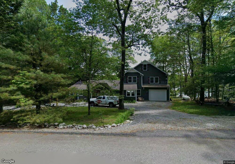
5 W Shore Dr Newton, NJ 07860
Estimated Value: $360,000 - $557,000
Studio
--
Bath
2,196
Sq Ft
$214/Sq Ft
Est. Value
About This Home
This home is located at 5 W Shore Dr, Newton, NJ 07860 and is currently estimated at $470,349, approximately $214 per square foot. 5 W Shore Dr is a home located in Sussex County with nearby schools including Marian E. McKeown School and Kittatinny Regional High School.
Ownership History
Date
Name
Owned For
Owner Type
Purchase Details
Closed on
Nov 20, 2003
Sold by
Valeich Edward M
Bought by
Kopp James R
Current Estimated Value
Purchase Details
Closed on
Oct 29, 2002
Sold by
The Township Of Hampton
Bought by
Peters Kevin R and Peters Kelly J
Purchase Details
Closed on
Jul 18, 2000
Sold by
Danzi Christine A
Bought by
Peters Kevin R and Peters Kelly J
Home Financials for this Owner
Home Financials are based on the most recent Mortgage that was taken out on this home.
Original Mortgage
$88,000
Interest Rate
8.18%
Create a Home Valuation Report for This Property
The Home Valuation Report is an in-depth analysis detailing your home's value as well as a comparison with similar homes in the area
Home Values in the Area
Average Home Value in this Area
Purchase History
| Date | Buyer | Sale Price | Title Company |
|---|---|---|---|
| Kopp James R | $129,000 | -- | |
| Peters Kevin R | -- | -- | |
| Peters Kevin R | $110,000 | -- |
Source: Public Records
Mortgage History
| Date | Status | Borrower | Loan Amount |
|---|---|---|---|
| Previous Owner | Peters Kevin R | $88,000 |
Source: Public Records
Tax History
| Year | Tax Paid | Tax Assessment Tax Assessment Total Assessment is a certain percentage of the fair market value that is determined by local assessors to be the total taxable value of land and additions on the property. | Land | Improvement |
|---|---|---|---|---|
| 2025 | $11,116 | $333,000 | $139,200 | $193,800 |
| 2024 | $10,526 | $333,000 | $139,200 | $193,800 |
Source: Public Records
Map
Nearby Homes
- 000 Pepperidge Dr
- 14 E Shore Dr
- 40 E Shore Dr
- 901 Chestnut Path
- 15 Copeley Rd
- 27 Plaza Dr
- 41 Kent Rd
- 68 W Shore Dr
- 900 Primrose Path
- 31 Kent Rd
- 0 Mount Benevolence Rd
- 90 Kemah Mecca Lake Rd
- 17 17 West Owassa Tnpk
- 239 E Shore Lake Owassa Rd
- 00 Plymouth Lake Dr
- 911 Upper Dr
- 951 Owassa Rd
- 4 Grove St
- 51 E Shore Lake Owassa Rd
- 15 Ike Williams Rd
- 7 W Shore Dr
- 1 W Shore Dr
- 1056 W Shore Dr Rt 521
- 904 Crandon Lake Dr W
- 11 W Shore Dr
- 13 W Shore Dr
- 1 Maple Path
- 904 Poplar Terrace
- 904 Pepperidge Dr
- 902 Tupelo Path
- 903 Crandon Lake Dr W
- 15 W Shore Dr
- 903 Pepperidge Dr
- 2 Palmetto Trail
- 901 Aspen Ct
- 908 Tulip Trail
- 903 Maple Path
- 0 Pepperidge Dr
- 905 Pepperidge Dr
- 901 Tulip Trail
Your Personal Tour Guide
Ask me questions while you tour the home.