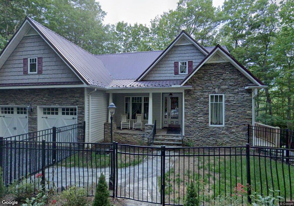
50 Robin Cir Newland, NC 28657
Estimated Value: $503,000 - $641,000
4
Beds
5
Baths
2,149
Sq Ft
$267/Sq Ft
Est. Value
About This Home
This home is located at 50 Robin Cir, Newland, NC 28657 and is currently estimated at $573,467, approximately $266 per square foot. 50 Robin Cir is a home with nearby schools including Crossnore Elementary School, Avery Middle School, and Avery County High School.
Ownership History
Date
Name
Owned For
Owner Type
Purchase Details
Closed on
Nov 4, 2022
Sold by
Ferguson Peggy M and Ferguson Joseph S
Bought by
Ferguson Peggy M
Current Estimated Value
Home Financials for this Owner
Home Financials are based on the most recent Mortgage that was taken out on this home.
Original Mortgage
$370,000
Outstanding Balance
$356,952
Interest Rate
6.92%
Mortgage Type
New Conventional
Estimated Equity
$216,515
Purchase Details
Closed on
Jun 12, 2017
Sold by
Ferguson Peggy Moorefield
Bought by
Ferguson Peggy M and Moorefield Joseph S
Home Financials for this Owner
Home Financials are based on the most recent Mortgage that was taken out on this home.
Original Mortgage
$300,000
Interest Rate
4.5%
Mortgage Type
Adjustable Rate Mortgage/ARM
Purchase Details
Closed on
Apr 10, 2017
Sold by
Ferguson Stanley Grady
Bought by
Ferguson Peggy Moore Field
Create a Home Valuation Report for This Property
The Home Valuation Report is an in-depth analysis detailing your home's value as well as a comparison with similar homes in the area
Home Values in the Area
Average Home Value in this Area
Purchase History
| Date | Buyer | Sale Price | Title Company |
|---|---|---|---|
| Ferguson Peggy M | -- | -- | |
| Ferguson Peggy M | -- | None Available | |
| Ferguson Peggy Moore Field | -- | None Available |
Source: Public Records
Mortgage History
| Date | Status | Borrower | Loan Amount |
|---|---|---|---|
| Open | Ferguson Peggy M | $370,000 | |
| Previous Owner | Ferguson Peggy M | $300,000 |
Source: Public Records
Tax History
| Year | Tax Paid | Tax Assessment Tax Assessment Total Assessment is a certain percentage of the fair market value that is determined by local assessors to be the total taxable value of land and additions on the property. | Land | Improvement |
|---|---|---|---|---|
| 2025 | $1,619 | $404,700 | $45,000 | $359,700 |
| 2024 | $1,619 | $404,700 | $45,000 | $359,700 |
| 2023 | $1,619 | $404,700 | $45,000 | $359,700 |
| 2022 | $1,619 | $404,700 | $45,000 | $359,700 |
| 2021 | $1,863 | $338,700 | $33,800 | $304,900 |
| 2020 | $1,863 | $338,700 | $33,800 | $304,900 |
| 2019 | $1,863 | $338,700 | $33,800 | $304,900 |
| 2018 | $1,863 | $338,700 | $33,800 | $304,900 |
| 2017 | $1,934 | $351,700 | $0 | $0 |
| 2016 | $1,573 | $351,700 | $0 | $0 |
| 2015 | $1,573 | $351,700 | $33,800 | $317,900 |
| 2012 | -- | $416,800 | $54,000 | $362,800 |
Source: Public Records
Map
Nearby Homes
- 72 Robin Cir
- 365 Trout Brook Loop
- 14 Briar Rd
- 335 Snowshoe Loop
- 6 Ridgewood Ln
- 228 Snowshoe Loop
- 12 Yarrow Cir
- 153 Snowshoe Loop
- 134 Goldfinch Rd
- 439 Locust Rd
- 36 Larkspur Rd
- 192 Pine Ridge Loop
- 7 Valley Ln
- 80 Pine Valley Rd
- 17 Elderberry Loop
- 25 Poke Rd
- 4 Trillium Rd
- 83 Pine Ridge Loop
- 478 Laurel Hills Rd
- 54 Whispering Pine Loop
- 347 Trout Brook Loop
- 54 Robin Cir
- 42 Robin Cir
- 34 Robin Cir
- 278 Trout Brook Loop
- 80 Robin Cir
- 620 Old Mill Timber Creek Rd
- 334 Trout Brook Loop
- 20 Robin Cir
- 90 Robin Cir
- 10 Robin Cir
- 218 Trout Brook Loop
- 365 Trout Brook Loop Unit 21
- 379 Trout Brook Loop
- 208 Rocky Meadows Rd
- 67 Briar Rd
- 198 Rocky Meadows Rd
- 61 Briar Rd
- 40 Blue Jay Ln
- 215 Rocky Meadows Rd
Your Personal Tour Guide
Ask me questions while you tour the home.