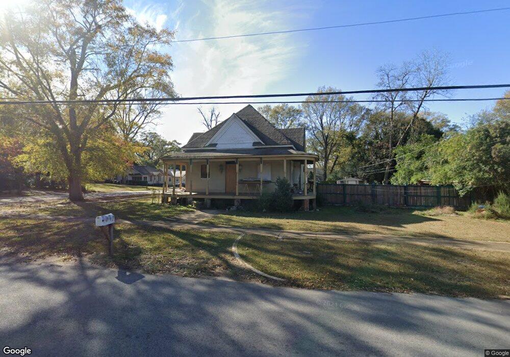
501 Avenue E West Point, GA 31833
Estimated Value: $139,000 - $183,000
3
Beds
2
Baths
2,474
Sq Ft
$64/Sq Ft
Est. Value
About This Home
This home is located at 501 Avenue E, West Point, GA 31833 and is currently estimated at $158,782, approximately $64 per square foot. 501 Avenue E is a home located in Troup County with nearby schools including West Point Elementary School, Long Cane Elementary School, and Whitesville Road Elementary School.
Ownership History
Date
Name
Owned For
Owner Type
Purchase Details
Closed on
Apr 10, 2003
Sold by
Jill A Cashman
Bought by
Cashman Eric D
Current Estimated Value
Purchase Details
Closed on
Jun 4, 2002
Sold by
Bankers Trust Co
Bought by
Jill A Cashman
Purchase Details
Closed on
Jun 3, 2002
Sold by
Nancy Tommy R and Nancy Nelson
Bought by
Bankers Trust Co
Purchase Details
Closed on
Oct 18, 1996
Sold by
Milligan Lee
Bought by
Nancy Tommy R and Nancy Nelson
Purchase Details
Closed on
Mar 1, 1983
Sold by
Blythe E Milligan
Bought by
Milligan Lee
Purchase Details
Closed on
Jul 30, 1976
Bought by
Blythe E Milligan
Purchase Details
Closed on
Jan 1, 1957
Sold by
Mrs A M French
Create a Home Valuation Report for This Property
The Home Valuation Report is an in-depth analysis detailing your home's value as well as a comparison with similar homes in the area
Home Values in the Area
Average Home Value in this Area
Purchase History
| Date | Buyer | Sale Price | Title Company |
|---|---|---|---|
| Cashman Eric D | -- | -- | |
| Jill A Cashman | $29,000 | -- | |
| Bankers Trust Co | $24,900 | -- | |
| Nancy Tommy R | $22,000 | -- | |
| Milligan Lee | -- | -- | |
| Blythe E Milligan | -- | -- | |
| -- | -- | -- |
Source: Public Records
Tax History
| Year | Tax Paid | Tax Assessment Tax Assessment Total Assessment is a certain percentage of the fair market value that is determined by local assessors to be the total taxable value of land and additions on the property. | Land | Improvement |
|---|---|---|---|---|
| 2025 | $1,584 | $47,188 | $3,120 | $44,068 |
| 2024 | $1,598 | $46,692 | $3,120 | $43,572 |
| 2023 | $719 | $46,260 | $3,120 | $43,140 |
| 2022 | $1,165 | $43,740 | $3,120 | $40,620 |
| 2021 | $1,257 | $43,680 | $3,120 | $40,560 |
| 2020 | $1,142 | $39,840 | $1,720 | $38,120 |
| 2019 | $1,098 | $38,400 | $1,720 | $36,680 |
| 2018 | $1,044 | $36,600 | $1,720 | $34,880 |
| 2017 | $1,044 | $36,600 | $1,720 | $34,880 |
| 2016 | $1,000 | $35,142 | $1,734 | $33,408 |
| 2015 | $1,002 | $35,142 | $1,734 | $33,408 |
| 2014 | $843 | $29,832 | $1,736 | $28,096 |
| 2013 | -- | $31,592 | $1,736 | $29,856 |
Source: Public Records
Map
Nearby Homes
- 506 E 6th St
- 707 E 7th St
- 1202 E 9th St
- 900 E 9th St
- 509 Cleveland St
- 1104 E 8th St
- 0 Arrowhead Dr Unit 10451860
- 112 Hillcrest Rd
- 128 Highland Dr
- 712 4th Ave
- 1418 E 10th St
- 1007 4th Ave
- 0 Sunset Dr Unit 10451831
- 1026 N 6th Ave
- 403 N 15th St
- 1508 N 4th Ave
- 302 N 6th Ave
- 514 N 8th Ave
- 811 Cherry Dr
- 902 1st St
Your Personal Tour Guide
Ask me questions while you tour the home.