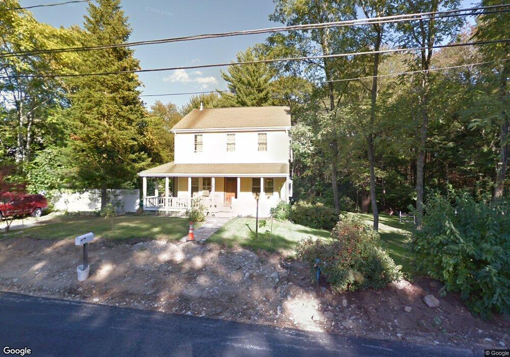
501 Bird Rd Mansfield, MA 02048
Estimated Value: $634,820 - $813,000
4
Beds
2
Baths
1,610
Sq Ft
$446/Sq Ft
Est. Value
About This Home
This home is located at 501 Bird Rd, Mansfield, MA 02048 and is currently estimated at $717,955, approximately $445 per square foot. 501 Bird Rd is a home located in Bristol County with nearby schools including Jordan/Jackson Elementary School, Everett W. Robinson Elementary School, and Harold L. Qualters Middle School.
Ownership History
Date
Name
Owned For
Owner Type
Purchase Details
Closed on
Dec 4, 2002
Sold by
Bordieri Richard S and Bordieri Kathy
Bought by
Morris Robert L and Morris Shari Ackerman
Current Estimated Value
Home Financials for this Owner
Home Financials are based on the most recent Mortgage that was taken out on this home.
Original Mortgage
$217,800
Interest Rate
6.34%
Mortgage Type
Purchase Money Mortgage
Purchase Details
Closed on
Jan 17, 1992
Sold by
Sweeney Thomas F Est
Bought by
Iram Molly
Home Financials for this Owner
Home Financials are based on the most recent Mortgage that was taken out on this home.
Original Mortgage
$96,660
Interest Rate
8.57%
Mortgage Type
Purchase Money Mortgage
Create a Home Valuation Report for This Property
The Home Valuation Report is an in-depth analysis detailing your home's value as well as a comparison with similar homes in the area
Home Values in the Area
Average Home Value in this Area
Purchase History
We collect this data history from publicly available records. To have your information removed, we recommend requesting removal directly through your county’s website.
| Date | Buyer | Sale Price | Title Company |
|---|---|---|---|
| Morris Robert L | $242,000 | -- | |
| Iram Molly | $1,000 | -- | |
| Bordieri Richard | $96,500 | -- |
Source: Public Records
Mortgage History
We collect this data history from publicly available records. To have your information removed, we recommend requesting removal directly through your county’s website.
| Date | Status | Borrower | Loan Amount |
|---|---|---|---|
| Open | Bordieri Richard | $199,300 | |
| Closed | Morris Robert L | $217,800 | |
| Previous Owner | Bordieri Richard | $100,200 | |
| Previous Owner | Bordieri Richard | $96,660 | |
| Previous Owner | Bordieri Richard | $8,000 |
Source: Public Records
Tax History
| Year | Tax Paid | Tax Assessment Tax Assessment Total Assessment is a certain percentage of the fair market value that is determined by local assessors to be the total taxable value of land and additions on the property. | Land | Improvement |
|---|---|---|---|---|
| 2025 | $6,966 | $528,900 | $253,800 | $275,100 |
| 2024 | $7,020 | $520,000 | $253,800 | $266,200 |
| 2023 | $6,803 | $482,800 | $253,800 | $229,000 |
| 2022 | $6,743 | $444,500 | $235,100 | $209,400 |
| 2021 | $3,375 | $408,000 | $205,700 | $202,300 |
| 2020 | $3,235 | $371,600 | $195,900 | $175,700 |
| 2019 | $5,510 | $362,000 | $163,200 | $198,800 |
| 2018 | $2,231 | $345,700 | $155,800 | $189,900 |
| 2017 | $5,074 | $337,800 | $151,500 | $186,300 |
| 2016 | $4,789 | $310,800 | $144,000 | $166,800 |
| 2015 | $4,597 | $296,600 | $144,000 | $152,600 |
Source: Public Records
Map
Nearby Homes
Your Personal Tour Guide
Ask me questions while you tour the home.