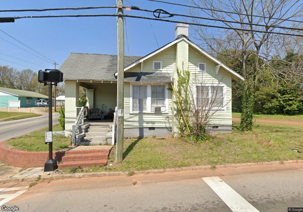
501 E Depot St Lagrange, GA 30241
Estimated Value: $63,000 - $98,000
3
Beds
1
Bath
1,138
Sq Ft
$67/Sq Ft
Est. Value
About This Home
This home is located at 501 E Depot St, Lagrange, GA 30241 and is currently estimated at $75,994, approximately $66 per square foot. 501 E Depot St is a home located in Troup County with nearby schools including Hollis Hand Elementary School, Franklin Forest Elementary School, and Ethel W. Kight Elementary School.
Ownership History
Date
Name
Owned For
Owner Type
Purchase Details
Closed on
Feb 9, 2001
Sold by
Hill Ladoris Etal
Bought by
Mallory Realty Companyinc
Current Estimated Value
Purchase Details
Closed on
Aug 10, 1998
Sold by
Lera Hughley
Bought by
Hill Ladoris Etal
Purchase Details
Closed on
Mar 29, 1977
Sold by
Wilson Lerah
Bought by
Lera Hughley
Purchase Details
Closed on
Jun 20, 1963
Sold by
Miller Mack
Bought by
Wilson Lerah
Purchase Details
Closed on
Nov 10, 1958
Sold by
Mark Annie and Mark Miller
Bought by
Miller Mack
Purchase Details
Closed on
Jan 1, 1901
Sold by
W T Carley -No Deed Book & Pg
Bought by
Mark Annie and Mark Miller
Create a Home Valuation Report for This Property
The Home Valuation Report is an in-depth analysis detailing your home's value as well as a comparison with similar homes in the area
Purchase History
| Date | Buyer | Sale Price | Title Company |
|---|---|---|---|
| Mallory Realty Companyinc | $8,500 | -- | |
| Hill Ladoris Etal | -- | -- | |
| Lera Hughley | -- | -- | |
| Wilson Lerah | -- | -- | |
| Miller Mack | -- | -- | |
| Mark Annie | -- | -- |
Source: Public Records
Tax History
| Year | Tax Paid | Tax Assessment Tax Assessment Total Assessment is a certain percentage of the fair market value that is determined by local assessors to be the total taxable value of land and additions on the property. | Land | Improvement |
|---|---|---|---|---|
| 2025 | $480 | $17,600 | $1,920 | $15,680 |
| 2024 | $364 | $13,360 | $1,920 | $11,440 |
| 2023 | $331 | $12,120 | $1,920 | $10,200 |
| 2022 | $320 | $11,480 | $1,920 | $9,560 |
| 2021 | $218 | $7,240 | $1,640 | $5,600 |
| 2020 | $241 | $7,240 | $1,640 | $5,600 |
| 2019 | $209 | $6,920 | $1,320 | $5,600 |
| 2018 | $209 | $6,920 | $1,320 | $5,600 |
| 2017 | $209 | $6,920 | $1,320 | $5,600 |
| 2016 | $200 | $6,644 | $1,244 | $5,400 |
| 2015 | $201 | $6,644 | $1,244 | $5,400 |
| 2014 | $201 | $6,644 | $1,244 | $5,400 |
| 2013 | -- | $8,622 | $1,658 | $6,964 |
Source: Public Records
Map
Nearby Homes
Your Personal Tour Guide
Ask me questions while you tour the home.