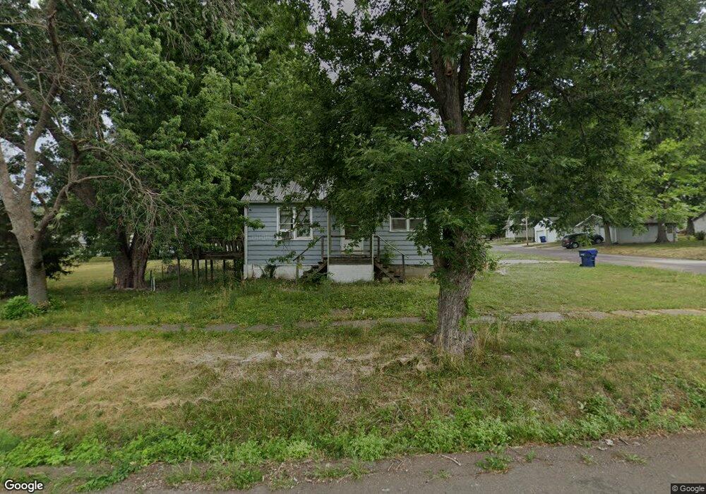
502 W Dake St Brookfield, MO 64628
Estimated Value: $61,499 - $116,000
2
Beds
1
Bath
768
Sq Ft
$111/Sq Ft
Est. Value
About This Home
This home is located at 502 W Dake St, Brookfield, MO 64628 and is currently estimated at $85,625, approximately $111 per square foot. 502 W Dake St is a home with nearby schools including Brookfield Elementary School, Brookfield Middle School, and Brookfield High School.
Ownership History
Date
Name
Owned For
Owner Type
Purchase Details
Closed on
May 20, 2024
Sold by
Pendleton Shawn
Bought by
Baum Amos
Current Estimated Value
Home Financials for this Owner
Home Financials are based on the most recent Mortgage that was taken out on this home.
Original Mortgage
$50,000
Outstanding Balance
$47,741
Interest Rate
0.7%
Mortgage Type
Construction
Estimated Equity
$37,884
Purchase Details
Closed on
Mar 27, 2024
Sold by
Southside Equipment Llc
Bought by
Pendleton Shawn
Home Financials for this Owner
Home Financials are based on the most recent Mortgage that was taken out on this home.
Original Mortgage
$50,000
Outstanding Balance
$47,741
Interest Rate
0.7%
Mortgage Type
Construction
Estimated Equity
$37,884
Purchase Details
Closed on
Jun 25, 2009
Bought by
Southside Equipment Llc
Create a Home Valuation Report for This Property
The Home Valuation Report is an in-depth analysis detailing your home's value as well as a comparison with similar homes in the area
Home Values in the Area
Average Home Value in this Area
Purchase History
| Date | Buyer | Sale Price | Title Company |
|---|---|---|---|
| Baum Amos | $62,500 | -- | |
| Pendleton Shawn | -- | -- | |
| Southside Equipment Llc | -- | -- |
Source: Public Records
Mortgage History
| Date | Status | Borrower | Loan Amount |
|---|---|---|---|
| Open | Baum Amos | $50,000 |
Source: Public Records
Tax History
| Year | Tax Paid | Tax Assessment Tax Assessment Total Assessment is a certain percentage of the fair market value that is determined by local assessors to be the total taxable value of land and additions on the property. | Land | Improvement |
|---|---|---|---|---|
| 2025 | $174 | $2,850 | $1,273 | $1,577 |
| 2024 | $2 | $2,774 | $1,273 | $1,501 |
| 2023 | $173 | $2,774 | $1,273 | $1,501 |
| 2022 | $176 | $2,812 | $1,273 | $1,539 |
| 2021 | $170 | $2,812 | $1,273 | $1,539 |
| 2020 | $176 | $2,812 | $1,273 | $1,539 |
| 2019 | $176 | $2,812 | $1,273 | $1,539 |
| 2018 | $176 | $2,812 | $1,273 | $1,539 |
| 2015 | -- | $2,793 | $1,140 | $1,653 |
| 2011 | -- | $14,700 | $6,000 | $8,700 |
Source: Public Records
Map
Nearby Homes
- 420 Mcgowan St
- 420 Smith St
- 627 Mcgowan St
- 119 W Dake St
- 431 Peck St
- 125 Maple St
- 1118 Courtland St
- 721 Lincoln St
- 1007 Country Side Dr
- 317 Macon St
- 316 Macon St
- 0 W Wood St
- 303 Shelby St
- 117 N Main St
- 117 E Clark St
- 415 S Livingston St
- 0 S State St
- 25972 County Road M
- 521 Freeman St
- 547 Harrison St
- 516 W Dake St
- 845 Strawbridge St
- 420 W Dake St
- 921 Strawbridge St
- 515 W Dake St
- 418 W Dake St
- 421 W Dake St
- 520 W Dake St
- 837 Strawbridge St
- 416 W Dake St
- 419 W Dake St
- 923 Strawbridge St
- 521 W Dake St
- 924 Strawbridge St
- 831 Strawbridge St
- 523 W Dake St
- 838 Strawbridge St
- 829 Strawbridge St
- 415 Mcgowan St
- 834 Strawbridge St
Your Personal Tour Guide
Ask me questions while you tour the home.