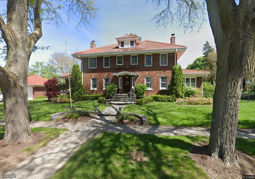
505 W Harrison Ave Wheaton, IL 60187
Northside-Wheaton NeighborhoodEstimated Value: $807,000 - $1,145,000
Studio
1
Bath
3,304
Sq Ft
$312/Sq Ft
Est. Value
About This Home
This home is located at 505 W Harrison Ave, Wheaton, IL 60187 and is currently estimated at $1,032,308, approximately $312 per square foot. 505 W Harrison Ave is a home located in DuPage County with nearby schools including Longfellow Elementary School, Franklin Middle School, and Wheaton North High School.
Ownership History
Date
Name
Owned For
Owner Type
Purchase Details
Closed on
Aug 6, 2002
Sold by
Huck Sharon A and Sharon A Huck Trust
Bought by
Doerries Michael F and Doerries Kathryn A
Current Estimated Value
Home Financials for this Owner
Home Financials are based on the most recent Mortgage that was taken out on this home.
Original Mortgage
$415,000
Outstanding Balance
$176,486
Interest Rate
6.62%
Estimated Equity
$855,822
Purchase Details
Closed on
Aug 3, 1999
Sold by
Huck James M and Huck Sharon A
Bought by
Huck Sharon A and Sharon A Huck Trust
Create a Home Valuation Report for This Property
The Home Valuation Report is an in-depth analysis detailing your home's value as well as a comparison with similar homes in the area
Home Values in the Area
Average Home Value in this Area
Purchase History
We collect this data history from publicly available records. To have your information removed, we recommend requesting removal directly through your county’s website.
| Date | Buyer | Sale Price | Title Company |
|---|---|---|---|
| Doerries Michael F | $575,000 | -- | |
| Huck Sharon A | -- | -- |
Source: Public Records
Mortgage History
We collect this data history from publicly available records. To have your information removed, we recommend requesting removal directly through your county’s website.
| Date | Status | Borrower | Loan Amount |
|---|---|---|---|
| Open | Doerries Michael F | $415,000 |
Source: Public Records
Tax History
| Year | Tax Paid | Tax Assessment Tax Assessment Total Assessment is a certain percentage of the fair market value that is determined by local assessors to be the total taxable value of land and additions on the property. | Land | Improvement |
|---|---|---|---|---|
| 2024 | $20,133 | $328,375 | $45,770 | $282,605 |
| 2023 | $19,886 | $302,260 | $42,130 | $260,130 |
| 2022 | $19,368 | $285,670 | $39,830 | $245,840 |
| 2021 | $19,314 | $278,890 | $38,880 | $240,010 |
| 2020 | $19,258 | $276,290 | $38,520 | $237,770 |
| 2019 | $18,828 | $269,000 | $37,500 | $231,500 |
| 2018 | $19,231 | $271,520 | $35,330 | $236,190 |
| 2017 | $18,963 | $261,510 | $34,030 | $227,480 |
| 2016 | $16,820 | $251,060 | $32,670 | $218,390 |
| 2015 | $17,570 | $251,450 | $43,100 | $208,350 |
| 2014 | $16,351 | $232,660 | $30,950 | $201,710 |
| 2013 | $15,935 | $233,360 | $31,040 | $202,320 |
Source: Public Records
Map
Nearby Homes
- 416 W Oak Ave
- 0N105 Lot 1 Nepil Ave
- 0N105 Lot 2 Nepil Ave
- 427 W Franklin St
- N405 Gary Ave
- 219 W Oak Ave
- 114 W Prairie Ave
- 1115 N Main St
- 1327 Shagbark Ln
- 1303 N Cross St
- 455 W Front St Unit 201
- 314 E Jefferson Ave
- 1150 Oakview Dr Unit D
- 315 E Union Ave
- 1118 Manchester Rd
- 1106 N Washington St
- 323 S Hale St
- 0N632 Gables Blvd
- 1251 W Thomas Rd
- 2061 Windham Cir
Your Personal Tour Guide
Ask me questions while you tour the home.