Estimated Value: $227,000 - $466,000
5
Beds
4
Baths
4,416
Sq Ft
$82/Sq Ft
Est. Value
About This Home
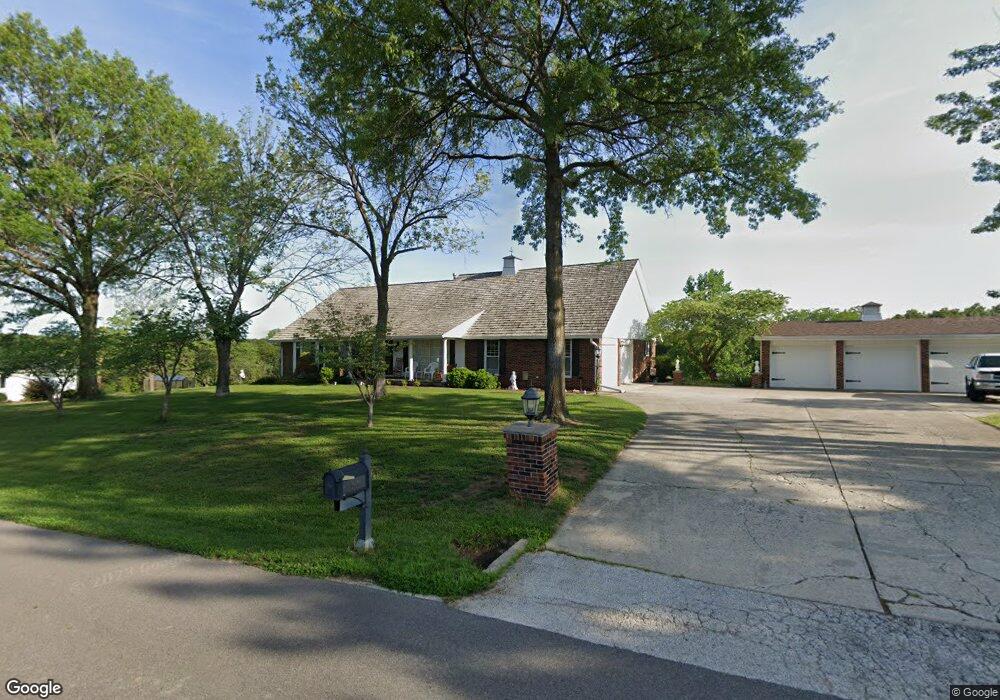
This home is located at 509 Mearns Ln, Macon, MO 63552 and is currently estimated at $361,816, approximately $81 per square foot. 509 Mearns Ln is a home located in Macon County with nearby schools including Macon Elementary School, Family Literacy Center, and Macon Middle School.
Ownership History
Date
Name
Owned For
Owner Type
Purchase Details
Closed on
Jun 13, 2024
Sold by
Roberts Darrell O and Roberts Joyce A
Bought by
Roney Gary
Current Estimated Value
Purchase Details
Closed on
Aug 13, 2021
Sold by
Celmer Kenneth T and Celmer Theresa R
Bought by
Roberts Darrell Oneil and Roberts Joyce Ann
Purchase Details
Closed on
Oct 26, 2017
Sold by
Wilhite Barbara A Trust
Bought by
Celmer Kenneth T and Celmer Theresa R
Create a Home Valuation Report for This Property
The Home Valuation Report is an in-depth analysis detailing your home's value as well as a comparison with similar homes in the area
Home Values in the Area
Average Home Value in this Area
Purchase History
| Date | Buyer | Sale Price | Title Company |
|---|---|---|---|
| Roney Gary | -- | Macon Cnty Title Llc | |
| Roberts Darrell Oneil | -- | Landco Title & Escrow | |
| Celmer Kenneth T | $228,340 | Macon Cnty Title Llc |
Source: Public Records
Mortgage History
| Date | Status | Borrower | Loan Amount |
|---|---|---|---|
| Closed | Celmer Kenneth T | $233,000 |
Source: Public Records
Tax History
| Year | Tax Paid | Tax Assessment Tax Assessment Total Assessment is a certain percentage of the fair market value that is determined by local assessors to be the total taxable value of land and additions on the property. | Land | Improvement |
|---|---|---|---|---|
| 2025 | $2,423 | $52,600 | $8,300 | $44,300 |
| 2024 | $24 | $46,970 | $0 | $0 |
| 2023 | $2,414 | $46,970 | $0 | $0 |
| 2022 | $2,322 | $46,970 | $0 | $0 |
| 2021 | $2,133 | $45,260 | $0 | $0 |
| 2020 | $2,144 | $41,800 | $0 | $0 |
| 2019 | $2,137 | $41,800 | $41,800 | $0 |
| 2018 | $1,717 | $41,800 | $41,800 | $0 |
| 2017 | $1,586 | $184,650 | $9,760 | $174,890 |
| 2016 | $1,540 | $35,080 | $0 | $0 |
| 2015 | -- | $33,870 | $0 | $0 |
| 2014 | -- | $33,870 | $0 | $0 |
| 2012 | -- | $33,870 | $0 | $0 |
Source: Public Records
Map
Nearby Homes
- 2214 U S 63
- 601 Roe Ln
- 806 Holman Ln
- 805 Jackson St
- 801 Overbrook Dr
- 608 N Rollins St
- 509 Western Dr
- 1903 W Shore Dr
- 501 Spruce St
- 1004 Meadow Ln
- 1708 Robin Hood Ln
- 302 Jackson St
- 706 Sunset Hills Dr
- 1706 Robin Hood Ln
- 1803,1805 Robin Hood Ln
- 1406 E Briggs Dr
- 802 W Bourke St
- 1410 E Briggs Dr
- 203 S Hudson St
- 1604 Sherwood Dr
- 505 Mearns Dr
- 513 Mearns Ln
- 510 Mearns Dr
- 506 Mearns Dr
- 514 Mearns Ln
- 30269 Mearns Dr
- 501 Mearns Dr
- 502 Mearns Dr
- 505 Covey Rise Ln
- 507 Covey Rise Ln
- 518 Mearns Ln
- 501 Covey Rise Ln
- 509 Covey Rise Ln
- 519 Covey Rise Ln
- 000 Kountryside Rd
- 0 Kountryside Rd
- 1912 Quail Dr
- 0 Covey Rise Ln
- 1908 Quail Dr
- 0 Quail Dr
Your Personal Tour Guide
Ask me questions while you tour the home.