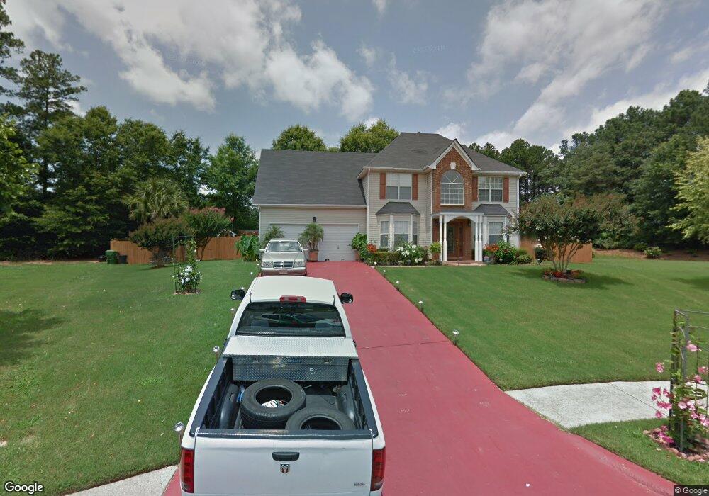
509 Michael Cir Monroe, GA 30655
Estimated Value: $346,971 - $358,000
Studio
--
Bath
2,457
Sq Ft
$144/Sq Ft
Est. Value
About This Home
This home is located at 509 Michael Cir, Monroe, GA 30655 and is currently estimated at $352,993, approximately $143 per square foot. 509 Michael Cir is a home located in Walton County with nearby schools including Atha Road Elementary School, Youth Middle School, and Walnut Grove High School.
Ownership History
Date
Name
Owned For
Owner Type
Purchase Details
Closed on
Dec 18, 2020
Sold by
Hayles Hugh
Bought by
Haye Monique M
Current Estimated Value
Home Financials for this Owner
Home Financials are based on the most recent Mortgage that was taken out on this home.
Original Mortgage
$208,160
Outstanding Balance
$184,040
Interest Rate
2.7%
Mortgage Type
FHA
Estimated Equity
$168,953
Purchase Details
Closed on
Jan 19, 2001
Sold by
Scenic Homes Inc
Bought by
Hayles Hugh
Home Financials for this Owner
Home Financials are based on the most recent Mortgage that was taken out on this home.
Original Mortgage
$142,871
Interest Rate
7.11%
Mortgage Type
FHA
Create a Home Valuation Report for This Property
The Home Valuation Report is an in-depth analysis detailing your home's value as well as a comparison with similar homes in the area
Home Values in the Area
Average Home Value in this Area
Purchase History
| Date | Buyer | Sale Price | Title Company |
|---|---|---|---|
| Haye Monique M | $212,000 | -- | |
| Hayles Hugh | $144,000 | -- |
Source: Public Records
Mortgage History
| Date | Status | Borrower | Loan Amount |
|---|---|---|---|
| Open | Haye Monique M | $208,160 | |
| Previous Owner | Hayles Hugh | $142,871 |
Source: Public Records
Tax History
| Year | Tax Paid | Tax Assessment Tax Assessment Total Assessment is a certain percentage of the fair market value that is determined by local assessors to be the total taxable value of land and additions on the property. | Land | Improvement |
|---|---|---|---|---|
| 2025 | $4,094 | $144,120 | $22,000 | $122,120 |
| 2024 | $3,935 | $138,280 | $22,000 | $116,280 |
| 2023 | $4,020 | $136,600 | $22,000 | $114,600 |
| 2022 | $3,491 | $104,960 | $17,200 | $87,760 |
| 2021 | $2,845 | $77,280 | $13,200 | $64,080 |
| 2020 | $2,589 | $71,240 | $12,400 | $58,840 |
| 2019 | $2,506 | $61,320 | $12,000 | $49,320 |
| 2018 | $2,283 | $61,320 | $12,000 | $49,320 |
| 2017 | $2,184 | $52,120 | $8,000 | $44,120 |
| 2016 | $2,057 | $51,920 | $8,000 | $43,920 |
| 2015 | $1,818 | $45,320 | $8,000 | $37,320 |
| 2014 | $1,491 | $36,480 | $0 | $0 |
Source: Public Records
Map
Nearby Homes
- 679 Michael Cir
- 675 Michael Cir
- 720 Overlook Crest
- 661 Michael Cir
- 509 Mill Farm Ln
- 509 Heritage Ridge Dr
- 605 Michael Cir
- 911 Woodchase Dr
- 943 Masters Dr Unit 2
- 925 Tigers Way
- 810 Hampton
- 250 Martin Luther King Junior Blvd
- 0 Pine View Dr Unit CL350808
- 0 Pine View Dr Unit 10706074
- 0 Pine View Dr Unit 7731449
- 505 Breedlove Dr
- 506 Breedlove Dr
- 150 Mountain View Dr
- 1269 Georgia 138
- 1309 Armistead Cir
- 511 Michael Cir
- 505 Michael Cir
- 608 Michael Etchison Rd
- 513 Michael Cir
- 880 Ashley Ct
- 503 Michael Cir
- 510 Michael Cir
- 515 Michael Cir
- 588 Michael Etchison Rd
- 618 Michael Etchison Rd
- 501 Michael Cir
- 514 Michael Cir
- 703 Overlook Crest
- 516 Michael Cir
- 705 Overlook Crest
- 519 Michael Cir
- 875 Ashley Ct
- 638 Michael Etchison Rd
- 709 Overlook Crest
- 865 Ashley Ct
Your Personal Tour Guide
Ask me questions while you tour the home.