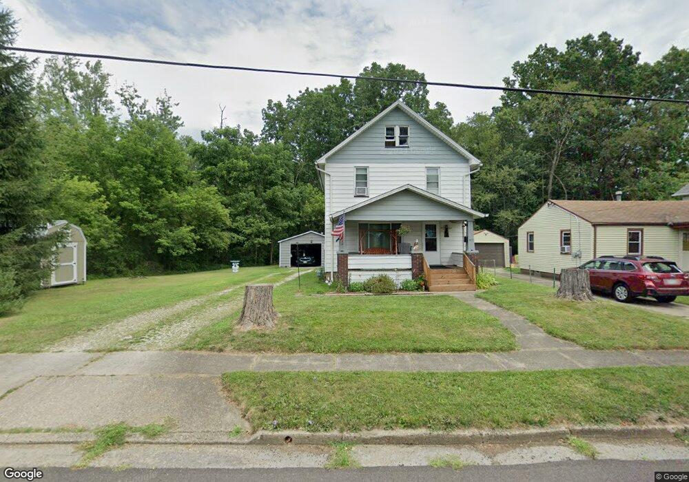
509 W Wayne St Alliance, OH 44601
Estimated Value: $71,806 - $103,000
3
Beds
1
Bath
1,144
Sq Ft
$77/Sq Ft
Est. Value
About This Home
This home is located at 509 W Wayne St, Alliance, OH 44601 and is currently estimated at $87,702, approximately $76 per square foot. 509 W Wayne St is a home located in Stark County with nearby schools including Alliance Early Learning School, Alliance Intermediate School at Northside, and Alliance Middle School.
Ownership History
Date
Name
Owned For
Owner Type
Purchase Details
Closed on
Aug 29, 2008
Sold by
Barnes Randy L and Barnes Kathy L
Bought by
Cameron Terry L and Cameron Delores D
Current Estimated Value
Home Financials for this Owner
Home Financials are based on the most recent Mortgage that was taken out on this home.
Original Mortgage
$40,267
Outstanding Balance
$26,512
Interest Rate
6.31%
Mortgage Type
FHA
Estimated Equity
$61,190
Purchase Details
Closed on
Jan 10, 2007
Sold by
Jp Morgan Chase Bank
Bought by
Barnes Randy L
Home Financials for this Owner
Home Financials are based on the most recent Mortgage that was taken out on this home.
Original Mortgage
$27,000
Interest Rate
5.86%
Mortgage Type
Purchase Money Mortgage
Purchase Details
Closed on
Mar 23, 2006
Sold by
Gibson Ronald F and Gibson Marla K
Bought by
Jp Morgan Chase Bank
Purchase Details
Closed on
May 26, 1989
Create a Home Valuation Report for This Property
The Home Valuation Report is an in-depth analysis detailing your home's value as well as a comparison with similar homes in the area
Home Values in the Area
Average Home Value in this Area
Purchase History
We collect this data history from publicly available records. To have your information removed, we recommend requesting removal directly through your county’s website.
| Date | Buyer | Sale Price | Title Company |
|---|---|---|---|
| Cameron Terry L | $41,000 | Attorney | |
| Barnes Randy L | $30,000 | Accutitle Agency Inc | |
| Jp Morgan Chase Bank | $40,000 | None Available | |
| -- | $29,500 | -- |
Source: Public Records
Mortgage History
We collect this data history from publicly available records. To have your information removed, we recommend requesting removal directly through your county’s website.
| Date | Status | Borrower | Loan Amount |
|---|---|---|---|
| Open | Cameron Terry L | $40,267 | |
| Closed | Barnes Randy L | $27,000 |
Source: Public Records
Tax History
| Year | Tax Paid | Tax Assessment Tax Assessment Total Assessment is a certain percentage of the fair market value that is determined by local assessors to be the total taxable value of land and additions on the property. | Land | Improvement |
|---|---|---|---|---|
| 2025 | -- | $20,300 | $3,500 | $16,800 |
| 2024 | -- | $20,300 | $3,500 | $16,800 |
| 2023 | $235 | $15,020 | $3,470 | $11,550 |
| 2022 | $254 | $15,020 | $3,470 | $11,550 |
| 2021 | $254 | $15,020 | $3,470 | $11,550 |
| 2020 | $545 | $12,570 | $3,010 | $9,560 |
| 2019 | $537 | $12,570 | $3,010 | $9,560 |
| 2018 | $540 | $12,570 | $3,010 | $9,560 |
| 2017 | $400 | $9,170 | $2,030 | $7,140 |
| 2016 | $403 | $9,170 | $2,030 | $7,140 |
| 2015 | $415 | $9,350 | $2,030 | $7,320 |
| 2014 | $465 | $9,980 | $2,170 | $7,810 |
| 2013 | $232 | $9,980 | $2,170 | $7,810 |
Source: Public Records
Map
Nearby Homes
- 717 Garfield Ave
- 260 W Washington St
- 105 W Ely St
- 000 Meadowbrook Ave
- 33 S Lincoln Ave
- 432 Johnson Ave
- 171 1/2 W Main St
- 550 Johnson Ave
- 0 Meadowbrook Ave
- 244 N Park Ave
- 160 Bonnieview Ave
- 456 W Broadway St
- 479 W High St
- 0 Homestead Ave NE
- 319 W Oxford St
- 1350 W Vine St
- 430 W Oxford St
- 1033 Walnut Ave
- 427 S Union Ave
- 11584 Rockhill Ave NE
- 473 W Wayne St
- 471 W Wayne St
- 474 W Wayne St
- 484 W Wayne St
- 466 W Wayne St
- 504 W Wayne St
- 441 W Wayne St
- 512 W Wayne St
- 518 W Wayne St
- 532 Mckinley Ct
- 435 W Wayne St
- 501 W Wayne St
- 551 W Wayne St
- 634 N Lincoln Ave
- 634 N Lincoln Ave
- 491 W Washington St
- 445 W Washington St
- 509 W Washington St
- 640 N Lincoln Ave
- 614 N Lincoln Ave
Your Personal Tour Guide
Ask me questions while you tour the home.