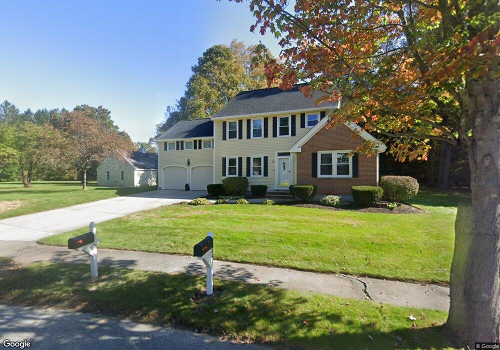
51 Phillips Common North Andover, MA 01845
Estimated Value: $956,821 - $1,206,000
3
Beds
3
Baths
2,517
Sq Ft
$418/Sq Ft
Est. Value
About This Home
This home is located at 51 Phillips Common, North Andover, MA 01845 and is currently estimated at $1,052,955, approximately $418 per square foot. 51 Phillips Common is a home located in Essex County with nearby schools including Kittredge Elementary School, North Andover Middle School, and North Andover High School.
Ownership History
Date
Name
Owned For
Owner Type
Purchase Details
Closed on
Feb 13, 2020
Sold by
Mahoney Kevin F and Mahoney Celeste M
Bought by
Kevin F & C M Mahoney Lt
Current Estimated Value
Purchase Details
Closed on
Nov 19, 1992
Sold by
Phillips Common Rt
Bought by
Mahoney Kevin F
Create a Home Valuation Report for This Property
The Home Valuation Report is an in-depth analysis detailing your home's value as well as a comparison with similar homes in the area
Home Values in the Area
Average Home Value in this Area
Purchase History
| Date | Buyer | Sale Price | Title Company |
|---|---|---|---|
| Kevin F & C M Mahoney Lt | -- | None Available | |
| Mahoney Kevin F | $229,000 | -- |
Source: Public Records
Mortgage History
| Date | Status | Borrower | Loan Amount |
|---|---|---|---|
| Previous Owner | Mahoney Kevin F | $121,000 | |
| Previous Owner | Mahoney Kevin F | $410,048 | |
| Previous Owner | Mahoney Kevin F | $175,000 | |
| Previous Owner | Mahoney Kevin F | $220,000 |
Source: Public Records
Tax History
| Year | Tax Paid | Tax Assessment Tax Assessment Total Assessment is a certain percentage of the fair market value that is determined by local assessors to be the total taxable value of land and additions on the property. | Land | Improvement |
|---|---|---|---|---|
| 2025 | $9,658 | $857,700 | $345,400 | $512,300 |
| 2024 | $9,211 | $830,600 | $327,200 | $503,400 |
| 2023 | $8,787 | $717,900 | $276,300 | $441,600 |
| 2022 | $8,504 | $628,500 | $250,800 | $377,700 |
| 2021 | $8,175 | $576,900 | $227,200 | $349,700 |
| 2020 | $7,927 | $576,900 | $227,200 | $349,700 |
| 2019 | $7,736 | $576,900 | $227,200 | $349,700 |
| 2018 | $8,382 | $576,900 | $227,200 | $349,700 |
| 2017 | $6,804 | $476,500 | $189,400 | $287,100 |
| 2016 | $6,439 | $451,200 | $188,300 | $262,900 |
| 2015 | $6,799 | $472,500 | $181,700 | $290,800 |
Source: Public Records
Map
Nearby Homes
- 19 Fernview Ave Unit 6
- 30 Fernview Ave Unit 4
- 137 Bay State Rd
- 66 Fernview Ave Unit 9
- 86 Andover St
- 80 Edgelawn Ave Unit 6
- 78 Edgelawn Ave Unit 7
- 3 Great Pond Rd
- 70 Farrwood Ave Unit 7
- 115 Mill Pond
- 47 Edgelawn Ave Unit 12
- 60 Edgelawn Ave Unit 1
- 27 Mill Pond
- 37 Lincoln St Unit 39
- 38 Village Green Dr Unit 77
- 88 Johnson St
- 42 Hewitt Ave
- 124 Quail Run Rd
- 136 Quail Run Rd
- 110 Quail Run Rd
- 43 Phillips Common
- 44 Phillips Common
- 168 Osgood St
- 59 Phillips Common
- 28 Phillips Common
- 35 Phillips Common
- 64 Phillips Common
- 27 Phillips Common
- 18 Phillips Common
- 124 Phillips Common
- 67 Phillips Common
- 78 Phillips Common
- 19 Phillips Common
- 139 Osgood St
- 114 Phillips Common
- 75 Phillips Common
- 88 Phillips Common
- 11 Phillips Common
- 120 Osgood St
- 125 Phillips Common
Your Personal Tour Guide
Ask me questions while you tour the home.