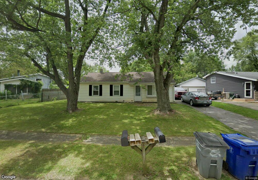
5125 Kickapoo Dr Kokomo, IN 46902
Indian Heights NeighborhoodEstimated Value: $115,380 - $138,000
3
Beds
1
Bath
1,040
Sq Ft
$125/Sq Ft
Est. Value
About This Home
This home is located at 5125 Kickapoo Dr, Kokomo, IN 46902 and is currently estimated at $130,095, approximately $125 per square foot. 5125 Kickapoo Dr is a home located in Howard County with nearby schools including Taylor Elementary School, Taylor Middle School, and Taylor High School.
Ownership History
Date
Name
Owned For
Owner Type
Purchase Details
Closed on
Mar 8, 2022
Sold by
Armstrong Properties Llc
Bought by
Childress Roger L
Current Estimated Value
Home Financials for this Owner
Home Financials are based on the most recent Mortgage that was taken out on this home.
Original Mortgage
$66,445
Outstanding Balance
$61,456
Interest Rate
3.69%
Mortgage Type
New Conventional
Estimated Equity
$68,639
Create a Home Valuation Report for This Property
The Home Valuation Report is an in-depth analysis detailing your home's value as well as a comparison with similar homes in the area
Home Values in the Area
Average Home Value in this Area
Purchase History
| Date | Buyer | Sale Price | Title Company |
|---|---|---|---|
| Childress Roger L | $68,500 | Jaquinde William |
Source: Public Records
Mortgage History
| Date | Status | Borrower | Loan Amount |
|---|---|---|---|
| Open | Childress Roger L | $66,445 |
Source: Public Records
Tax History
| Year | Tax Paid | Tax Assessment Tax Assessment Total Assessment is a certain percentage of the fair market value that is determined by local assessors to be the total taxable value of land and additions on the property. | Land | Improvement |
|---|---|---|---|---|
| 2025 | $566 | $85,000 | $11,800 | $73,200 |
| 2024 | $516 | $76,000 | $11,800 | $64,200 |
| 2022 | $438 | $63,500 | $11,800 | $51,700 |
| 2021 | $1,052 | $52,400 | $9,200 | $43,200 |
| 2020 | $942 | $46,900 | $9,200 | $37,700 |
| 2019 | $847 | $42,100 | $9,200 | $32,900 |
| 2018 | $1,203 | $39,700 | $9,200 | $30,500 |
| 2017 | $1,112 | $39,900 | $10,400 | $29,500 |
| 2016 | $807 | $39,900 | $10,400 | $29,500 |
| 2014 | $743 | $36,900 | $10,400 | $26,500 |
| 2013 | $773 | $38,400 | $10,400 | $28,000 |
Source: Public Records
Map
Nearby Homes
- 4908 Council Ring Blvd
- 4908 Algonquin Trail
- 4011 Highland Springs Dr
- 846 Springwater Rd
- 5625 Wigwam Ct
- 1116 Spring Hill Dr
- 910 Highland Springs Ln
- 833 Lando Creek Dr
- 907 Wingra Ct
- 5716 Council Ring Blvd
- 903 Wingra Ct
- 844 Lando Creek Dr
- 5914 Monona Dr
- 5564 Golden Gate Way
- 4103 Toni Dr
- 239 W Pipeline Way
- 4117 Toni Dr
- 3613 Candy Ln
- 236 W 400 S
- 0 Albright Rd
- 5123 Kickapoo Dr
- 5108 Council Ring Blvd
- 5110 Council Ring Blvd
- 5121 Kickapoo Dr
- 5106 Council Ring Blvd
- 5200 Council Ring Blvd
- 5104 Council Ring Blvd
- 5119 Kickapoo Dr
- 5128 Kickapoo Dr
- 5124 Kickapoo Dr
- 5122 Kickapoo Dr
- 5126 Kickapoo Dr
- 5202 Council Ring Blvd
- 5102 Council Ring Blvd
- 5120 Kickapoo Dr
- 5117 Kickapoo Dr
- 5107 Council Ring Blvd
- 5105 Council Ring Blvd
- 5201 Council Ring Blvd
- 5103 Council Ring Blvd
Your Personal Tour Guide
Ask me questions while you tour the home.