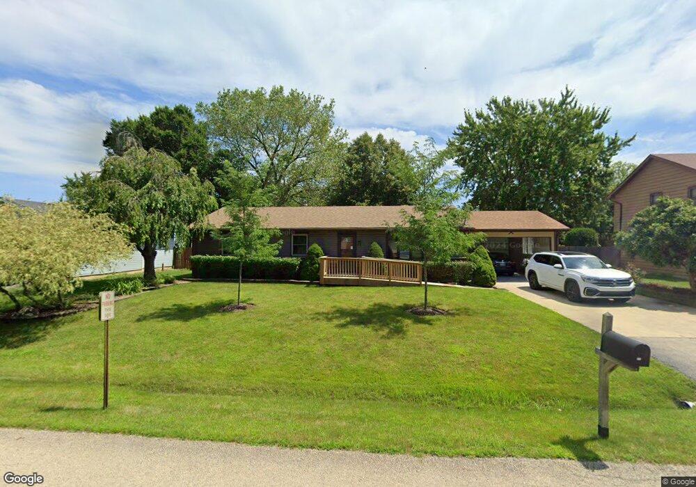
513 Cavin Ave Winthrop Harbor, IL 60096
Estimated Value: $307,000 - $339,000
3
Beds
2
Baths
1,344
Sq Ft
$243/Sq Ft
Est. Value
About This Home
This home is located at 513 Cavin Ave, Winthrop Harbor, IL 60096 and is currently estimated at $326,357, approximately $242 per square foot. 513 Cavin Ave is a home located in Lake County with nearby schools including Westfield School, North Prairie Junior High School, and Zion-Benton Township High School.
Ownership History
Date
Name
Owned For
Owner Type
Purchase Details
Closed on
Feb 20, 2001
Sold by
Berg Jeffrey A and Berg Debra M
Bought by
Larson Michael Toco
Current Estimated Value
Home Financials for this Owner
Home Financials are based on the most recent Mortgage that was taken out on this home.
Original Mortgage
$146,000
Interest Rate
7.05%
Create a Home Valuation Report for This Property
The Home Valuation Report is an in-depth analysis detailing your home's value as well as a comparison with similar homes in the area
Home Values in the Area
Average Home Value in this Area
Purchase History
| Date | Buyer | Sale Price | Title Company |
|---|---|---|---|
| Larson Michael Toco | $166,000 | First American Title |
Source: Public Records
Mortgage History
| Date | Status | Borrower | Loan Amount |
|---|---|---|---|
| Previous Owner | Larson Michael Toco | $146,000 |
Source: Public Records
Tax History
| Year | Tax Paid | Tax Assessment Tax Assessment Total Assessment is a certain percentage of the fair market value that is determined by local assessors to be the total taxable value of land and additions on the property. | Land | Improvement |
|---|---|---|---|---|
| 2024 | $7,514 | $90,831 | $8,253 | $82,578 |
| 2023 | $7,609 | $78,100 | $7,967 | $70,133 |
| 2022 | $7,609 | $75,529 | $7,775 | $67,754 |
| 2021 | $6,740 | $64,500 | $7,577 | $56,923 |
| 2020 | $6,531 | $61,552 | $7,231 | $54,321 |
| 2019 | $6,367 | $58,399 | $6,861 | $51,538 |
| 2018 | $6,226 | $57,043 | $8,258 | $48,785 |
| 2017 | $6,174 | $53,663 | $7,769 | $45,894 |
| 2016 | $6,006 | $51,088 | $7,396 | $43,692 |
| 2015 | $5,885 | $46,853 | $6,783 | $40,070 |
| 2014 | $5,808 | $47,892 | $9,542 | $38,350 |
| 2012 | $5,732 | $49,768 | $9,916 | $39,852 |
Source: Public Records
Map
Nearby Homes
- 535 Thompson Ave
- 0 Garnett Ave
- 514 Judith Ct
- 338 College Ave
- 802 Kirkwood Ave
- 630 Whitney Ave
- 150 Old Darby Ln
- 714 Landon Ave
- 907 E Broadway Ave Unit E
- 0 13th St Unit MRD12569828
- 3106 13th St
- 1134 Franklin Ave
- 1808 13th St
- 0 14th St Unit MRD12502206
- 1206 Landon Ave
- 12212 Sheridan Rd
- 1400 Sheridan Rd
- 1715 14th St
- 11912 28th Ave
- 0 Sheridan Rd Unit MRD12548005
Your Personal Tour Guide
Ask me questions while you tour the home.