Estimated Value: $268,806 - $296,000
3
Beds
2
Baths
1,306
Sq Ft
$220/Sq Ft
Est. Value
About This Home
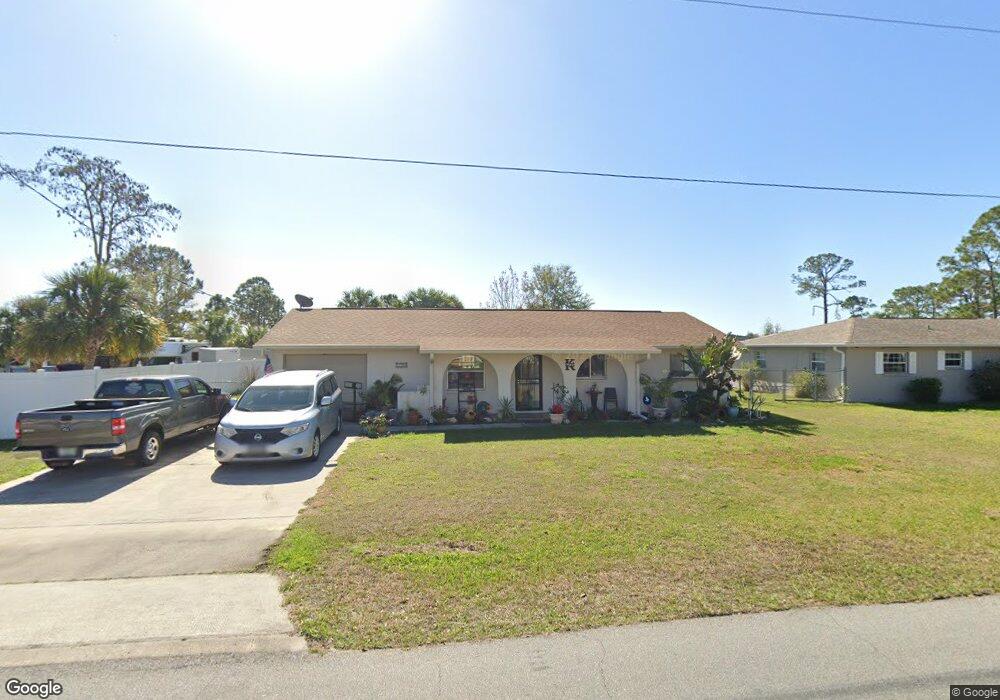
This home is located at 5145 Bridge Rd, Cocoa, FL 32927 and is currently estimated at $287,952, approximately $220 per square foot. 5145 Bridge Rd is a home located in Brevard County with nearby schools including Challenger 7 Elementary School, Space Coast Junior/Senior High School, and East Atlantic Prep of Brevard County.
Ownership History
Date
Name
Owned For
Owner Type
Purchase Details
Closed on
May 6, 2011
Sold by
Weavers Cindi S
Bought by
Kyte Dana and Kyte Billie June
Current Estimated Value
Purchase Details
Closed on
Mar 19, 2008
Sold by
Ross Debra S
Bought by
Weavers Cindi S
Home Financials for this Owner
Home Financials are based on the most recent Mortgage that was taken out on this home.
Original Mortgage
$122,000
Interest Rate
5.62%
Purchase Details
Closed on
Oct 7, 1996
Sold by
Rittenhouse Shirley J
Bought by
Rittenhouse Shirley J and Ross Debra S
Create a Home Valuation Report for This Property
The Home Valuation Report is an in-depth analysis detailing your home's value as well as a comparison with similar homes in the area
Home Values in the Area
Average Home Value in this Area
Purchase History
We collect this data history from publicly available records. To have your information removed, we recommend requesting removal directly through your county’s website.
| Date | Buyer | Sale Price | Title Company |
|---|---|---|---|
| Kyte Dana | $49,000 | Accurate Title Group | |
| Weavers Cindi S | $122,000 | Security First Title Partner | |
| Rittenhouse Shirley J | $10,000 | -- |
Source: Public Records
Mortgage History
We collect this data history from publicly available records. To have your information removed, we recommend requesting removal directly through your county’s website.
| Date | Status | Borrower | Loan Amount |
|---|---|---|---|
| Previous Owner | Weavers Cindi S | $122,000 |
Source: Public Records
Tax History
| Year | Tax Paid | Tax Assessment Tax Assessment Total Assessment is a certain percentage of the fair market value that is determined by local assessors to be the total taxable value of land and additions on the property. | Land | Improvement |
|---|---|---|---|---|
| 2025 | $2,178 | $170,790 | -- | -- |
| 2024 | $2,140 | $165,980 | -- | -- |
| 2023 | $2,140 | $161,150 | $0 | $0 |
| 2022 | $1,999 | $156,460 | $0 | $0 |
| 2021 | $2,033 | $151,910 | $42,000 | $109,910 |
| 2020 | $2,192 | $136,250 | $40,000 | $96,250 |
| 2019 | $2,076 | $131,510 | $35,000 | $96,510 |
| 2018 | $1,970 | $119,960 | $27,000 | $92,960 |
| 2017 | $1,870 | $107,090 | $24,000 | $83,090 |
| 2016 | $1,752 | $91,610 | $18,000 | $73,610 |
| 2015 | $1,291 | $72,520 | $15,000 | $57,520 |
| 2014 | $1,150 | $65,930 | $11,000 | $54,930 |
Source: Public Records
Map
Nearby Homes
- 5950 Ackard Ave
- 6020 Cannon Ave
- 5945 Coker Ave
- 5221 Carrick Rd
- 5946 Deer Ln
- 5209 Holden Rd
- 6180 Grissom Pkwy
- 5220 Holden Rd
- 6240 Grissom Pkwy
- 6162 Rena Ave
- 5614 Jamaica Rd
- 5687 Holden Rd
- 6375 Cable Ave
- 6310 Depot Ave
- 6442 Fairchild Ave
- 6438 Hudson Rd
- 5424 Flint Rd
- 6450 Ember Ave
- 6350 Depot Ave
- 00 Unknown
- 5157 Bridge Rd
- 5169 Bridge Rd
- 5121 Bridge Rd
- 5146 Bridge Rd
- 0 Bridge Rd
- 5915 Cannon Ave
- 5134 Bridge Rd
- 5181 Bridge Rd Unit 4
- 5109 Bridge Rd
- 5910 Cannon Ave
- 5925 Cannon Ave
- 5920 Ackard Ave
- 5913 Ackard Ave
- 5193 Bridge Rd
- 5097 Bridge Rd
- 5186 Bridge Rd
- 5201 Sanbourne St
- 5935 Cannon Ave Unit 2418
- 5935 Cannon Ave
- 5923 Ackard Ave
Your Personal Tour Guide
Ask me questions while you tour the home.