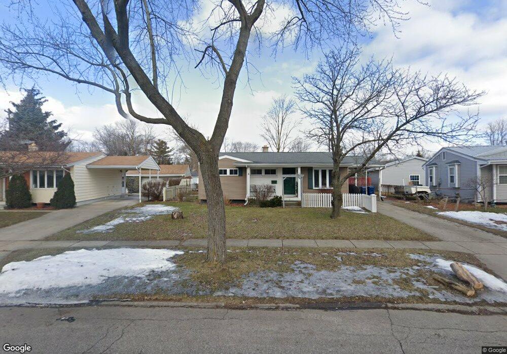
515 Tamarac Dr Davison, MI 48423
Estimated Value: $200,258 - $215,000
3
Beds
1
Bath
1,018
Sq Ft
$205/Sq Ft
Est. Value
About This Home
This home is located at 515 Tamarac Dr, Davison, MI 48423 and is currently estimated at $208,315, approximately $204 per square foot. 515 Tamarac Dr is a home located in Genesee County with nearby schools including Thomson Elementary School, Hill Elementary School, and Gates Elementary School.
Ownership History
Date
Name
Owned For
Owner Type
Purchase Details
Closed on
Dec 22, 2007
Sold by
Brunell Charles L and Brunell Lisa M
Bought by
Layman Jared R and Layman Lindsay M
Current Estimated Value
Home Financials for this Owner
Home Financials are based on the most recent Mortgage that was taken out on this home.
Original Mortgage
$93,877
Interest Rate
6.39%
Mortgage Type
Purchase Money Mortgage
Purchase Details
Closed on
Dec 13, 2001
Sold by
Vukelich Gerald E and Vukelich Julie L
Bought by
Brunell Charles L
Create a Home Valuation Report for This Property
The Home Valuation Report is an in-depth analysis detailing your home's value as well as a comparison with similar homes in the area
Home Values in the Area
Average Home Value in this Area
Purchase History
We collect this data history from publicly available records. To have your information removed, we recommend requesting removal directly through your county’s website.
| Date | Buyer | Sale Price | Title Company |
|---|---|---|---|
| Layman Jared R | $92,000 | Lawyers Title | |
| Brunell Charles L | $104,500 | -- |
Source: Public Records
Mortgage History
We collect this data history from publicly available records. To have your information removed, we recommend requesting removal directly through your county’s website.
| Date | Status | Borrower | Loan Amount |
|---|---|---|---|
| Previous Owner | Layman Jared R | $93,877 |
Source: Public Records
Tax History
| Year | Tax Paid | Tax Assessment Tax Assessment Total Assessment is a certain percentage of the fair market value that is determined by local assessors to be the total taxable value of land and additions on the property. | Land | Improvement |
|---|---|---|---|---|
| 2025 | $1,619 | $81,200 | $0 | $0 |
| 2024 | $1,585 | $72,500 | $0 | $0 |
| 2023 | $1,522 | $66,900 | $0 | $0 |
| 2022 | $2,274 | $59,300 | $0 | $0 |
| 2021 | $2,145 | $56,000 | $0 | $0 |
| 2020 | $1,321 | $55,200 | $0 | $0 |
| 2019 | $1,304 | $52,200 | $0 | $0 |
| 2018 | $1,903 | $45,700 | $0 | $0 |
| 2017 | $1,812 | $46,300 | $0 | $0 |
| 2016 | $1,798 | $42,100 | $0 | $0 |
| 2015 | $1,792 | $37,400 | $0 | $0 |
| 2012 | -- | $35,800 | $35,800 | $0 |
Source: Public Records
Map
Nearby Homes
- 425 Juniper Dr
- 729 Fitzner Dr
- 719 Fitzner Dr
- 814 Cypress Dr
- 334 E Clark St Unit 340 344
- 1024 Foxglove Ln
- 0000 S State Rd
- 000 Foxglove Ln
- 10.63(+/-) Acres Lapeer Rd
- 325 Viet St
- 9469 Parkwood N
- 1085 Linda Dr
- 1084 Linda Dr
- 9448 Linda Dr
- 9434 Linda Dr
- 1215 N Oak Rd
- 612 Carriage Way
- 10294 Carriage Way
- 218 N Lapeer St
- 604 Amesbury Dr
Your Personal Tour Guide
Ask me questions while you tour the home.