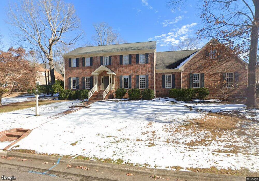
518 Arbutus Dr E Roanoke Rapids, NC 27870
Estimated Value: $471,000 - $575,000
4
Beds
4
Baths
3,680
Sq Ft
$141/Sq Ft
Est. Value
About This Home
This home is located at 518 Arbutus Dr E, Roanoke Rapids, NC 27870 and is currently estimated at $518,482, approximately $140 per square foot. 518 Arbutus Dr E is a home located in Halifax County with nearby schools including Roanoke Rapids High School, Gingerbread House, and Miracle Tabernacle Christian School.
Ownership History
Date
Name
Owned For
Owner Type
Purchase Details
Closed on
Apr 26, 2021
Sold by
Barnes Robert B and Barnes Danita W
Bought by
Tolbert Dodi E
Current Estimated Value
Home Financials for this Owner
Home Financials are based on the most recent Mortgage that was taken out on this home.
Original Mortgage
$375,000
Outstanding Balance
$339,844
Interest Rate
3.1%
Mortgage Type
VA
Estimated Equity
$178,638
Create a Home Valuation Report for This Property
The Home Valuation Report is an in-depth analysis detailing your home's value as well as a comparison with similar homes in the area
Purchase History
| Date | Buyer | Sale Price | Title Company |
|---|---|---|---|
| Tolbert Dodi E | $375,000 | None Available |
Source: Public Records
Mortgage History
| Date | Status | Borrower | Loan Amount |
|---|---|---|---|
| Open | Tolbert Dodi E | $375,000 |
Source: Public Records
Tax History
| Year | Tax Paid | Tax Assessment Tax Assessment Total Assessment is a certain percentage of the fair market value that is determined by local assessors to be the total taxable value of land and additions on the property. | Land | Improvement |
|---|---|---|---|---|
| 2025 | $66 | $412,300 | $47,500 | $364,800 |
| 2024 | $66 | $412,300 | $47,500 | $364,800 |
| 2023 | $5,445 | $318,600 | $47,500 | $271,100 |
| 2022 | $5,531 | $318,600 | $47,500 | $271,100 |
| 2021 | $5,395 | $318,600 | $47,500 | $271,100 |
| 2020 | $5,450 | $318,600 | $47,500 | $271,100 |
| 2019 | $5,183 | $298,500 | $44,300 | $254,200 |
| 2018 | $5,180 | $298,500 | $44,300 | $254,200 |
| 2017 | $5,085 | $298,500 | $44,300 | $254,200 |
| 2016 | $5,207 | $298,500 | $44,300 | $254,200 |
| 2015 | $4,955 | $298,500 | $44,300 | $254,200 |
| 2014 | $5,151 | $323,940 | $46,210 | $277,730 |
Source: Public Records
Map
Nearby Homes
- 103 Bayberry Ct
- 600 Virginia St
- 538 Virginia St
- 506 Virginia St
- 611 Park Ave
- 1111 E 7th St
- 740 Rivers Edge Pkwy
- 741 Rivers Edge Pkwy
- 742 Rivers Edge Pkwy
- 792 Rivers Edge Pkwy
- 744 Rivers Edge Pkwy
- 746 Rivers Edge Pkwy
- 748 Rivers Edge Pkwy
- 786 Rivers Edge Pkwy
- 537 Jefferson St
- 784 Rivers Edge Pkwy
- 753 Rivers Edge Pkwy
- 755 Rivers Edge Pkwy
- 3rd Straight Rd
- 769 Rivers Edge Pkwy
Your Personal Tour Guide
Ask me questions while you tour the home.