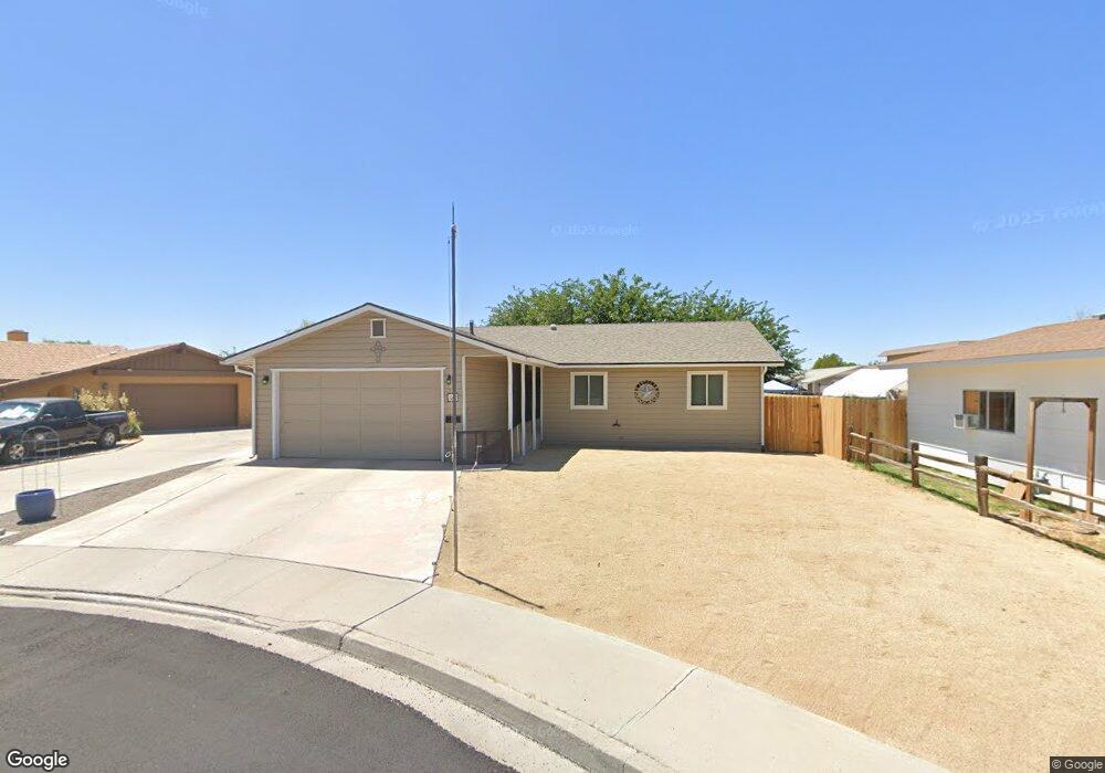
520 Rachel Ct Fallon, NV 89406
Estimated Value: $302,000 - $365,000
About This Home
This home is located at 520 Rachel Ct, Fallon, NV 89406 and is currently estimated at $331,889, approximately $201 per square foot. 520 Rachel Ct is a home located in Churchill County with nearby schools including Lahontan Elementary School, E.C. Best Elementary School, and Numa Elementary School.
Ownership History
We collect this data history from publicly available records. To have your information removed, we recommend requesting removal directly through your county’s website.
Purchase Details
Home Financials for this Owner
Home Financials are based on the most recent Mortgage that was taken out on this home.Purchase Details
Purchase Details
Home Values in the Area
Average Home Value in this Area
Purchase History
We collect this data history from publicly available records. To have your information removed, we recommend requesting removal directly through your county’s website.
| Date | Buyer | Sale Price | Title Company |
|---|---|---|---|
| $175,000 | Etrco Llc | ||
| -- | None Available | ||
| -- | None Available |
Mortgage History
We collect this data history from publicly available records. To have your information removed, we recommend requesting removal directly through your county’s website.
| Date | Status | Borrower | Loan Amount |
|---|---|---|---|
| Open | $175,000 |
Tax History
We collect this data history from publicly available records. To have your information removed, we recommend requesting removal directly through your county’s website.
| Year | Tax Paid | Tax Assessment Tax Assessment Total Assessment is a certain percentage of the fair market value that is determined by local assessors to be the total taxable value of land and additions on the property. | Land | Improvement |
|---|---|---|---|---|
| 2025 | $1,095 | $56,949 | $14,770 | $42,179 |
| 2024 | $1,095 | $57,029 | $14,000 | $43,029 |
| 2023 | $1,095 | $53,922 | $13,230 | $40,692 |
| 2022 | $1,060 | $44,170 | $8,610 | $35,560 |
| 2021 | $1,042 | $42,846 | $8,610 | $34,236 |
| 2020 | $1,085 | $29,467 | $8,610 | $35,257 |
| 2019 | $1,584 | $44,002 | $8,610 | $35,392 |
| 2018 | $1,512 | $43,257 | $8,610 | $34,647 |
| 2017 | $1,451 | $42,965 | $7,875 | $35,090 |
| 2016 | $1,415 | $41,111 | $7,875 | $33,236 |
| 2015 | $1,388 | $37,517 | $7,875 | $29,642 |
| 2014 | $1,355 | $35,129 | $7,875 | $27,254 |
Map
- 900 Joyce Ct
- 800 W 5th St
- 1060 Lee Ave
- 380 S Bailey St
- 1500 Manchester Cir
- 861 W Center St
- 841 W Center St
- 745 W Center St
- 1065 Deena Way
- 250 S Taylor St
- 210 S Taylor St
- 58 Venturacci Ln
- 960 Mark Ave
- 1291 S Taylor St
- 345 Lincoln St
- 1.55 Acres on S Maine St
- 1091 Tiffany Dr
- 1044 Allen Rd
- 12017 Power Line Rd
- 009-291-74 00929174
Ask me questions while you tour the home.