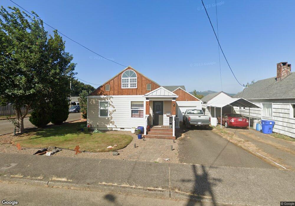
524 Cedar Ave Tillamook, OR 97141
Estimated Value: $312,102 - $355,000
2
Beds
1
Bath
1,292
Sq Ft
$253/Sq Ft
Est. Value
About This Home
This home is located at 524 Cedar Ave, Tillamook, OR 97141 and is currently estimated at $327,276, approximately $253 per square foot. 524 Cedar Ave is a home located in Tillamook County with nearby schools including Tillamook High School.
Ownership History
Date
Name
Owned For
Owner Type
Purchase Details
Closed on
Dec 7, 2016
Sold by
Baldwin Tyler J
Bought by
Collier Shirland E
Current Estimated Value
Home Financials for this Owner
Home Financials are based on the most recent Mortgage that was taken out on this home.
Original Mortgage
$157,500
Outstanding Balance
$125,966
Interest Rate
3.47%
Mortgage Type
New Conventional
Estimated Equity
$201,310
Purchase Details
Closed on
Jun 28, 2011
Sold by
Dayton Michael E and Dayton Lisa M
Bought by
Baldwin Tyler J
Home Financials for this Owner
Home Financials are based on the most recent Mortgage that was taken out on this home.
Original Mortgage
$130,569
Interest Rate
4.55%
Mortgage Type
New Conventional
Purchase Details
Closed on
Feb 21, 2011
Sold by
Fannie Mae
Bought by
Dayton Michael E and Dayton Lisa M
Purchase Details
Closed on
Apr 16, 2010
Sold by
Parker Shawn
Bought by
Federal National Mortgage Association
Create a Home Valuation Report for This Property
The Home Valuation Report is an in-depth analysis detailing your home's value as well as a comparison with similar homes in the area
Home Values in the Area
Average Home Value in this Area
Purchase History
| Date | Buyer | Sale Price | Title Company |
|---|---|---|---|
| Collier Shirland E | $175,000 | First American | |
| Baldwin Tyler J | $126,000 | Ticor Title Company | |
| Dayton Michael E | $52,500 | Ticor | |
| Federal National Mortgage Association | $120,816 | None Available |
Source: Public Records
Mortgage History
| Date | Status | Borrower | Loan Amount |
|---|---|---|---|
| Open | Collier Shirland E | $157,500 | |
| Previous Owner | Baldwin Tyler J | $130,569 |
Source: Public Records
Tax History
| Year | Tax Paid | Tax Assessment Tax Assessment Total Assessment is a certain percentage of the fair market value that is determined by local assessors to be the total taxable value of land and additions on the property. | Land | Improvement |
|---|---|---|---|---|
| 2025 | $1,848 | $153,340 | $46,670 | $106,670 |
| 2024 | $1,756 | $148,880 | $45,310 | $103,570 |
| 2023 | $1,740 | $144,550 | $43,990 | $100,560 |
| 2022 | $1,680 | $140,340 | $42,710 | $97,630 |
| 2021 | $1,631 | $136,260 | $41,470 | $94,790 |
| 2020 | $1,586 | $132,300 | $40,260 | $92,040 |
| 2019 | $1,546 | $128,450 | $39,090 | $89,360 |
| 2018 | $1,506 | $124,710 | $37,950 | $86,760 |
| 2017 | $1,438 | $118,570 | $36,840 | $81,730 |
| 2016 | $1,384 | $115,120 | $35,770 | $79,350 |
| 2015 | $1,356 | $111,770 | $34,730 | $77,040 |
| 2014 | $1,333 | $108,520 | $33,720 | $74,800 |
| 2013 | -- | $87,850 | $32,740 | $55,110 |
Source: Public Records
Map
Nearby Homes
- 1403 5th St
- 702 Ash Ave
- 605 Cottonwood Ave
- 608 Cottonwood Ave
- 116 Cedar Ave
- 1802 8th St
- 1708 4th St
- 1003 Grove Ave
- 1806 8th St
- 02600 12th St
- 2213 10th St
- 903 Madrona Ave
- TL# 02100 Wilson River Hwy
- 00201 Wilson River Hwy
- Parcel 1 Wilson River Hwy
- Parcel 2 Wilson River Hwy
- 2410 3rd St
- 2418 1st St
- 2505 1st St
- 2506 1st St
Your Personal Tour Guide
Ask me questions while you tour the home.