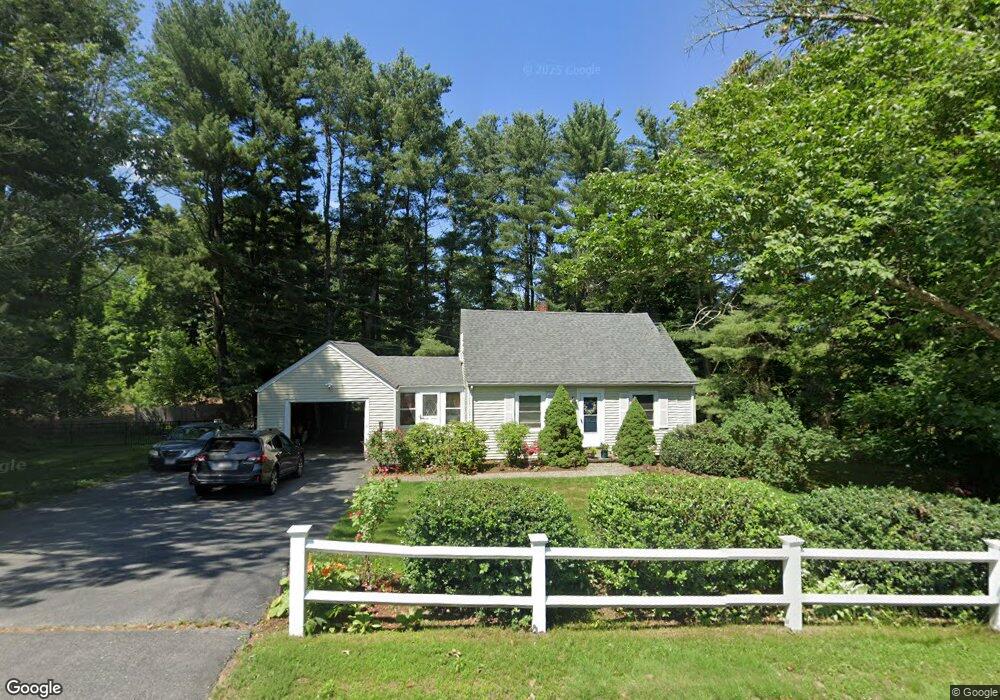
531 West St Walpole, MA 02081
Estimated Value: $546,000 - $659,000
2
Beds
2
Baths
1,142
Sq Ft
$522/Sq Ft
Est. Value
About This Home
This home is located at 531 West St, Walpole, MA 02081 and is currently estimated at $595,716, approximately $521 per square foot. 531 West St is a home located in Norfolk County with nearby schools including Elm Street School, Eleanor N. Johnson Middle School, and Walpole High School.
Ownership History
Date
Name
Owned For
Owner Type
Purchase Details
Closed on
Nov 30, 2000
Sold by
Kunelius Paul E and Kunelius Barbara M
Bought by
Dawkins Lorna D
Current Estimated Value
Home Financials for this Owner
Home Financials are based on the most recent Mortgage that was taken out on this home.
Original Mortgage
$213,750
Outstanding Balance
$79,109
Interest Rate
7.76%
Mortgage Type
Purchase Money Mortgage
Estimated Equity
$516,607
Create a Home Valuation Report for This Property
The Home Valuation Report is an in-depth analysis detailing your home's value as well as a comparison with similar homes in the area
Home Values in the Area
Average Home Value in this Area
Purchase History
| Date | Buyer | Sale Price | Title Company |
|---|---|---|---|
| Dawkins Lorna D | $225,000 | -- |
Source: Public Records
Mortgage History
| Date | Status | Borrower | Loan Amount |
|---|---|---|---|
| Open | Dawkins Lorna D | $213,750 |
Source: Public Records
Tax History
| Year | Tax Paid | Tax Assessment Tax Assessment Total Assessment is a certain percentage of the fair market value that is determined by local assessors to be the total taxable value of land and additions on the property. | Land | Improvement |
|---|---|---|---|---|
| 2025 | $6,407 | $499,400 | $295,700 | $203,700 |
| 2024 | $6,241 | $472,100 | $284,500 | $187,600 |
| 2023 | $6,073 | $437,200 | $247,400 | $189,800 |
| 2022 | $5,736 | $396,700 | $228,800 | $167,900 |
| 2021 | $5,400 | $363,900 | $215,700 | $148,200 |
| 2020 | $5,235 | $349,200 | $193,100 | $156,100 |
| 2019 | $5,074 | $336,000 | $186,500 | $149,500 |
| 2018 | $4,505 | $295,000 | $168,100 | $126,900 |
| 2017 | $4,357 | $284,200 | $161,800 | $122,400 |
| 2016 | $4,293 | $275,900 | $166,500 | $109,400 |
| 2015 | $3,886 | $247,500 | $142,200 | $105,300 |
| 2014 | $3,751 | $238,000 | $142,200 | $95,800 |
Source: Public Records
Map
Nearby Homes
- 25 Sandtrap Cir Unit 8
- 29 Sandtrap Cir Unit 6
- 27 Sandtrap Cir Unit 7
- 21 Sandtrap Cir Unit 10
- 23 Sandtrap Cir Unit 9
- 27 Sandtrip Cir Unit 7
- 3 Weathervane Dr Unit 1
- 31 Sandtrap Cir Unit 500
- 10 Sandtrap Cir Unit 2
- 13 Sandtrap Cir Unit 14
- 11 Sandtrap Cir Unit 15
- 12 Weathervane Dr Unit 21
- 20 Sandtrap Cir Unit 4
- 19 Sandtrap Cir Unit 11
- 14 Weathervane Dr Unit 22
- 18 Sandtrap Cir Unit 3
- 17 Sandtrap Cir Unit 12
- 15 Sandtrap Cir Unit 13
- 10 Weathervane Dr Unit 20
- 195 Lincoln Rd
Your Personal Tour Guide
Ask me questions while you tour the home.